- Home
- About
- Map
- Trips
- Bringing Boat West
- Migration West
- Solo Motorcycle Ride
- Final Family XC Trip
- Colorado Rockies
- Graduates' XC Trip
- Yosemite & Nevada
- Colorado & Utah
- Best of Utah
- Southern Loop
- Pacific Northwest
- Northern Loop
- Los Angeles to NYC
- East Coast Trips
- Martha's Vineyard
- 1 Week in Quebec
- Southeast Coast
- NH Backpacking
- Martha's Vineyard
- Canadian Maritimes
- Ocracoke Island
- Edisto Island
- First Landing '02
- Hunting Island '02
- Stowe in Winter
- Hunting Island '01
- Lake Placid
- Chesapeake
- Provincetown
- Hunting Island '00
- Acadia in Winter
- Boston Suburbs
- Niagara Falls
- First Landing '99
- Cape Hatteras
- West Coast Trips
- Burning Man
- Utah Off-Roading
- Maui
- Mojave 4WD Course
- Colorado River Rafting
- Bishop & Death Valley
- Kauai
- Yosemite Fall
- Utah Off-Road
- Lost Coast
- Yosemite Valley
- Arizona and New Mexico
- Pescadero & Capitola
- Bishop & Death Valley
- San Diego, Anza Borrego, Joshua Tree
- Carmel
- Death Valley in Fall
- Yosemite in the Fall
- Pacific Northwest
- Utah Off-Roading
- Southern CA Deserts
- Yosemite & Covid
- Lake Powell Covid
- Eastern Sierra & Covid
- Bishop & Death Valley
- Central & SE Oregon
- Mojave Road
- Eastern Sierra
- Trinity Alps
- Tuolumne Meadows
- Lake Powell Boating
- Eastern Sierra
- Yosemite Winter
- Hawaii
- 4WD Eastern Sierra
- 4WD Death Valley +
- Southern CA Deserts
- Christmas in Tahoe
- Yosemite & Pinnacles
- Totality
- Yosemite & Sierra
- Yosemite Christmas
- Yosemite, San Diego
- Yosemite & North CA
- Seattle to Sierra
- Southwest Deserts
- Yosemite & Sierra
- Pacific Northwest
- Yosemite & South CA
- Pacific Northwest
- Northern California
- Southern Alaska
- Vancouver Island
- International Trips
- Index
- Tips
- Books
- Photos/Videos
- Search
- Contact
Grand Canyon - South Rim, AZ
Wednesday, April 27, 2022 - 10:00am by Lolo
380 miles and 6 hours from our last stop - 3 night stay
Travelogue
Day 1 - Arrive at Grand Canyon and Yavapai Point for Sunset
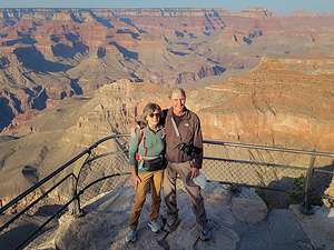 We have arrived!Herb and I hadn’t been to the Grand Canyon since 2002, so we were pretty excited about returning. I mean who wouldn't be excited at the prospect of experiencing the breathtaking beauty and grandeur of this remarkable canyon, attested to by the fact that close to 6 million visitors choose to do so every year.
Since we’ve moved out West 6 years ago, we have visited some of the most beautiful places that this country has to offer, so I wondered whether we would still be “Wowed” by the Grand Canyon. Well, to put it simply, yes and maybe even more so.
When we were planning this trip, we decided to treat ourselves to a night at the iconic El Tovar Hotel, right on the rim, and amortize our lodging expenses by camping the other two nights at Mather Campground.
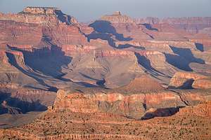 Sunset at Yavapai PointHowever, when we arrived and saw that the nights were dropping down into the low 30s, we wimped out and decided to grab two nights at the Yavapai Lodge, which was located back from the rim a bit, but half the price of El Tovar. I love camping in the 4Runner, but I also love a bathroom and a shower. It definitely seemed like the right thing to do.
The Lodge was great, set in a forest of pines with a large, clean, and comfortable room. Perfect! They even let us check in early. A quick nap and we were ready to start exploring.
Using our tried and true Photographing the Southwest book, I had planned out an itinerary based on the best places to be at sunrise and sunset, and good things to do to fill out that time in between. Tonight the plan was to photograph the sunset at Yavapai Point.
 Sunset at Yavapai PointWe drove our car over to the Visitor Center and from there we walked along the South Rim Trail past Mather Point (also a good spot for sunset) and on to Yavapai Point, considered to be less crowded than Mather Point and with equally great views and orientation to the setting sun.
It was just a little over a mile walk to Yavapai Point, which we discovered was right next to the Yavapai Geology Museum, which was unfortunately closed already. Right next to the museum there was a viewing area that extended out over the canyon a bit, which was fairly crowded with people taking turns photographing the canyon from along the outer wall.
The view was truly stunning from here - wide open to the west with the Plateau Point Trail winding its way down below and a sheer cliff with juniper trees.
 Sunset at Yavapai PointWe waited our turn and took some photos before moving on to a more secluded area just to the right of the official viewing area, where we sat on some rocks just a short step down from the South Rim Trail - but far enough away from the edge to not be worrisome. I had read too many instances of people taking their final selfie too near the edge.
We spent the next hour watching the light change and fill the canyon with brilliant reds and yellow. It truly takes your breath away.
Afterwards we walked back along the South Rim Trail to our car and drove back to the Yavapai Lodge. We both admitted we were so much happier heading back to a warm room and a shower rather than to the back of our 4Runner in the campground.
Early night tonight. Tomorrow the plan was Sunrise and Yaki Point, which was going to require a shuttle to get to.
Day 2 - Sunrise at Yaki Point, South Kaibab Trail hike, and move into El Tovar
 Sunrise at Yaki PointThe South Rim of the Grand Canyon is a pretty busy place, so a shuttle system was put in place a while ago to control the traffic and parking issues that would result if everyone was driving to all the scenic viewpoints. Many of the most exceptional scenic overlooks have now been closed to private vehicles and can only be reached via the shuttle.
It’s really not a problem though, because the shuttles are free, run every 15 minutes, and pretty much take you anywhere around the South Rim that you want to go.
The plan for today was to rise at 4:15, drive over to the Visitor Center, and take the 5:00 am shuttle (Orange line) to Yaki Point, which is one of the scenic overlooks that prohibit private vehicles. I’m not exactly a morning person, but it all went pretty smoothly and wasn’t too traumatic.
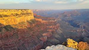 Sunrise at Yaki PointYaki point, like Yavapai Point, is a prime destination for watching the sun rise on the South Rim, with miles and miles of canyon offering layer upon layer of depth to play with light and shadows.
When we got there, there was only one other photographer with a tripod set up in exactly the place we wanted to be. No problem though. There was plenty of spectacular scenery for everyone.
About 15 minutes after our arrival, the sun began to rise between two silhouetted plateaus off to the east, painting the sky in orange and yellow layers.
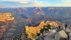 Herb and tripod photographing Sunrise at Yaki PointOnce that show was over, we shifted our position to face west and watched the sun light up the canyon sides in soft reds, yellows, and greens. Not to be corny, but it was truly magical.
We spent some time talking to the other photographer and his wife, a couple named Pavel and Monique from Poland doing a 1 month tour of the American West. It was fun to share in their enthusiasm for the beautiful scenery we were experiencing.
When the sun was done doing its morning show, we took the shuttle back to the Visitor Center, and went back to the Yavapai Lodge where we got in a good hour-long nap before we had to check out. Herb and I congratulated ourselves for our wise decision of staying here where it was warm and comfy rather than camping. We must be getting old.
 Hiking the South Kaibab TrailEnough gazing at the canyon. Time to get down into it, where we could experience its awesome depth firsthand, and surround ourselves on all sides with its massive walls - a much different perspective than viewing from the Rim.
There are two really good trails to hike down into the canyon from the South Rim - the Bright Angel trail, which we had hiked a mile and a half down into the canyon about 20 years ago, and the South Kaibab Trail, which was supposed to provide even more scenic views, if possible.
So off we were again to catch the shuttle (Orange Line) from the Visitor Center to the South Kaibab trailhead. Based on the backpacks and trekking poles associated with our fellow shuttle riders, I don’t think we were the only ones with this plan in mind.
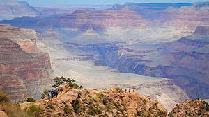 Hiking the South Kaibab TrailI was particularly worried about what appeared to be a class trip of about 20 fourteen year olds, so when the shuttle stopped, I made Herb hurry out to get started on the trail before they did.
The South Kaibab trail is pretty awesome, with several great viewpoints along the way. Unlike most of our hikes which usually climb mountains, this one started at the Rim and went down and down through a series of switchbacks, bringing us down about 1,500 feet in elevation over a mile and three quarters. The downhill is always difficult to totally enjoy, as you know it will turn into a steep uphill on the way back.
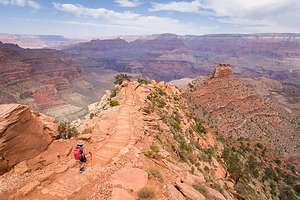 Hiking the South Kaibab TrailAfter three-quarters of a mile, and about a 900 foot loss in elevation, we came to Ooh-Aah Point, where there is a panoramic view both to the west, which was our usual view, as well as towards the infrequently-visited eastern Grand Canyon.
However, somehow the class trip had passed us while we stopped to take photos along the way down, so they were now pretty much in control of Ooh-Aah Point, where they were enjoying a snack while their leader tried to assess whether they wanted to continue on. I have to say their leader was awesome. I certainly didn’t envy any adult responsible for a group of 14-year olds on a hike with some potentially steep drop offs. He did seem to have them very much in control though.
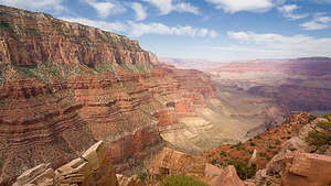 Hiking the South Kaibab TrailSo rather than linger, we forged on continuing our descent to Cedar Ridge, the next suggested viewpoint. I would have to say that our approach to Cedar Ridge was my favorite part of the hike with views below us of the trail which we would follow, seemingly leading off and over to the unknown, and O’Neill Butte just beyond, jutting up from the canyon floor.
When we finally arrived at Cedar Ridge, I thought we were done, but fortunately we had read that there was an outcrop at the far end of the ridge with an even better view into the canyon. They were right.
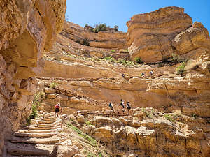 Hiking the South Kaibab TrailCedar Ridge is the turnaround point most day hikers, and it was for us as well. The hike back up to the rim was pretty strenuous - over a 1,400 elevation gain in a mile and a half. A lot of people, some of them even younger than us, were struggling a bit more than we were. Also, the rim was at an elevation of over 7,000 feet and we hadn’t really had time to acclimate to the higher altitude. Still we plugged along at a good pace, and were even complimented for such by a gentleman that was using us a pacers.
The way up wasn’t as scenic because all the good stuff was behind us. However, that gave us a good excuse to stop every once in a while and gaze behind us.
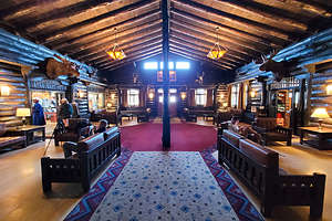 Lobby of El TovarIt was still a little early to check into the El Tovar Hotel, so we had a late lunch/early dinner in the Dining Room. I love National Park Lodges for their rustic, yet elegant ambiance. The Dining Room was constructed of native stone and Oregon Pine, and had murals on the walls reflecting the customs of four Native American Tribes – the Hopi, the Apache, the Mojave and the Navajo.
Many prominent guests, such as Teddy Roosevelt, Paul McCartney, Bill Clinton, and many more, have dined here in the past. The atmosphere alone was enough to make this a positive experience, but the food was good as well. The menu is traditional, integrating both international and local Southwest influences.
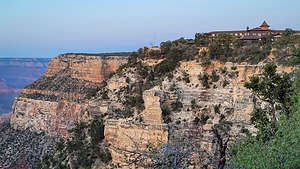 El Tovar, our home for the nightI love National Park Lodges, so I was very excited about our stay at the El Tovar Hotel. Besides its lovely dining room, lounge, and rooms, it definitely had Location, Location, Location - perched directly on the canyon rim.
Finding a place to watch the sunset was easy this time. All we had to do was cross the inviting porch - with a brief testing of a rocking chair - and then stroll along the South Rim trail.
We strolled west along the rim, stopping at benches along the way to take in the scenery. I wanted to find out where the Red Shuttle line, which would take us to Hermit’s Rest (our plan for tomorrow) was, so we continued on for about three quarters of a mile before turning back.
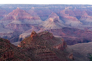 Sunset view from El TovarOn our way back, there was a group of about a dozen people at the top of the Bright Angel Trail whooping and cheering for some runners coming up the trail. We soon figured out what the excitement was about. These runners were just the grueling Rim-to-Rim-to-Rim run, a 47-mile run with over 11,000 feet of elevation gain. I knew this because our son Tommy had accomplished this amazing feat a few years ago. It’s absolutely crazy.
The R2R2R trail starts by a 9 mile descent on the Bright Angel trail. Then runners cross the canyon floor for 7 miles, before hitting the steepest part of the North Kaibab Trail where they climb 7 miles up a 15% - 20% grade to the North Rim. It’s quite an accomplishment.
All we did today was one and a half miles down and then one and a half miles up. I felt like a bit of a weenie.
No early wakeup for sunrise tomorrow. I wanted to sleep in and enjoy every minute of our stay at El Tovar.
Day 3 - Chilling at the El Tovar Hotel and exploring the Hermit’s Rest section of the park
 Hermit's restWe had been moving at a pretty frantic pace since we left home, so we thought a little relaxation would be rejuvenating. Herb chose to load the photos he had taken so far onto his laptop, and I read a book on a bench in the sun overlooking the rim. I think this might have been a trip highlight.
After checking out (so sad), we had lunch again in the El Tovar Dining Room before heading out on our day of exploration along the Hermit’s Rest Road.
Parking in Grand Canyon Village is pretty tough, so we left our car in the El Tovar lot and walked three-quarters of a mile west to the shuttle (Red Line), which would take us to Hermit’s Rest, at the end of Hermit Road. From there our plan was to spend the day walking 8 miles along the rim, arriving at Hopi Point, which is supposed to be one of the best sunset locations on the South Rim.
 Finally we see the riverWe didn’t have to wait long at all for the shuttle, which made nine stops along the way to the very end of the Rim Trail at Hermit’s Rest, where we got off.
Hermit’s Rest is an iconic, historical structure designed by famed architect Mary Colter to resemble an old miner’s cabin with native stonework, a giant alcove fireplace, and a front porch. Today it is a snack bar, so we grabbed a cup of coffee and drank it on the porch.
This is not the only building she designed in the Grand Canyon. She also designed the Hopi House (next to El Tovar), Bright Angel Lodge, Lookout Studio (near the Bright Angel Trail), Desert View Watchtower (along Desert View Drive), and the Phantom Ranch (down by the river). She is definitely the face of man-made (more correctly, female-made) beauty in the park.
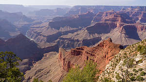 Along the hike from Hermit's RestAs I mentioned, the westernmost end of the South Rim Trail sets out from Hermit’s Rest and extends east for 13 miles to the South Kaibab Trailhead. Today we would do the 7.5 miles from Hermit’s Rest to Hopi Point.
We left Hermit’s Rest around 2:00 pm, which would allow us a leisurely pace to time Hopi Point with sunset.
The first stop along the way was Pima Point, where we caught our first glimpse of the Colorado River as it enters the Granite Gorge rapids.
The next stop was Monument Creek, which I don’t remember much about, but after that came the Abyss, where there was a beautiful view 2,600 feet straight down over sheer cliffs that descend to the Grand Canyon’s Redwall Formation.
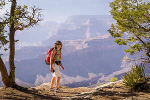 Along the hike from Hermit's RestFrom Mojave Point, we got a glimpse of the river again, 5,000 feet below us. From here you can theoretically see three rapids: Salt Creek, Granite, and Hermit, and possibly even rafts negotiating the whitewater. Unfortunately, we didn’t have binoculars, we could see sections of whitewater.
We arrived at Hopi Point around 6:00 pm, just at the early stages of golden hour. We were not the only ones with the idea of watching sunset from here, but I think we might have been the only ones that earned it by walking all the way from Hermit’s Rest rather than just jumping off the shuttle here.
 Sunset at Hopi PointHerb positioned his tripod up against the rail where no one could get in front of him and waited. From here there was an excellent, although distant, side view of Wotan’s Throne and Vishnu Temple.
At this time of day, the shuttle doesn’t make a stop at Hopi Point, so we had to walk a short distance to Powell Point, where the shuttle back to Grand Canyon Village would stop.
From the Grand Canyon Village, we walked back to the El Tovar parking lot where we had left our car, and drove over to the Yavapai Lodge where we had booked a room.
Day 4 - Drive Desert View Drive and continue on towards Monument Valley
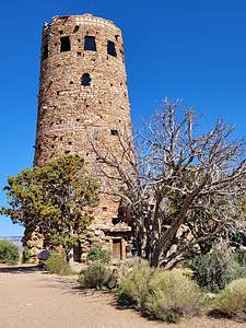 Mary Colter's Desert View WatchtowerOur drive east towards Monument Valley took us along the very scenic Desert View Drive, which follows the rim for about 22 miles from Grand Canyon Village to Desert View and the East Entrance to the park.
We were anxious to get on to new scenery so we made only two quick stops along the way. The first was Moran Point, which is the closest location to two of the most recognizable landmarks in the canyon - Vishnu Temple and Wotan’s Throne.
Our next stop was to see another one of Mary Colter’s creations: the Desert View Watchtower. Often referred to as the architect of the southwest, the architecture of the ancestral Puebloan people served as her model. The Desert View Watchtower was patterned after the Round Tower of Mesa Verde.
The Tower, which blends into the rock of the canyon walls, exemplifies her belief in designing buildings that would become part of its surroundings. It reminded me of Frank Lloyd Wright’s philosophy in his design of Falling Water.
From here we said our goodbyes to the Grand Canyon and continued on towards Monument Valley.
- ‹ previous
- 2 of 9
- next ›
Grand Canyon - South Rim location map in "high definition"
Javascript is required to view this map.
