- Home
- About
- Map
- Trips
- Bringing Boat West
- Migration West
- Solo Motorcycle Ride
- Final Family XC Trip
- Colorado Rockies
- Graduates' XC Trip
- Yosemite & Nevada
- Colorado & Utah
- Best of Utah
- Southern Loop
- Pacific Northwest
- Northern Loop
- Los Angeles to NYC
- East Coast Trips
- Martha's Vineyard
- 1 Week in Quebec
- Southeast Coast
- NH Backpacking
- Martha's Vineyard
- Canadian Maritimes
- Ocracoke Island
- Edisto Island
- First Landing '02
- Hunting Island '02
- Stowe in Winter
- Hunting Island '01
- Lake Placid
- Chesapeake
- Provincetown
- Hunting Island '00
- Acadia in Winter
- Boston Suburbs
- Niagara Falls
- First Landing '99
- Cape Hatteras
- West Coast Trips
- Burning Man
- Utah Off-Roading
- Maui
- Mojave 4WD Course
- Colorado River Rafting
- Bishop & Death Valley
- Kauai
- Yosemite Fall
- Utah Off-Road
- Lost Coast
- Yosemite Valley
- Arizona and New Mexico
- Pescadero & Capitola
- Bishop & Death Valley
- San Diego, Anza Borrego, Joshua Tree
- Carmel
- Death Valley in Fall
- Yosemite in the Fall
- Pacific Northwest
- Utah Off-Roading
- Southern CA Deserts
- Yosemite & Covid
- Lake Powell Covid
- Eastern Sierra & Covid
- Bishop & Death Valley
- Central & SE Oregon
- Mojave Road
- Eastern Sierra
- Trinity Alps
- Tuolumne Meadows
- Lake Powell Boating
- Eastern Sierra
- Yosemite Winter
- Hawaii
- 4WD Eastern Sierra
- 4WD Death Valley +
- Southern CA Deserts
- Christmas in Tahoe
- Yosemite & Pinnacles
- Totality
- Yosemite & Sierra
- Yosemite Christmas
- Yosemite, San Diego
- Yosemite & North CA
- Seattle to Sierra
- Southwest Deserts
- Yosemite & Sierra
- Pacific Northwest
- Yosemite & South CA
- Pacific Northwest
- Northern California
- Southern Alaska
- Vancouver Island
- International Trips
- Index
- Tips
- Books
- Photos/Videos
- Search
- Contact
Chaco Canyon, NM
Thursday, May 5, 2022 - 8:15am by Lolo
75 miles and 1.5 hours from our last stop - 1 night stay
Travelogue
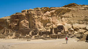 Chaco Canyon - Pueblo BonitoThis was turning out to be an educational journey about ancient and current day Native American cultures. Monument Valley, Canyon de Chelly, and Shiprock are all part of the current Navajo Nation although their past dates back to the Puebloan.
Chaco Canyon is a little different in that it is not part of a current day reservation and no one lives there today. In fact, there is even some question as to whether anyone ever lived there at all, or whether this was just a site for large spiritual gatherings. The lack of middens (prehistoric refuse heaps where archeologists sift through evidence of human occupancy) and burials (only 13 burials uncovered) does not seem to support the theory that a large community lived here.
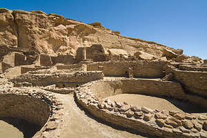 Chaco Canyon - Pueblo BonitoSo there is lots of mystery surrounding Chaco Canyon.
What is known is that beginning around the mid-800s, Chaco people began building here, creating multi-story stone buildings on a grand scale. For the next 300 or so years, they quarried sandstone blocks and hauled timber from great distances to build fifteen major complexes, which remained the largest buildings ever built in North America until the 1800s.
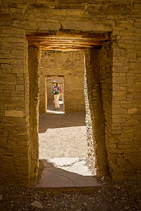 Inside Pueblo BonitoBetween 850 and 1130 CE, Chaco Canyon was a major hub for trade, administrative and ceremonial life, a meeting place where Ancestral Puebloan people living in distant communities came to at certain times of the year to gather together for what probably were religious ceremonies.
Then, around 1130 CE, the canyon was pretty much abandoned with the onset of a fifty-year drought.
Today Chaco Canyon is a World Heritage Site, as it remains one of the most impressive archaeological sites in the world. Tens of thousands of visitors come here every year, despite its remote location and need to drive miles and miles on bumpy dirt roads to reach it.
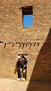 Doors pretty small in Pueblo BonitoChaco Canyon can pretty much be explored in a day. There is a nine-mile Canyon Loop drive with stops along the way to visit the various ruins: Una Vida, Hungo Pavi, Pueblo Bonito, Chetro Ketl, Pueblo del Arroyo, and Casa Rinconada.
There are also a few hikes, the most popular one being the 5.2-mile Pueblo Alto Loop, where there is a wonderful overlook of Pueblo Bonito (the most impressive of the Canyon’s ruins).
We were so well prepared for this stop. I am a bit of a nerd and I made Herb listen to an hour of lectures on the Chacoan Culture and watch a documentary called “The Mystery of Chaco Canyon” narrated by Robert Redford.
A lot of the “mystery” surrounding Chaco Canyon includes:
What is the real purpose of this huge complex since it didn’t seem to serve as a residence?
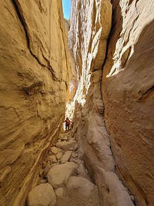 Climbing the slot to start the Palo Alto LoopWhy did they build wide roads extending out from it, like spokes on a wheel, that seemed to go nowhere?
What was the role that astronomical observations played in their culture? There was definitely a strong interest (and incredible knowledge) in lunar and solar cycles, and many buildings are oriented to align with the winter and summer solstices.
I don’t think we are going to solve those questions today, but I am glad we learned so much before coming here, because it definitely made our visit more interesting and thought provoking.
Our first stop along the drive was the parking area for Pueblo Bonito, and Chetro Ketl, considered to be the best and most interesting of the ruins.
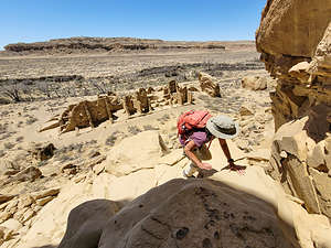 Starting up the Pueblo Alto trailWe headed first towards Pueblo Bonito, the oldest and largest, as well as best preserved, of the ruins. It is massive, covering over 3 acres and containing 800 rooms.
The entire complex, which is in the shape of a “D,” is divided into two sections by a precisely aligned wall which runs north to south through a central plaza. There is a giant kiva on either side of the wall, creating a symmetrical pattern. There are 30 other kivas in the complex, but the two Great Kivas were probably used for large religious ceremonies, more evidence that this site was used as a ritual center rather than a residence.
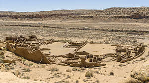 View of Pueblo Bonito from aboveIn places, the ruins were five storeys high with hundreds of rooms enclosed by elaborate brickwork and windows, with interior doorways connecting the rooms. We were delighted to find that we could wander on our own through some of its rooms.
The doorways were the most intriguing. When we stood in just the right place, they lined up to give the impression that you can see all the way through the building through multiple doors.
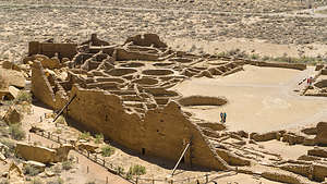 Closeup of Pueblo Bonito from aboveAfter exploring all the rooms that we were allowed to, we decided to do the Pueblo Alto hike, where we would be able to see the whole Pueblo Bonito complex below us in all its grandeur.
Here’s where I made a big mistake. I mistakenly thought that parking at the Pueblo Bonito parking lot would lead us to the trailhead for the hike whose highlight was the Pueblo Bonito Ruins. As a result, Herb and I kept scanning the cliffs behind Pueblo Bonito to see where we could climb up. I mean, we don’t mind a little rock scrambling, but this looked impenetrable.
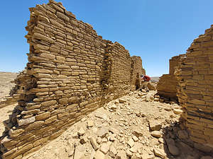 Peeking through the ruins at Pueblo NuevoFinally, we looked at Gaia and saw that the trailhead was actually from the Pueblo del Arroyo parking lot, so we just forged on to that, basically adding almost 2 miles (now and on our way back) to our 5.2-mile hike. That’s a pretty big % off in hike length.
Even then, the trailhead was hard to find until we realized it was a narrow crevasse up the cliff that required a bit of rock scrambling. It was fun! For the purposes of the description of this hike, I will state the mileage from the real start of the trail rather than ours.
From atop the plateau, we followed the trail along the riml, nicely marked by rock cairns, across slickrock along the edge of the mesa. At 0.6 miles we came across some perfectly round basins (about 10 inches across) carved into the slickrock. They were called "pecked basins." We guessed that they must have been used for grinding something.
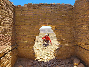 Pueblo NuevoAfter about 1 mile we came to the junction with the Pueblo Bonito Overlook trail. This short spur trail goes to the mesa rim right above Pueblo Bonito at 1.1 miles. The bird’s-eye view of this Great House is really amazing and offers a much greater appreciation of its massiveness and grandeur.
From there we had a choice, although many people just choose to turn around at this point making it a 2-mile RT. We, however, were going all the way.
We decided to do the loop clockwise, so we headed north (away from the rim) towards New Alto and Pueblo Alto for about a mile. We ascended a wide dirt trail, which pointed out a section of Chacoan steps along a slickrock ramp that was part of a Chacoan Road.
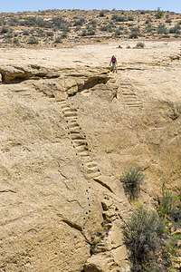 Chacoan StairwayWe came first to the two-story New Alto structure, which was built around 1100 CE. The ruin contained 58 rooms arranged around a kiva. The structures have been stabilized but not excavated.
Next we arrived at the Pueblo Alto complex, which is composed of six structures, only four of which are visible. Pueblo Alto is the largest of the ruins on the rim and the only one that has been excavated. Unlike the other multi-story Great Houses in Chaco, Pueblo Alto, which was built from 1020 - 1050, was only one story. Oddly, there is no kiva in the complex. Archaeologists have found evidence of four roads from the north that converge at Pueblo Alto as do roads from Chetro Ketl, Pubelo Bonito and Penasco Blanco.
Unlike Pueblo Bonito, which had undergone excavation and reconstruction, these were true unrestored ruins - an interesting contrast to the Pueblo Bonito and Chetro Keti - very eerie and remote.
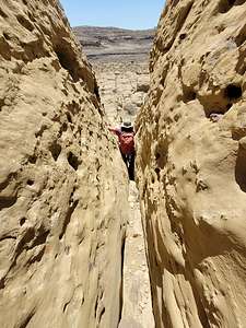 Squeezing my way through a slotFrom here, many people turn back, making for a 3.8-mile out-and-back hike. We, however, continued on, heading east. In about a mile we caught sight of the Chacoan Stairway, which I am embarrassed to admit was another uninformed miscalculation on my part. For the entire hike so far, I held onto the belief that we did not have to go totally back to the rock scramble down the crevasse by Pueblo del Arroyo.
And how did I think I was going to do that? On the Chacoan Stairway, of course, which according to Gaia was coming up soon. Herb did not hold this same belief, and enjoyed my reaction far too much when they came into view. They called these tiny nitches carved into what was practically a vertical wall a Stairway?? I couldn’t even get myself close enough to the edge to see the first one I was supposed to step on. Actually, I, nor anyone else born in this millennium was supposed to step on them.
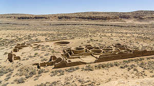 View of Chetro Ketl from aboveThey were artifacts from the Ancient Puebloans built roads coming from the Great Houses in exactly straight lines. They didn’t care what got in their way. If the topography went straight up, so did the stairs. Sometimes, as in this case, they were wise enough to carve handholds along the side of them.
Looks like we had some more miles to go.
The trail now turned right (south) and we proceeded back towards the rim descending the mesa. At one point we were a bit stymied as to which way we were to go, but then we found a marker indicating where the trail went down a narrow slot between two large boulders, bringing us to the next bench on the mesa.
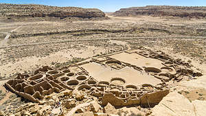 Another look at Pueblo Bonito from aboveFrom here we began heading west. Soon we came to a great viewpoint directly above Chetro Ketl, the second largest of the Great Houses of Chaco Canyon. From here we could see the internal rooms, a great kiva, and an elevated plaza with more kivas.
From there we just kept heading west. At one point, we looked straight down into the parking lot where our car was parked, but there wasn’t a Chacoan Stairway in sight, so we forged on, stopping once again at the Pueblo Bonito Overlook before finally scrambling down the narrow crevasse back to the trailhead.
.thumbnail.jpg) Back at Pueblo BonitoFinally, back at the car, Herb pointed out that we had managed to turn a 5.2-mile hike into a 9-mile one. Oops.
Back at Pueblo BonitoFinally, back at the car, Herb pointed out that we had managed to turn a 5.2-mile hike into a 9-mile one. Oops.
It was already 4:00. We were tired and didn’t know yet where we were staying for the night, so we completed the Canyon Loop Drive and then started heading southwest towards I40, along about 30 miles of bumpy dirt roads before finally hitting the pavement of Highway 371.
We figured Gallup would be a good place to stop for the night, so we found a Best Western in the center of town, right off historic Route 66.
We struck gold when we asked the hotel concierge for a recommendation for dinner. He pointed us right across the street to the El Rancho Hotel.
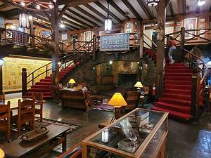 Historic El Rancho Hotel in GallupDuring its heyday, the El Rancho Hotel was one of the premier hotels in the entire Southwest, and in the 1930s and 40s it became the place for the Hollywood set to stay when filming in the area. Some of the movie stars that stayed there include: Jane Fonda, Humphrey Bogart, Katharine Hepburn, Lucille Ball, Gregory Peck, Betty Grable, Kirk Douglas, Robert Mitchum, John Wayne, Jimmy Stewart, Doris Day, and Rita Hayworth.
The lobby was beautiful - dark wood, colorful navajo rugs, a large fireplace, and practically a museum of movie memorabilia on the walls.
Dinner was good and since it was Cinco de Mayo, of course we just had to have a Margarita.
Nice way to cap off a great day and a great vacation. Tomorrow we would start heading home.
- ‹ previous
- 8 of 9
- next ›
Chaco Canyon location map in "high definition"
Javascript is required to view this map.
