- Home
- About
- Map
- Trips
- Bringing Boat West
- Migration West
- Solo Motorcycle Ride
- Final Family XC Trip
- Colorado Rockies
- Graduates' XC Trip
- Yosemite & Nevada
- Colorado & Utah
- Best of Utah
- Southern Loop
- Pacific Northwest
- Northern Loop
- Los Angeles to NYC
- East Coast Trips
- Martha's Vineyard
- 1 Week in Quebec
- Southeast Coast
- NH Backpacking
- Martha's Vineyard
- Canadian Maritimes
- Ocracoke Island
- Edisto Island
- First Landing '02
- Hunting Island '02
- Stowe in Winter
- Hunting Island '01
- Lake Placid
- Chesapeake
- Provincetown
- Hunting Island '00
- Acadia in Winter
- Boston Suburbs
- Niagara Falls
- First Landing '99
- Cape Hatteras
- West Coast Trips
- Burning Man
- Utah Off-Roading
- Maui
- Mojave 4WD Course
- Colorado River Rafting
- Bishop & Death Valley
- Kauai
- Yosemite Fall
- Utah Off-Road
- Lost Coast
- Yosemite Valley
- Arizona and New Mexico
- Pescadero & Capitola
- Bishop & Death Valley
- San Diego, Anza Borrego, Joshua Tree
- Carmel
- Death Valley in Fall
- Yosemite in the Fall
- Pacific Northwest
- Utah Off-Roading
- Southern CA Deserts
- Yosemite & Covid
- Lake Powell Covid
- Eastern Sierra & Covid
- Bishop & Death Valley
- Central & SE Oregon
- Mojave Road
- Eastern Sierra
- Trinity Alps
- Tuolumne Meadows
- Lake Powell Boating
- Eastern Sierra
- Yosemite Winter
- Hawaii
- 4WD Eastern Sierra
- 4WD Death Valley +
- Southern CA Deserts
- Christmas in Tahoe
- Yosemite & Pinnacles
- Totality
- Yosemite & Sierra
- Yosemite Christmas
- Yosemite, San Diego
- Yosemite & North CA
- Seattle to Sierra
- Southwest Deserts
- Yosemite & Sierra
- Pacific Northwest
- Yosemite & South CA
- Pacific Northwest
- Northern California
- Southern Alaska
- Vancouver Island
- International Trips
- Index
- Tips
- Books
- Photos/Videos
- Search
- Contact
Yosemite - Tuolumne Meadows, CA
Thursday, July 21, 2016 - 2:00pm by Lolo
57 miles and 1.5 hours from our last stop - 4 night stay
Travelogue
Arrival and an evening walk in the meadow
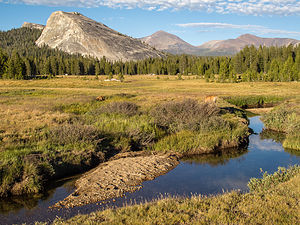 Tuolumne Meadows with Lembert DomeOn Thursday morning, as planned, we left the Valley and drove the highly scenic, one and a half hour drive along the Tioga Pass Road to our new Yosemite base camp in the Tuolumne Meadows Campground, where we fortunately had managed to get not just one, but two campsites.
Reserving a Yosemite campsite is a very stressful event, as they disappear within minutes of the start of the booking window on Recreation.gov. Herb and I literally train and practice on the website the night before. The National Park Service even devotes a page on their website to tips on how to increase your chances of booking a site:
http://www.recreation.gov/marketing.do?goto=acm/Explore_And_More/explore...
Tuolumne was where the boys really wanted to climb, since the Valley is just too hot in the summer – although they did manage to find some shady walls while they were there last weekend. Temperature decreases about 3.5 degrees Fahrenheit for every 1,000 feet in elevation, so at an altitude of 8,600 feet, Tuolumne is about 15 degrees cooler. That’s also why its season is so short. The Tioga Pass Road usually closes due to snow as early as late October / early November and doesn’t reopen again until Memorial Day.
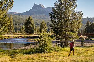 Lolo in Meadow with Cockscomb in distanceTuolumne also looks and feels a lot different than the Valley. Both have beautiful meadows with rivers running through them, but Tuolumne’s meadow is surrounded by dozens of glacially-carved granite domes rather than the steep, dramatic granite walls that enclose the Valley. It’s also a lot less crowded and, as a result, more peaceful and serene.
Herb and I have been to Tuolumne several times, but for some reason we had never explored the meadow in any depth. For preservation reasons, you are not allowed to just wander aimlessly across the meadow, but must stay on the trail, which is accessible from either across the road from the Visitor Center or from the Lembert Dome parking lot.
We started on the trail by the Visitor Center, and in about a 1/2 mile crossed a footbridge over the river, where we were treated to lovely views of Cathedral Peak, Unicorn Peak, the Cockscomb, and Echo Peaks to the south and Lembert Dome to the north. There was even a fly fisherman wading in the river, making the scene even more idyllic.
 Soda SpringsA short distance past the bridge, we turned left towards the Parsons Memorial Lodge, a rustic structure built entirely from local logs and granite by the Sierra Club in 1915. It was named for Edward Taylor Parsons, who was the club’s director for 10 years and heavily involved, along with John Muir, in the unsuccessful fight to save Hetch Hetchy. The Club used it as a meeting house and library.
Today the Lodge is used to hold the Tuolumne Meadows Summer Series of lectures by renowned photographers, writers, musicians, storytellers, and environmentalists. It’s nice to know that it is still being used to inspire visitors to appreciate these wonderful surroundings and to instill a need for stewardship to protect them.
Just above the Lodge stands the old wooden McCauley Cabin, built by John McCauley in 1912. Today it is used to house park personnel. An interesting tie-in between this cabin and the Parsons Lodge is that the founder of the Parsons Lodge Summer Series, Margaret Eissler, lived in the McCauley Cabin for several summers when her parents were caretakers. There is even a picture of her as a little girl standing in front of the cabin with her family.
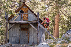 Lolo playing pioneer near old McCauley CabinThere was another wooden structure behind the McCauley cabin for which I don’t know the history. However, I did have fun climbing the ladder up to its balcony.
We retraced our steps back to the junction for Parsons Lodge and Soda Springs, and continued a short distance to another historic structure - the Soda Springs Cabin, a small log cabin built by John Baptiste Lembert over a bubbling, naturally carbonated spring. A surprising fact is that geologists have no idea how or why the springs formed.
It was here that I learned that Lembert was not just the name of a dome, but of the first white settler in the Tuolumne Meadows, who in 1885 filed a claim for 160 acres. He must have been pretty lonely living out here alone each summer tending his goats. In 1889 he built the structure over the spring to keep the animals out.
Herb and I took turns bending down through the doorway of the cabin to touch the spring water, which was cooler than expected – each of us smacking our heads in the beam over the doorway on our way out. Perhaps Lembert was trying to keep tourists out as well.
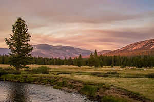 Sunset in Tuolumne MeadowBesides playing with his goat herd, Lembert gained fame as a guide and naturalist throughout the Tuolumne region, being the sole resident there in the summer and wintering in a small cabin near Cascade Creek in Yosemite Valley. Tragically, he was murdered in this cabin in 1897, apparently for a small amount of money.
This hike had been so interesting. The only thing I love more than pristine, natural beauty is having some history thrown in. Add a good cocktailing venue along a river to that and you have the makings of a perfect evening.
Receiving our guests and redoing the meadow experience
Herb and I did something we do not normally do in Yosemite – just relaxed and read in our campsite. It’s nice that we have been here so often that we don’t feel compelled to run around like tourists every minute.
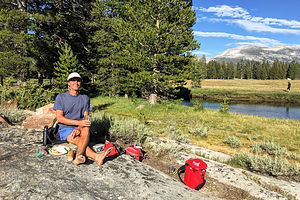 Cocktail hour in Tuolumne MeadowAlso, Andrew, Tommy, Celeste, and her parents were arriving later this afternoon, and we wanted to make sure we were there to greet them.
After they arrived and set up their campsites, we packed a cooler with hors d'oeuvres and wine and walked back to the meadow. Herb and I had had such a wonderful experience last night that we wanted to share this beautiful place with them.
Sitting along the river’s edge identifying Cathedral Peak, Unicorn Peak, the Cockscomb, and Lembert Dome was a great orientation to Tuolumne Meadows.
Hiking to Sunrise Lakes, Swimming in Tenaya Lake, Bouldering, and Celebrating Tommy’s Birthday
Normally, the agenda for the day would be climbing, but since Celeste’s parents were along, we decided to do something more inclusive, like a hike.
We chose the Sunrise Lakes hike because it was about the right length (8.5 miles), right level of difficulty (elevation gain of 1,700 feet), and right scenery (three alpine lakes and awesome views).
 View along the Sunrise Lakes HikeThis trail also shares the first 3 miles with the trail to Clouds Rest, a truly classic and challenging 14-mile RT hike that is supposed to be one of Yosemite’s best. Today would be a good test to see if my poor blistered feet would be able to handle such a hike later in the week.
The hike begins near Tenaya Lake’s southwest shore. Since this was a Saturday and we were attempting a very popular hike from a very popular destination, the parking lot was already full and cars were parked for quite a distance along the side of Tioga Pass Road. Fortunately, we were able to get a spot not too far from the trailhead.
The trail started out easy, but at about 1.5 miles into the hike, we began to climb quite steeply through a series of switchbacks up a rocky slope, where we gained about 1,000 feet in one mile. Finally, we reached the top of the ridge and came to a trail junction – straight ahead 4.7 miles to Clouds Rest or left to Sunrise Lakes.
I could see that everyone was toying with the idea of forging on to Clouds Rest, but we really had started too late to do another steep 4.7 miles just to get to Clouds Rest and then another 7.2 back to the car. My feet were silently voting no. Everyone decided that we should continue with the original plan of hiking to the lakes.
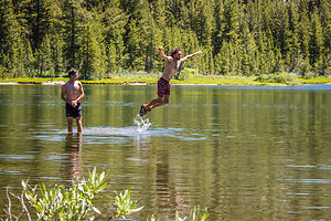 Swimming in Upper Sunrise LakeBefore making the left, we took a short, unsigned trail to the right for a breathtaking view of Half Dome, Tenaya Canyon, and Yosemite Valley. Thankfully, somebody told us about this spur trail, because missing it would have been a shame. It was by far the best view along the trail.
Back on the main trail, we passed the first of the three lakes in about ½ mile and what we thought was the second in another ½ mile. It looked quite inviting, so we stopped for lunch and a swim.
The lake, which was surrounded by pine trees and granite outcropping was quite pretty, but not nearly as dramatic a setting as Cathedral Lake with Cathedral Peak as a backdrop, which we had hiked to last year.
That didn’t stop the kids from enjoying a refreshing swim out to a rock, submerged just enough under the surface to make it looked like they were walking on water.
On the way back, we found the third lake, which was really the second lake, about a hundred yards off the trail, hidden by trees.
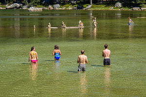 Cairn sculptures in Tenaya LakeThis is an out-and-back trail, so we retraced our steps down the steep, rocky switchbacks back to Tenaya Lake, which with its glacial blue waters and surrounding granite domes, has to be one of the most beautiful lakes in the Sierras.
Our cars were parked just down the road, so we grabbed beach chairs and towels and spent the next two hours perched on a rocky ledge along the shore, where we could gracefully enter the water for a swim.
I don’t know if I would exactly call what we did swimming, because the water was too shallow, but we did wade out to a rocky shoal about 100 yards off the shore, where people had created quite an interesting display of cairns. Since we had brought along our own personal artists (Hilda and Paul were both graduates of the San Francisco Art Institute), we decided to have a go at creating our own. I felt that I could best contribute as a gatherer of rocks while they did the artsy stuff. I wish we had gotten a photo of our handiwork, but it blew down with a big wind before we got back to our cameras on the shore.
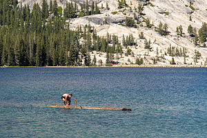 Tommy log rolling in Tenaya LakeMeanwhile, Tommy had commandeered a huge log floating across the lake and decided to try his hand at log rolling. In hindsight, one should not attempt this feat for the first time on a log with pointy broken branches sticking out of it. It’s kind of like using flaming torches the first time you try to juggle. When he returned to shore, we applied Neosporin and a bandage to the big scrape he got along the inside of his thigh.
Feeling refreshed and recharged, the kids headed out ahead of us to go bouldering on the Tenaya East Boulders, just a short drive to the eastern end of the lake. They gave us precise directions (including GPS coordinates) to find them later, which turned out to be unnecessary, since we could actually see them from the road.
Herb and I have watched them boulder many times, but I think this was one of the first times that Hilda and Paul saw their tenacious daughter in action. I think they were amazed and rightly proud.
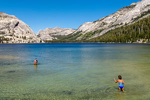 Tenaya LakeWe didn’t stay too late because this was Tommy’s birthday, and we wanted to get back to the campsite early enough for Tommy’s birthday feast – the Ahwahnee Brunch last weekend was just practice. Paul and Hilda are great. Not only did they volunteer to bring the meat (as we had been away from grocery stores for a week), but they selected Tommy’s favorite meal – flank steak (or cow, which he used to call it when he was 4). Needless to say, it was – as are all meals that Paul and Hilda have a hand in -- delicious.
Hiking to the top of Lambert Dome while the kids climb it and meet us at the top
Lembert Dome is the most iconic of Tuolumne’s domes and the one we had been admiring from afar on our evening strolls through the meadow. Today we would pay it proper homage by reaching its summit, which loomed 800-feet above the meadow.
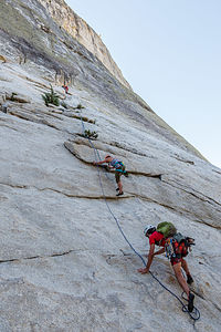 First pitch on Lembert DomeLike most domes, Lembert Dome has a steep face, which rock climbers like to play on, and a gentler, yet still steep, backside that hikers can scramble up. Today, we would split up into two groups. Hilda, Paul, Herb, and I would hike to Dog Lake and then up the backside of the dome, while Andrew, Tommy, and Celeste would take the more vertical approach and rock climb to its summit, where we would meet up for lunch. Family picnics have certainly changed over the years.
Rather than deal with parking, we loaded up our gear for the day and hiked about a mile to the western, steeper side of Lembert Dome, where they would begin their climb up a classic 5.10c route called Direct Northwest Face. We all went up to the base of the climb to watch them get started, before continuing on our hike.
This was a “trad”, rather than a “sport” climb, which was a bit more involved in that rather than having permanently fixed bolts already placed in the rock to clip into, the “lead” climber has to put his own pieces of protection in as he (or she) ascends. That is rather a gross simplification of what is involved, but it’s the general idea.
We watched Tommy lead the first pitch, before setting off on our hike. They told us to take our time, as it would probably take them about 3 to 4 hours to reach the summit.
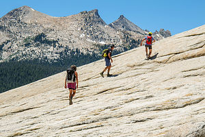 Back side of Lembert DomeAbout ½ mile after leaving the kids, we came to a trail junction – Dog Lake 0.4 miles straight ahead, backside of Lembert Dome 0.5 miles to the right. Since we had plenty of time to kill, we went towards Dog Lake, another one of the Sierra’s lovely alpine lakes.
Once at the lake, we continued on an obvious path along the western (left) shore, admiring the views of Mount Gibbs and Mount Dana in the distance to the east. The entire walk around the lake was just a little over a mile.
From the lake, we hiked back down to the trail junction we had passed earlier, took a left turn towards Lembert Dome, and after a half mile came to a sign pointing us to the right to ascend the backside of the dome. There is no official path to the top, so you have to figure out your own way up the steep granite slabs.
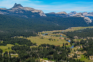 View from atop Lembert DomeAlthough a little bit intimidating, it was nothing compared to going up the backside of Half Dome. There it is so steep that they have installed cables to hold onto as you ascend. Still even on this dome, your heart does get pumping, and not just from the physical exertion.
When we got to the summit, it was pretty windy, so we found a sheltered area behind a rock and waited for the kids finish the climb. In the meantime, we just sat back and enjoyed the wonderful panoramic view - Cathedral Range to the South, the Sierra crest to the east, and Tuolumne Meadows to the west.
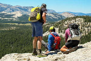 Awaiting our climbersWe soon realized that we weren’t really sure where along the dome their climb ended. The top of the dome is pretty expansive, so Herb and Paul took an exploratory walk along the side they would be coming up to see if they could see them. Not yet. It was still only about 2 ½ hours since they started and they said it would probably take 3 or 4.
Pretty much on time, we spotted Tommy’s blue helmet down below. Soon all three of them came into view. Paul and Hilda had not seen Celeste climb that often, so I think the sight of her climbing towards them, with the ground hundreds of feet below, was pretty exciting for them. It was pretty exciting for me and Herb as well. Although we have watched them climb dozens of times, we had never watched from this vantage point.
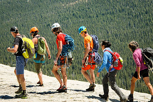 Reunited atop Lembert DomeAfter our family picnic, we walked down the steep backside of the dome and back to the campground. It was already late afternoon on Sunday, so the kids packed up and headed back to the city, while the retirees strolled out to the meadow once more to enjoy another incredible sunset.
The next morning, Paul and Hilda headed back home to Sonoma County, and Herb and I continued eastward to Mono Lake.
Description
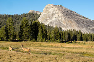 Deer frolicking in the meadowIn my past Yosemite National Park trip stop descriptions, I have focused on Yosemite Valley. However, this time our foray into Yosemite included a few days in beautiful Tuolumne Meadows along the Tioga Pass Road in the northern part of the park.
Tuolumne Meadows is very different from Yosemite Valley. At an altitude of 8,600 feet, it is high country and therefore, considerably cooler and wetter. As its name implies, Tuolumne is a beautiful sub-alpine meadow along the Tuolumne River, surrounded by rugged snow-covered mountain peaks and glacially-carved granite domes. The rock is porphyritic granite, which has a tendency for exfoliation, resulting in the distinctive dome shapes that are found here.
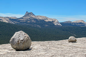 Atop Lembert DomeHiking and rock climbing are extremely popular in this section of the park and tend to be much less crowded than the Valley. In contrast to the big walls in the Valley, the rock climbing routes on the major domes in the Meadow are shorter.
There are very few services in Tuolumne and the Tioga Pass Road is usually only open from Memorial Day through late October / early November, depending on the snowfall. During the summer (mid-June to mid-September), camping is available at Tuolumne Meadows Campground. It is extremely popular, so reservations are strongly recommended. However, there are also many sites saved as first-come-first-served. There is also a small grocery store, grill, post office, and gas station.
- ‹ previous
- 2 of 5
- next ›
Yosemite - Tuolumne Meadows location map in "high definition"
Javascript is required to view this map.
