- Home
- About
- Map
- Trips
- Bringing Boat West
- Migration West
- Solo Motorcycle Ride
- Final Family XC Trip
- Colorado Rockies
- Graduates' XC Trip
- Yosemite & Nevada
- Colorado & Utah
- Best of Utah
- Southern Loop
- Pacific Northwest
- Northern Loop
- Los Angeles to NYC
- East Coast Trips
- Martha's Vineyard
- 1 Week in Quebec
- Southeast Coast
- NH Backpacking
- Martha's Vineyard
- Canadian Maritimes
- Ocracoke Island
- Edisto Island
- First Landing '02
- Hunting Island '02
- Stowe in Winter
- Hunting Island '01
- Lake Placid
- Chesapeake
- Provincetown
- Hunting Island '00
- Acadia in Winter
- Boston Suburbs
- Niagara Falls
- First Landing '99
- Cape Hatteras
- West Coast Trips
- Burning Man
- Utah Off-Roading
- Maui
- Mojave 4WD Course
- Colorado River Rafting
- Bishop & Death Valley
- Kauai
- Yosemite Fall
- Utah Off-Road
- Lost Coast
- Yosemite Valley
- Arizona and New Mexico
- Pescadero & Capitola
- Bishop & Death Valley
- San Diego, Anza Borrego, Joshua Tree
- Carmel
- Death Valley in Fall
- Yosemite in the Fall
- Pacific Northwest
- Utah Off-Roading
- Southern CA Deserts
- Yosemite & Covid
- Lake Powell Covid
- Eastern Sierra & Covid
- Bishop & Death Valley
- Central & SE Oregon
- Mojave Road
- Eastern Sierra
- Trinity Alps
- Tuolumne Meadows
- Lake Powell Boating
- Eastern Sierra
- Yosemite Winter
- Hawaii
- 4WD Eastern Sierra
- 4WD Death Valley +
- Southern CA Deserts
- Christmas in Tahoe
- Yosemite & Pinnacles
- Totality
- Yosemite & Sierra
- Yosemite Christmas
- Yosemite, San Diego
- Yosemite & North CA
- Seattle to Sierra
- Southwest Deserts
- Yosemite & Sierra
- Pacific Northwest
- Yosemite & South CA
- Pacific Northwest
- Northern California
- Southern Alaska
- Vancouver Island
- International Trips
- Index
- Tips
- Books
- Photos/Videos
- Search
- Contact
South Lake Tahoe Area, CA
Thursday, July 28, 2016 - 2:30pm by Lolo
120 miles and 3 hours from our last stop - 2 night stay
Travelogue
 Camp Richardson Beach on Lake TahoeThere are many ways to drive back to Sonoma County from the Eastern Sierras,, but all of them involve a mountain pass of some sort – Tioga Pass, Sonora Pass, Monitor Pass, etc. Although still somewhat exciting, we have found that going north on 395 to Minden, Nevada, and then back south a bit through Luther Pass is the lesser of evils in terms of steepness and lengths of grades – and it has the added benefit of bringing us to South Lake Tahoe.
Our destination in South Lake Tahoe was Camp Richardson, a lakeside resort with RV camping, lodging, a full-service marina, and restaurant on the water. It was quite nice and really in the heart of things.
It was already late afternoon, so we loaded up the cooler with cheese and crackers and wine, and walked the short distance to a lovely beach on Tahoe’s southern shoreline. Before settling in to cocktail hour, I went for a 5 mile run along the paths through the nearby Tallac Historic site, which we had discovered on our visit here last year. As I have mentioned in so many previous posts, I love historical sites, especially those that let you step back in time for a vicarious peek into what life was like in a different time and place.
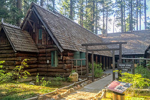
It was fun running past the beautiful old summer “cottages” built by three socially prominent San Francisco families back in the early 1900s and lovingly preserved by the Tahoe Heritage Foundation and the U. S. Forest Service. On certain days and times, the Baldwin Estate, Pope Estate, and Valhalla are open for public tours.
 Tallac Historic SiteI rejoined Herb on the beach where we enjoyed sipping wine and watching sunset over the mountains by Emerald Bay.
After dinner in the RV, I persuaded Herb to go for a walk in the dark through the Tallac Historic site, which we had done last year. Although they are called “estates,” they are actually rustic wooden lake houses with wraparound porches, complete with rocking chairs. And the best part of all is that you are allowed to wander onto the porches, peek in the windows, and even sit in the rockers. I’m surprised that there was no one else doing the same thing. It felt like we owned the place. It was so very cozy and peaceful.
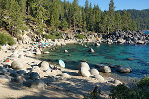
The next morning we drove up to Secret Cove, one of a series of secluded, pristine beaches along Highway 28 on the remote Nevada eastern shore of the lake. It is one of Herb’s favorite beaches, which means a lot coming from a beach aficionado, so we come back to it every time we are in the area.
Along this section of the lake, the highway is way above the lake, so we had to hike down a fairly long, steep path to the beach, lugging our beach chairs, cooler, and tubes. Last time, we didn’t bring our tubes and I was so jealous watching everyone else bobbing happily around in the cove.
 Secret Cove on Lake TahoeThis beach really is stunning – boulders scattered about a sandy beach, perfect for tucking behind for privacy or getting out of the wind that picks up every afternoon. And the water is so clear and incredibly deep Tahoe blue. It is a bit chilly though, but there are plenty of rocks and boulders in the cove to climb up on to dry off. The tubes kept us pretty dry as well.
It was a lovely way to spend a summer afternoon.
When we got back at Camp Richardson that evening, we went back down to the beach to watch another beautiful sunset. Perhaps the next time we see this beautiful lake will be from the summit of Heavenly when we venture into our first West Coast downhill skiing.
Description
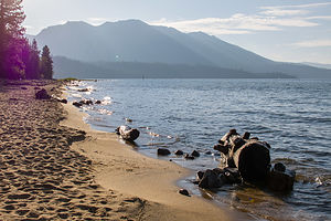
 Baldwin Beach on Lake TahoeI am not even going to attempt to give a full description of what Lake Tahoe has to offer, as we only spent a short time on its southern shore.
However, briefly, Lake Tahoe is one of the highest elevation lakes (6,255 feet high) in the U.S., as well as the second deepest (1,645 feet deep) – Crater Lake is the deepest. It is located along the border between California and Nevada. The four shores of the lake are each quite different. The north is quiet and upscale, the west and east are more rugged and less developed, and the south shore is busy and tacky with neon-lit hotels and casinos. The 72-mile drive around the lake is very scenic.
Lake Tahoe is known for its clear blue and green waters and the panorama of mountains that surround it on all sides. It is a year-round destination with swimming, boating, kayaking, and various other kinds of water sports during the summer; hiking, backpacking, and camping all year round; and tremendous skiing and snowboarding in the winter.
Two interesting nearby sites we did enjoy, include:
Tallac Historic Site
The Tallac Historic Site is comprised of three private estates dating back to the early 1900s, which served as summer retreats for three very socially prominent families from the San Francisco Bay area. In an effort to preserve “Old Tahoe,” the U.S. Forest Service acquired 74 acres, which included the three estates and a quarter mile of lakefront between Emerald Bay and Camp Richardson.
Today the remains of the restored estates attract thousands of visitors interested in recapturing this bygone and significant era in Tahoe’s history. Although the architecture of each is unique from its neighbors, each captures some aspect of the “Old Tahoe” style.
A list of activities and tours is available at the Visitor Center and the Baldwin museum.
- ‹ previous
- 4 of 5
- next ›
South Lake Tahoe Area location map in "high definition"
Javascript is required to view this map.
