- Home
- About
- Map
- Trips
- Bringing Boat West
- Migration West
- Solo Motorcycle Ride
- Final Family XC Trip
- Colorado Rockies
- Graduates' XC Trip
- Yosemite & Nevada
- Colorado & Utah
- Best of Utah
- Southern Loop
- Pacific Northwest
- Northern Loop
- Los Angeles to NYC
- East Coast Trips
- Martha's Vineyard
- 1 Week in Quebec
- Southeast Coast
- NH Backpacking
- Martha's Vineyard
- Canadian Maritimes
- Ocracoke Island
- Edisto Island
- First Landing '02
- Hunting Island '02
- Stowe in Winter
- Hunting Island '01
- Lake Placid
- Chesapeake
- Provincetown
- Hunting Island '00
- Acadia in Winter
- Boston Suburbs
- Niagara Falls
- First Landing '99
- Cape Hatteras
- West Coast Trips
- Burning Man
- Utah Off-Roading
- Maui
- Mojave 4WD Course
- Colorado River Rafting
- Bishop & Death Valley
- Kauai
- Yosemite Fall
- Utah Off-Road
- Lost Coast
- Yosemite Valley
- Arizona and New Mexico
- Pescadero & Capitola
- Bishop & Death Valley
- San Diego, Anza Borrego, Joshua Tree
- Carmel
- Death Valley in Fall
- Yosemite in the Fall
- Pacific Northwest
- Utah Off-Roading
- Southern CA Deserts
- Yosemite & Covid
- Lake Powell Covid
- Eastern Sierra & Covid
- Bishop & Death Valley
- Central & SE Oregon
- Mojave Road
- Eastern Sierra
- Trinity Alps
- Tuolumne Meadows
- Lake Powell Boating
- Eastern Sierra
- Yosemite Winter
- Hawaii
- 4WD Eastern Sierra
- 4WD Death Valley +
- Southern CA Deserts
- Christmas in Tahoe
- Yosemite & Pinnacles
- Totality
- Yosemite & Sierra
- Yosemite Christmas
- Yosemite, San Diego
- Yosemite & North CA
- Seattle to Sierra
- Southwest Deserts
- Yosemite & Sierra
- Pacific Northwest
- Yosemite & South CA
- Pacific Northwest
- Northern California
- Southern Alaska
- Vancouver Island
- International Trips
- Index
- Tips
- Books
- Photos/Videos
- Search
- Contact
Kodachrome Basin State Park, UT
Wednesday, July 16, 2003 - 9:00am by Lolo
208 miles and 6 hours from our last stop - 1 night stay
Travelogue
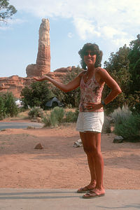
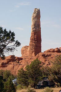
 Lolo being playful with Big StoneyIt's hard for me to think of Kodachrome State Park without getting this stupid grin on my face. The park is very beautiful and has over 60 beautiful, multicolored rock pillars called sand pipes that are found nowhere else in the world. The most prominent and by far the most interesting sandpipe is the very large, anatomically correct, phallus-shaped one that overlooks the campground. And as if that wasn't amusing enough, its name is "Big Stoney." It functioned like a magnet. No matter how hard I tried, my beach chair would always wind up being oriented right towards it. I think Herb was starting to get a bit insecure.
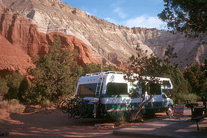
Seriously though, the park is a real gem and much less crowded than nearby Bryce. The campground is located in one of the most spectacular settings I've ever camped in--a beautiful natural amphitheater with views on all sides. There are only 27 sites, but we had no trouble getting one. I think it was because there were no hookups and most people don't like to primitive camp.
 Lolo hiking the Eagle's View TrailAfter Herb pried me away from my beach chair, we headed out on our mountain bikes to explore some of the other less graphic sandpipes. Fortunately, the Panorama Trail, which we wanted to go on, allowed mountain bikes. It was the only trail in the park that did, but at least they had one. National Parks don't allow mountain biking at all on any of their trails. The trail took us through a pretty valley with some very colorful and interesting sandpipes, such as the Ballerina Slipper spire and a series of wide-brimmed pedestals called the Hat Shop. Very nice and what was even better--we didn't see another soul the entire time.
On the way back, we stopped at the camp store for some ice cream and had to search out back for someone to wait on us. Finally, we found a nice old lady that ran the place by herself. At first, we felt bad that she might be lonely out here, but after talking to her we realized that she was quite content with her remote surroundings. The town of Cannonville was only 6 miles away so that gave her a chance to be around people whenever she chose to. She told us about a Root Beer and Fiddler Festival they were having in town that weekend and said that she hoped we would be able to stay around for it. I really wish we could have. I think it would have been fun.
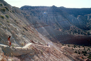
 Nice Campsite in Kodachrome BasinThe next morning while the kids slept in, Herb and I hiked the Eagle's View Trail, a trail that I had read about and very much wanted to do. The guidebook described the trail as strenuous, narrow, and exposed. They weren't kidding. As we climbed higher up the 1,000-foot, steep cliff face, the trail eventually narrowed to less than a foot wide, with a very steep drop-off. Herb kept pointing out the spectacular view in an attempt to take my mind off of the possibility of my imminent death. "Look you can see the campground and the RV," Herb said pointing at what looked like a matchbox car. Not even "Big Stoney," which from this height wasn't all that big, could cheer me up at this point. I realized that the trail really was quite visible from the campground. In fact, if the kids had woken up and looked out the window, they could have seen their mother crawling on all fours along the face of the cliff in front of the RV. Not a very pretty sight. Fortunately, they didn't.
Description

Geologists believe that these sand pipes are actually solidified sediment that filled ancient geysers and springs and was left standing after the softer sandstone surrounding it eroded away. They vary in size from 6 feet to nearly 170 feet high and their colors vary from soft whites and yellows to more dramatic pinks and reds. The most interesting rock spire of all is "Big Stoney," a phallus-shaped sand pipe overlooking the campground. After doing an article about this park in 1949, the National Geographic Society named it Kodachrome Basin because it's a photographer's paradise.
Kodachrome Basin has several short trails that lead to the most scenic view points. The Panorama Trail loops 3 miles through a valley with colorful sand pipes and interesting rock formations such as the Ballerina Slipper spire and the wide-brimmed pedestals in the Hat Shop. This is the only trail on which mountain biking is allowed. The ¾ mile Eagle's View Trail takes you 1,000 feet up steep cliffs overlooking the campground for tremendous views from the overlook. It is quite strenuous, narrow, and exposed.
The park has a 27-site campground located in a natural amphitheater right by "Big Stoney." Except for busy summer weekends, there are usually sites available.
- ‹ previous
- 7 of 21
- next ›
Kodachrome Basin State Park location map in "high definition"
Javascript is required to view this map.
