- Home
- About
- Map
- Trips
- Bringing Boat West
- Migration West
- Solo Motorcycle Ride
- Final Family XC Trip
- Colorado Rockies
- Graduates' XC Trip
- Yosemite & Nevada
- Colorado & Utah
- Best of Utah
- Southern Loop
- Pacific Northwest
- Northern Loop
- Los Angeles to NYC
- East Coast Trips
- Martha's Vineyard
- 1 Week in Quebec
- Southeast Coast
- NH Backpacking
- Martha's Vineyard
- Canadian Maritimes
- Ocracoke Island
- Edisto Island
- First Landing '02
- Hunting Island '02
- Stowe in Winter
- Hunting Island '01
- Lake Placid
- Chesapeake
- Provincetown
- Hunting Island '00
- Acadia in Winter
- Boston Suburbs
- Niagara Falls
- First Landing '99
- Cape Hatteras
- West Coast Trips
- Burning Man
- Utah Off-Roading
- Maui
- Mojave 4WD Course
- Colorado River Rafting
- Bishop & Death Valley
- Kauai
- Yosemite Fall
- Utah Off-Road
- Lost Coast
- Yosemite Valley
- Arizona and New Mexico
- Pescadero & Capitola
- Bishop & Death Valley
- San Diego, Anza Borrego, Joshua Tree
- Carmel
- Death Valley in Fall
- Yosemite in the Fall
- Pacific Northwest
- Utah Off-Roading
- Southern CA Deserts
- Yosemite & Covid
- Lake Powell Covid
- Eastern Sierra & Covid
- Bishop & Death Valley
- Central & SE Oregon
- Mojave Road
- Eastern Sierra
- Trinity Alps
- Tuolumne Meadows
- Lake Powell Boating
- Eastern Sierra
- Yosemite Winter
- Hawaii
- 4WD Eastern Sierra
- 4WD Death Valley +
- Southern CA Deserts
- Christmas in Tahoe
- Yosemite & Pinnacles
- Totality
- Yosemite & Sierra
- Yosemite Christmas
- Yosemite, San Diego
- Yosemite & North CA
- Seattle to Sierra
- Southwest Deserts
- Yosemite & Sierra
- Pacific Northwest
- Yosemite & South CA
- Pacific Northwest
- Northern California
- Southern Alaska
- Vancouver Island
- International Trips
- Index
- Tips
- Books
- Photos/Videos
- Search
- Contact
Hart Mountain Wildlife Refuge, OR
Thursday, September 12, 2019 - 3:30pm by Lolo
60 miles and 2 hours from our last stop - 1 night stay
Travelogue
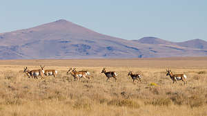 Pronghorn Antelope of Hart Mountain Wildlife RefugeIt was a lovely drive west along the gravel Rock Springs Road through sagebrush grasslands to the Hart Mountain National Antelope Refuge. It was so desolate that passing cars and trucks actually waved to each other in a sign of shared humanity.
Like Steens Mountain, Hart Mountain is also a massive fault block rising from the flats, in this case the Warner Valley. This 278,000-acre refuge was established in 1936 to protect remnant populations of pronghorn antelope.
Some fun facts about pronghorn antelopes:
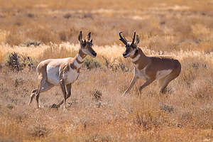 Pronghorn Antelope of Hart Mountain Wildlife Refuge
They are not antelopes, but, in fact, their closest relative is the giraffe.
They are the fastest animals in the western hemisphere - remember that when you are trying to take their photograph. They can reach speeds of up to 65 mph and run at 30 mph for many miles
They have branched horns, not antlers that are shed and re-grown each year
When they are startled, they raise the hair on their rump and the white patch can be seen for miles - we have lots of pictures of their started white rumps
Their vision is comparable to a human with a pair of wide-angle 8-power binoculars. Plus they can see 320 degrees around - so good luck sneaking up on them
They can eat plants found in the grasslands that are toxic to domestic animals
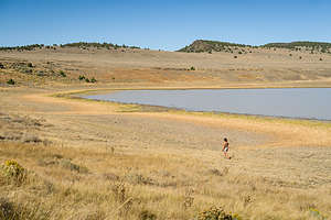 Lolo strolling along Petroglyph LakeSo, I think we can all agree that they are pretty unique and fascinating animals, as well as very beautiful ones.
We weren’t even in the Refuge yet, before we saw our first band (groups of them are called bands, not herds) of pronghorns in the grasslands along Rock Creek Road. Of course, we immediately pulled over to try to photograph them in the distance, remaining in the car so as not to scare them off. We had no idea at that point whether these would be the only ones we saw. They were pretty far away, but very aware of our presence. Usually one or two of them tried to stare us down, while the other less dominant ones displayed their white backsides to us.
They are usually more easily seen in early morning and late afternoon, so we thought it boded well for some more spottings as this was mid-day.
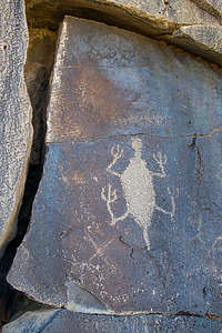 Petroglyph along Petroglyph LakeThere is only one campground in the Refuge, so we wanted to go there directly to make sure it had room for us, as there was nowhere else to stay anywhere near. Plus, we read that it has a natural hot spring, so we thought that might be a nice way to spend the afternoon before going out again to photograph pronghorns later in the day.
After taking a drive through the campground and seeing that there were plenty available sites, we drove over to the hot spring, adjacent to the campground. Unlike other natural hot springs we had been in, this one had a cinder-block enclosure surrounding it - I guess for privacy, but it also blocked the lovely views. The couple already in the pool told us that there was another natural spring just 100 yards away, without an enclosure.
We grabbed our chairs and a cooler and easily found the spring, a lovely natural pool, with a perfect temperature and nice flat rocks to sit on. It was a great way to pass the afternoon - and we had it totally to ourselves, even as we saw several people entering the other one.
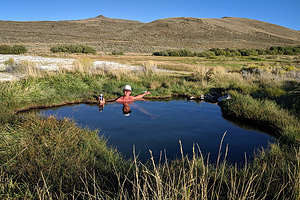 Herb enjoying the natural hot springSufficiently relaxed, we decided to head to Petroglyph Lake, which, as its name implies, has numerous petroglyphs, and is also a place where pronghorn antelope like to hang out in the afternoon.
It took us a long time to get there, because we came coming across bands of pronghorns on our drive. We stopped numerous times along the way to photograph them, but it was tough as they are extremely cautious and usually keep themselves at quite a distance. Although I tried to take pictures of them with my cell phone, they just looked like little dots surrounded by vast grasslands. Fortunately, Herb was able to quietly get out of the car and set up a tripod. That afternoon he probably took over 400 pictures, trying to get at least a few in focus.
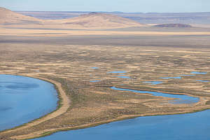 View from Warner Valley LookoutWe eventually got to Petroglyph Lake and took a walk alongside the basalt boulders and cliffs that face the lake. Starting at about 0.3 miles we started to see a few etched on the rocks - lots of turtles and lizards. The best ones were at the far end of the cliff, about 0.8 miles from the parking area. There was one that even looked like an alien, or as I pointed out Kenny from South Park.
There were no pronghorns hanging around the lake, but we did see a half dozen or so silhouetted along the ridge.
Afterwards, we took a drive out to the Warner Valley Overlook, along the western boundary of the Refuge, for a wonderful view of the interestingly textured potholes, lakes, and marshes about ¾ of a mile below us.
It had been a great day, and our concern of not seeing any pronghorn antelope was unwarranted, as over the course of the day we had probably seen over a hundred. I think if you just drive slowly and keep your eyes peeled on the grasslands, you are pretty much guaranteed to see lots of them.
Description
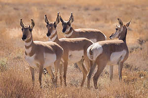 Pronghorn Antelope of Hart Mountain Wildlife RefugeThe Hart Mountain National Antelope Refuge, located near the town of Lakeville in south central Oregon, was created in 1936 as a range for remnant herds of pronghorn antelope. The range lies upon on a massive fault block ridge that rises abruptly from the Warner Valley Wetlands, ¾ of a mile below. The west face of the mountain has rugged cliffs, steep slopes, and sharp ridges, while the east side descends into rolling hills and low ridges to sagebrush grasslands.
The diversity of the terrain creates a rich mix of habitat types for over 300 species, such as pronghorn antelope, California bighorn sheep, mule deer, and sage-grouse.
The area around Petroglyph Lake and Hilltop Reservoir is a good place to look for pronghorn and bighorn sheep, especially early in the morning and very late in the afternoon.
Also at Petroglyph Lake are numerous petroglyphs on the basalt boulders and cliffs facing the lake. The best images are towards the far end of the cliff, about 0.8 miles from the parking area.
There is a very nice, free campground 4 miles to the south of the visitor center, with a great natural hot spring surrounded by a cinder-block privacy wall.
- ‹ previous
- 6 of 9
- next ›
Hart Mountain Wildlife Refuge location map in "high definition"
Javascript is required to view this map.
