- Home
- About
- Map
- Trips
- Bringing Boat West
- Migration West
- Solo Motorcycle Ride
- Final Family XC Trip
- Colorado Rockies
- Graduates' XC Trip
- Yosemite & Nevada
- Colorado & Utah
- Best of Utah
- Southern Loop
- Pacific Northwest
- Northern Loop
- Los Angeles to NYC
- East Coast Trips
- Martha's Vineyard
- 1 Week in Quebec
- Southeast Coast
- NH Backpacking
- Martha's Vineyard
- Canadian Maritimes
- Ocracoke Island
- Edisto Island
- First Landing '02
- Hunting Island '02
- Stowe in Winter
- Hunting Island '01
- Lake Placid
- Chesapeake
- Provincetown
- Hunting Island '00
- Acadia in Winter
- Boston Suburbs
- Niagara Falls
- First Landing '99
- Cape Hatteras
- West Coast Trips
- Burning Man
- Utah Off-Roading
- Maui
- Mojave 4WD Course
- Colorado River Rafting
- Bishop & Death Valley
- Kauai
- Yosemite Fall
- Utah Off-Road
- Lost Coast
- Yosemite Valley
- Arizona and New Mexico
- Pescadero & Capitola
- Bishop & Death Valley
- San Diego, Anza Borrego, Joshua Tree
- Carmel
- Death Valley in Fall
- Yosemite in the Fall
- Pacific Northwest
- Utah Off-Roading
- Southern CA Deserts
- Yosemite & Covid
- Lake Powell Covid
- Eastern Sierra & Covid
- Bishop & Death Valley
- Central & SE Oregon
- Mojave Road
- Eastern Sierra
- Trinity Alps
- Tuolumne Meadows
- Lake Powell Boating
- Eastern Sierra
- Yosemite Winter
- Hawaii
- 4WD Eastern Sierra
- 4WD Death Valley +
- Southern CA Deserts
- Christmas in Tahoe
- Yosemite & Pinnacles
- Totality
- Yosemite & Sierra
- Yosemite Christmas
- Yosemite, San Diego
- Yosemite & North CA
- Seattle to Sierra
- Southwest Deserts
- Yosemite & Sierra
- Pacific Northwest
- Yosemite & South CA
- Pacific Northwest
- Northern California
- Southern Alaska
- Vancouver Island
- International Trips
- Index
- Tips
- Books
- Photos/Videos
- Search
- Contact
Yosemite Valley, CA
Thursday, October 13, 2022 - 2:45pm by Lolo
256 miles and 5.5 hours from our last stop - 8 night stay
Travelogue
Day 1 - Arrival and stroll to Mirror Lake
_0.thumbnail.jpg) Trail to Mirror LakeWhenever we arrive in Yosemite, which is usually in the late afternoon after 5 ½ hours of driving, I feel compelled to practically jump out of the motorhome to immerse myself in its meadows and trees before our engine has even had time to cool down.
Trail to Mirror LakeWhenever we arrive in Yosemite, which is usually in the late afternoon after 5 ½ hours of driving, I feel compelled to practically jump out of the motorhome to immerse myself in its meadows and trees before our engine has even had time to cool down.
We have been here so many times that It feels like coming home.
Herb, on the other hand, has a different approach to celebrating our arrival, which involves sipping a gin and tonic while gazing out the large back windows of the motorhome at the granite cliffs. After all, he did drive the entire 5.5 hours here.
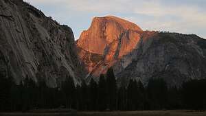
There wasn’t much daylight left, so I just took a quick walk from the campground and walked one mile on the Mirror Lake trail before turning back. I didn’t make it to the lake (which had no water in it anyway), but I did get to say hello to Half Dome, which as all aglow in the golden hour.
Day 2 - Valley Loop Bike Ride
.thumbnail.jpg) Valley Loop Bike RideEarly the next morning we drove the motorhome over to the Church Bowl picnic area because it was one of the few spots in the Valley that gets early morning sun.
Valley Loop Bike RideEarly the next morning we drove the motorhome over to the Church Bowl picnic area because it was one of the few spots in the Valley that gets early morning sun.
We weren’t the only ones with this idea, so we pretty much had to get there by 8:30 to nail a parking space. Most of the other occupants of the spot were twenty- or thirty-something climbers in white vans (like both of our sons) prepping for a big wall climb the following day. In fact, one out of five vehicles in the Valley were white Promaster vans.
.thumbnail.jpg) Herb and El CapI was excited at the prospect of seeing their two vans in the campsite across from us tomorrow morning. I hope they both would fit.
Herb and El CapI was excited at the prospect of seeing their two vans in the campsite across from us tomorrow morning. I hope they both would fit.
From there, we set out on our bikes for a ride along the Valley Loop trail. We stopped first in Yosemite Village to visit the Ansel Adams Gallery and to walk through the old Yosemite Cemetery, where many of the men and women important to the early history of Yosemite are buried, like Galen Clark, its first caretaker and George Anderson, the first person to ascent to the summit of Half Dome.
Every Halloweeen, the Yosemite Conservancy offers a spooky tour through the cemetery at night to visit the graves of these people and meet their ghosts.
.thumbnail.jpg) El Cap ReflectionsWhen it was time to hop back on our bikes, we discovered that I had a flat tire. Thank God that Herb is handy, so we were soon back on the bike bath again.
El Cap ReflectionsWhen it was time to hop back on our bikes, we discovered that I had a flat tire. Thank God that Herb is handy, so we were soon back on the bike bath again.
From there we continued on the north side of the Valley Loop trail to the El Cap Crossover road which brought us over to Southside Drive.
We stopped at Cathedral Beach, one of our favorites, where there are wonderful reflections of towering El Cap in the Merced River.
Then we continued back along the South Side Drive adding the Happy Isle Loop road on so that I could get our mileage up to a more respectable 15-mile bike ride.
Bikes are definitely my favorite way to get around the Valley.
Day 3 - Boys and wives arrive, bouldering, and Church Bowl sunset
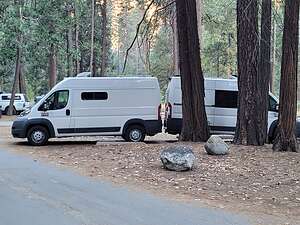 The boys have arrived!I woke up the next morning and immediately peeked out the window to see if the kids had safely arrived. Sure enough, there were two white Promaster Vans across from us, squeezed so tightly into the campsite that the back bumpers of each were practically touching each other.
Eventually they wandered off to have bagels and coffee with us. Funny, how they just assume mom is going to have food to feed them.
The boys and their wives are very avid and accomplished rock climbers, so when they do get a chance to visit the Valley, that is pretty much what they do.
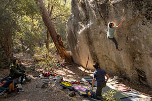 The Thriller Boulder in Camp 4So the plan was to do some bouldering in the morning, followed by bouldering in the afternoon.
We spent the morning in Camp 4, the famous rock climbers’ campground located near the base of Yosemite Falls. Some of the world’s most renowned climbers have used it as their base when climbing in Yosemite.
So important was this site to the climbing community, that when its removal was threatened in the late 1990s, a campaign was started to save it.
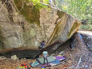 Diesel Power Boulder in Camp 4It worked, and today it is listed on the National Register of Historic Places for "its significant association with the growth and development of rock climbing in the Yosemite Valley during the 'golden years' of pioneer mountaineering.”
So here we were, on hallowed climbing ground. Even if you don’t climb, it’s fun to just walk through this camp and watch the bouldering that goes on here.
Herb and I also like to climb, but only sport climbing, not bouldering. So today we would just spectate.
Bouldering is quite different from trad and sport climbing, which is done with ropes and gear on a rock wall. Instead, it is done on freestanding boulders, where the routes are generally short.
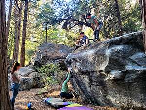 Ahwahnee BouldersTo help cushion the inevitable fall, crash pads are placed on the ground and other climbers (and, in our case, sometimes even climbers’ mothers) spot the person bouldering by standing below with arms outstretched, ready to protect the climber’s head from hitting any rocks off the pad.
Also, bouldering has its own difficulty grading system. Rather than the 5.0 – 5.14 grades used for trad and sport climbing, boulder routes are graded from V0 to V14.
Boulder routes are referred to as boulder problems, because figuring them out and completing them is very much like solving a problem – finding just the right moves and holds and putting the sequence together.
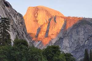 Half Dome in Golden HourMany climbers will work on a difficult boulder problem for weeks or even years. It is often quite elegant and beautiful to watch, and a cause for celebration when achieved.
The boys had scouted out ahead of time a few boulder problems that they wanted to work on.
The first was a V9 called Thriller and the second was a V10 called Diesel Power. They both looked ridiculously hard.
In the afternoon, we moved our operation to Church Bowl, where the kids played around on a few of the Ahwahnee boulders before getting down to the business of cocktail hour and watching the sun set over Half Dome.
Day 4 - Hike to Glacier Point from Valley
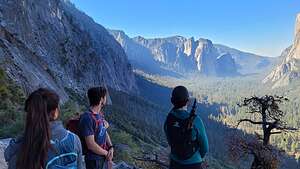 Along Four Mile TrailEvery year all I ask for Christmas is that I can get a photo of the six of us together to send out on our family Christmas cards, and every year it’s the same griping and complaining about stopping whatever we are doing to pose.
It’s a rare event that I can get all six of us together in a spot worthy of a Christmas card, so I wasn’t above guilting them into it.
What I had in mind was a big family hike up Four Mile Trail from the Valley Floor to Glacier Point. It’s a big effort - over 11 miles with a 3,500 elevation gain.
One problem - Celeste, who would normally not have found this hard at all, had an ankle issue and wasn’t sure whether she would be able to go the whole distance.
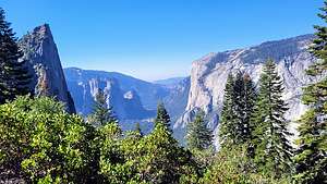 Along Four Mile TrailAfter much debate, we decided to give it a try and just turn around if necessary.
There’s not much parking along Southside Drive for the Four Mile Trail, so we decided to park in Visitor Parking near the Yosemite Lodge on Northside Drive and hike across the meadow and over Swinging Bridge to get to the Four Mile Trailhead. This would add a half mile each way to an already very long hike.
Plus, the kids were leaving this afternoon after we got back from the hike, so they would be better positioned to make a quick exit without the normal Sunday traffic backlog, if they were positioned on Northside Road.
We set off on the inaccurately named Four Mile Trail (it’s actually 4.8 miles) and after a brief flat area wandering through some boulders, we began to climb. In fact, from that point on, all we did was climb, as we had a lot of vertical feet to gain.
.thumbnail.jpg) Christmas Card - Take OneThe scenery started slowly, since we had to get above the Valley trees first, but once we did, all the icons of the Valley came into view - Yosemite Falls, Cathedral Rocks, El Cap, Half Dome, Clouds Rest, North Dome, and more. It was like a tour of Yosemite’s greatest hits.
Christmas Card - Take OneThe scenery started slowly, since we had to get above the Valley trees first, but once we did, all the icons of the Valley came into view - Yosemite Falls, Cathedral Rocks, El Cap, Half Dome, Clouds Rest, North Dome, and more. It was like a tour of Yosemite’s greatest hits.
We stopped to take a family photo here, just in case Celeste’s ankle would prevent us from making it all the way. But she was a real trooper and said we should continue on.
It wasn’t a bad photo, and probably would have been good enough for a Christmas card, but we forged on.
The tremendous views were a great distraction from the fact that we were climbing and climbing along a continuous series of switchbacks.
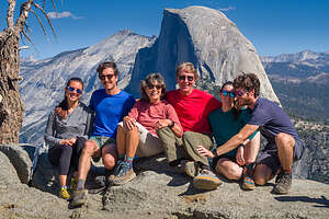 Maybe not this oneAt one point, Celeste and Andrew fell behind a bit and I saw them in deep discussion. Uh uh. Maybe Celeste’s ankle was bothering her too much to go on, but then they started moving again up towards us.
As we came around to the northeast side of the valley wall, Half Dome came into view. The switchbacks were now done and the trail became less steep. One more mile to go.
Once we came off the Four Mile Trail, we continued left down a paved trail to what is one of the best views in Yosemite, where we found the usual crowd of people, most of which took the easy way up by shuttle bus.
.thumbnail.jpg) Gaidus Family Christmas CardHerb set up his tripod and we assumed our positions, with Half Dome as a backdrop.
Gaidus Family Christmas CardHerb set up his tripod and we assumed our positions, with Half Dome as a backdrop.
I thanked them all for humoring me, especially Celeste, but it turned out to be a really good photo - probably our best Christmas card to date.
The way down is always harder than up, especially on the knees.
Although we were retracing our steps on the way down, the views were completely different in this direction - Half Dome, Yosemite Falls, those miles of switchbacks, and finally to my favorite view of all looking out over El Capitan and the western Yosemite Valley during Golden Hour.
Back at the cars, we hugged and said our goodbyes. They had added so much fun and laughter to our trip. I missed them before they even got out of the park.
Day 5 - Sentinel Beach, Valley Loop Bike Ride, Sunset in Meadow
 Herb on the quiet Sentinel BeachAfter our busy weekend with the kids, today was more of a chill day, hanging out on a beach, taking a bike ride, enjoying sunset from a meadow - you know, old folks stuff.
Today we wanted to cover the western portion of the Valley Loop trail, so we parked along the Northside Drive where a bend in the Merced River came close to the road.
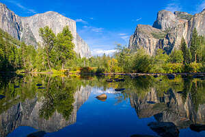 Valley ViewFrom there we walked down to Sentinel Beach, or more correctly the little beach on the other side of the Merced from Sentinel Beach. Not many people come here as opposed to the larger beach on the other side of the river, so it was much more quiet and peaceful. We spent most of the morning reading and taking photos.
Later that afternoon, we took our bikes off the back of the Subaru and headed along the Valley Floor trail towards Valley View. This section of the Valley Loop Trail is a bit dicier so there were times we chose to ride out on the road rather than deal with rocks and fallen trees.
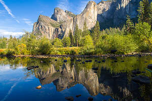 Valley ViewOur next stop along the loop road was the very popular Valley View near the end of the Northside Drive, where El Capitan, on the left, and Cathedral Rocks, on the right, frame a magnificent valley view.
.thumbnail.jpg) Two Golden Half DomesIt’s an iconic shot, so the challenge is to make your photograph different than the one everyone else takes. Normally, there is a tour bus with dozens of people vying for the same shot. Today we were fortunate enough to have it to ourselves.
Two Golden Half DomesIt’s an iconic shot, so the challenge is to make your photograph different than the one everyone else takes. Normally, there is a tour bus with dozens of people vying for the same shot. Today we were fortunate enough to have it to ourselves.
From Valley View, we took the left back around onto Southside Drive and rode for a few miles before turning left onto the El Cap Crossover road to get back to Northside Drive along which our Subaru was parked.
It was a very nice ride and just under 9 miles. As I said many times, bikes are the best way to get around the Valley.
We spent that evening wandering around Cook’s Meadow, between Sentinel Bridge and Swinging Bridge, during the golden hour. Sometimes, but now always, Sentinel Rock and Half Dome take on a golden hue. Tonight we were lucky. We were even able to get two Half Domes thanks to the Merced River.
Later that evening we went over to Ahwahnee Grand Lounge with our kindles and a bottle of wine.
Day 6 - North Dome Hike
.thumbnail.JPG)
There are four classic hikes above Yosemite Valley that provide expansive views of the Valley and the surrounding cliffs: Four Mile Trail to Glacier Point, which we had done earlier this week; the Half Dome Cable route, which we have done twice; the precarious Cloud Rest hike, which I had been afraid to do for years but lived through it, and today’s planned hike to North Dome, which we had done with the boys about 8 years ago. It was well overdue for a return visit.
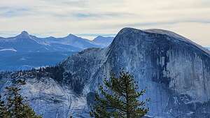 Half Dome and Clouds Rest in distanceThe drive to the trailhead at Porcupine Creek was about 43 miles from our campground. This is usually a very popular hike, but today the parking lot was empty, so it was a good chance that we would have this hike to ourselves.
Unlike the other hikes we had done this week, the trail started down rather than up, which it continued to do for about a mile through a lovely, quiet pine forest. There was no one else around, so it was very, very peaceful.
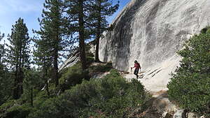
The last time we hiked this back in 2014, on the way back from North Dome, Herb and Andrew actually took the Tenaya Canyon hike back down to the Valley while Tommy and I went back to the trailhead and drove the car back.
This time we continued straight towards North Dome.
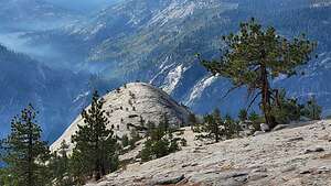 Down to the North Dome SummitAt 2.5 miles we came to another junction for the side trip to Indian Rock. We had done that last time, so we decided to skip that this time and continue on.
As the trail made its way up the ridge, we came to a big flat granite area that I at first thought was North Dome, but realized we hadn’t gone far enough yet. I knew that because whenever we hike I clutch a GPS that tells me how far we’ve gone, what our elevation is, etc. I use it for reinforcement that I am actually making progress. This false North Dome was just a treeless portion of Indian Ridge.
.thumbnail.jpg) Our granite reclinerNow that we were out of the trees, the views were getting really good, and as we continued on, they just kept getting better and better. Eventually, we saw the real North Dome, a huge smooth granite plateau jutting out before us.
Our granite reclinerNow that we were out of the trees, the views were getting really good, and as we continued on, they just kept getting better and better. Eventually, we saw the real North Dome, a huge smooth granite plateau jutting out before us.
At 4.5 miles, we took the left spur for the hike down (that’s right, down) to the summit of North Dome. This is probably the first summit that I have ever descended to, but that’s because Tioga Road is so high.
As we made our way down to the summit, it seemed like the whole world lay before us – Clouds Rest and Tenaya Canyon to the northeast, Yosemite Valley below, and our old favorite Half Dome just across the canyon.
We spent most of our time on the summit trying to take a picture of the two of us sitting on a rock that looked a bit like a lady’s shoe, heel and all, with the wider version of Half Dome as a dramatic backdrop. We looked like Etruscans reclining on a couch.
Finally, we pried ourselves off our stone couch and began our ascent off the summit of the Dome, back across the other false granite dome, through the peaceful forest, and then back up to the car.
10.3 fabulously scenic miles, with a 1,924-foot elevation gain (mostly on the way back).
We got back to the Valley just in time to see a glorious sunset.
Day 7 - Mariposal Grove
.thumbnail.jpg) The Grizzly GiantFor a very different perspective of Yosemite, we left the giant granite cliffs of the Valley behind today and drove 30 twisty miles south to Wawona and the Mariposa Grove to see the giant Sequoias.
The Grizzly GiantFor a very different perspective of Yosemite, we left the giant granite cliffs of the Valley behind today and drove 30 twisty miles south to Wawona and the Mariposa Grove to see the giant Sequoias.
It seems like everything about this Park is super-sized.
There are actually three sequoia groves in Yosemite, but by far the largest and most impressive is the Mariposa Grove where there are about 500 giant sequoias, many of which are more than 3,000 years old. They are considered to be the largest living things on earth – almost 300 feet tall, 50 feet in circumference, and about 2 million pounds.
It is one of the most highly-visited attractions in all of Yosemite.
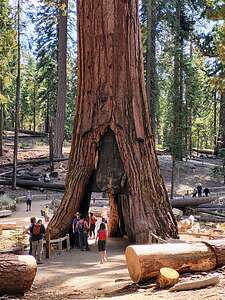 The California Tunnel TreeIn 2015, the Grove underwent a massive 3-year restoration project, removing parking lots and roads, in an attempt to improve the habitat for the sequoias. They also eliminated the open-air trams that used to take visitors on a tour through the Upper Grove. Now you have to hike to it.
The last time we were here, we were able to drive in and park near the groves, but now visitors have to park at the Mariposa Grove Welcome Center and take the free shuttle bus to the Lower Grove. It runs approximately every 15 minutes.
However, we didn’t want to wait and get on a crowded shuttle bus, so we walked from the Welcome Center to the Lower Grove, adding about 0.6 miles (each way) onto our hike for the day.
There was a large crowd disembarking from a shuttle bus when we got there, and they were all headed the same direction - to the right to see the Grizzly Giant, by far the most spectacular tree in the Grove, and only 0.7 miles from the trailhead.
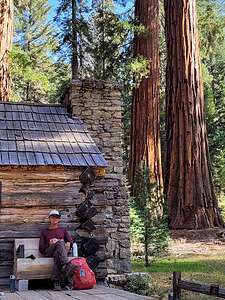 Mariposa Grove CabinWe hurried onto the trail so we could get there before the crowd.
Rising 209 feet in the air with a circumference of 96.5-foot, and weighing in at roughly 2 million pounds, it is the 2nd largest tree in Mariposa Grove and the 26th largest tree in the world. it is quite impressive.
It’s also the oldest tree in Mariposa Grove, with the best estimate of its age being 2,995 years old (plus or minus 250 years).
It was scary to think that just 3 months ago, the Washburn Fire threatened Grizzly Giant and other trees in Mariposa Grove, but firefighters saved the day by installing a ground-based sprinkler system in the grove to increase the humidity near the trees.
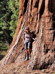 These trees are hugeAfter paying homage to the Grizzly Giant, we came to the California Tunnel Tree, which was cut in 1895 to allow horse-drawn stagecoaches to pass through.
Fun fact: There were once two trees in this grove that were tunneled to allow coaches through, but unfortunately the other one is now called the Fallen Wawona Tunnel Tree, because it fell during a winter storm in 1969, when it was just 2,100 years old. We would see that later on our hike.
So now, this one is now called the Surviving Tunnel Tree because it is not only standing, but still alive.
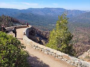 Wawona PointMost visitors turn left here to continue on the relatively easy 2-mile Grizzly Giant Loop through the Lower Grove, since the trail to the Upper Grove is fairly strenuous and steep.
As we continued on the Perimeter Trail to the Upper Grove, it became quieter and less touristy, and yes, much steeper. The trail narrowed and there were no more wooden railings separating us from the trees. It felt like we were experiencing this grove like the pioneers and early adventurous tourists were.
At about two miles into our hike, we took the left branch of the guardian loop, which soon brought us to a beautiful log cabin with benches on the front porch.
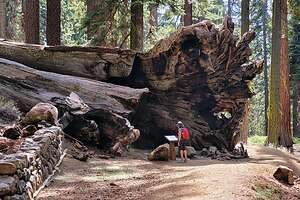 The Fallen MonarchGalen Clark built this cabin in 1858, a year after his discovery of the grove. Clark later on went on to become the first “Guardian” of Yosemite after the Yosemite Grant was signed by President Lincoln in 1864. It was Clark that persuaded Congress to protect the Mariposa Grove of Giant Sequoias as well as Yosemite Valley for future generations.
The cabin later served as the Mariposa Grove Museum up until the 2015 restoration project to remove all development in the grove. The cabin was boarded up and contents were moved to the bus stop near the parking area for the South Park entrance.
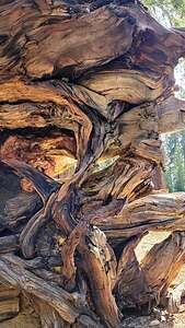 Closeup of the Fallen MonarchToo bad, because I really would have liked to peek inside there.
Galen chose his location well. There was a pretty little meadow in front of the cabin surrounded by an amphitheater of immense sequoia trees.
The benches on the front porch were the perfect place for our picnic lunch - so quiet and serene.
We continued hiking up the Guardian Loop before taking the one-mile (RT) side trip to Wawona Point, where there was a sweeping view of the pine-covered Wawona Valley and meadow.
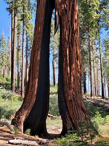 The Clothespin TreeThis Valley was once a solid green carpet of pine trees, but now there were large brown patches of dead trees caused by a bark beetle infestation brought on by years of drought that killed about a third of the trees.
Those dead pine trees helped fuel the Washburn Fire of 2022 that came dangerously close to destroying the grove.
From Wawona Point we continued back to complete the Guardians Loop. This peaceful dirt trail used to be part of the paved loop road that the open-air tram took tourists on. I think it is much better this way with the only sounds being birds rather than a tour guide with a megaphone.
We soon came to the Fallen Wawona Tunnel Tree (also called the Fallen Monarch, which, as I mentioned earlier, fell during a winter storm in 1969. I was totally dwarfed by its root system, which on its side was as tall as a three-story building. The wood was beautiful.
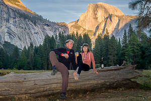 Back in the Valley in time for sunsetThis was once the most photographed tree in the grove. It was tunneled in 1881 in order to bring tourists to the grove. For over 75 years, thousands of visitors on foot, horse-drawn stage, and eventually automobiles passed through the tree’s core. Weakened by the tunnel, in 1969 it fell under the weight of a heavy winter snow load.
Eventually we worked our way back to the main Mariposa Grove Trail passing some more interesting named Sequoias along the way, like the Clothespin Tree with its distinctive split base and the Faithful Couple,two Giant Sequoia trees growing so close that they merged over the years to form a single massive trunk.
Then it was back onto the Grizzly Giant Loop trail (the part we didn’t do yet) where we joined the crowds.
I am so glad we made the extra effort to explore the Upper Grove where we could experience this beautiful place more like the way Galen Clark did and were still make it back to the Valley in time to toast the sunset.
Day 8 - Cook’s Meadow and the Ahwahnee Patio
After two big days of hiking to North Dome and then the Mariposa Grove, we were ready for a slower-paced chill day in the Valley. Plus it was our last day.
In the morning, as we do most mornings while camping in the Valley, we moved the motorhome out of the campground, which because of the high surrounding cliffs, doesn’t see sun until almost 10:00, and moved it to Southside Drive, near the Yosemite Chapel.
We would use that as a base camp for strolls and other explorations for the day.
In the morning, we strolled through Cook’s Meadow between Sentinel and Swinging Bridge, where there were lovely reflections in the river of the surrounding granite cliffs.
Then we spent the afternoon in our beach chairs, just relaxing and enjoying the river flow by.
After putting the motorhome back in its campsite, we drove the Subaru over to the Church Bowl Picnic Area, where I loaded up my backpack with a bottle of wine and some cheese and crackers, and we strolled over to the Ahwahnee Hotel.
We were fortunate to find an empty table on the outdoor patio along the lawn in the back of the Hotel.
That evening we brought some wine and cheese over to the Ahwahnee and sat at one of the outside tables on the patio. The tall pine trees blocked our view of Half Dome, so when it came time for sunset, we walked back to the Ahwahnee Meadow where there is an unobstructed view,
Half Dome did not disappoint.
- 1 of 1
