- Home
- About
- Map
- Trips
- Bringing Boat West
- Migration West
- Solo Motorcycle Ride
- Final Family XC Trip
- Colorado Rockies
- Graduates' XC Trip
- Yosemite & Nevada
- Colorado & Utah
- Best of Utah
- Southern Loop
- Pacific Northwest
- Northern Loop
- Los Angeles to NYC
- East Coast Trips
- Martha's Vineyard
- 1 Week in Quebec
- Southeast Coast
- NH Backpacking
- Martha's Vineyard
- Canadian Maritimes
- Ocracoke Island
- Edisto Island
- First Landing '02
- Hunting Island '02
- Stowe in Winter
- Hunting Island '01
- Lake Placid
- Chesapeake
- Provincetown
- Hunting Island '00
- Acadia in Winter
- Boston Suburbs
- Niagara Falls
- First Landing '99
- Cape Hatteras
- West Coast Trips
- Burning Man
- Utah Off-Roading
- Maui
- Mojave 4WD Course
- Colorado River Rafting
- Bishop & Death Valley
- Kauai
- Yosemite Fall
- Utah Off-Road
- Lost Coast
- Yosemite Valley
- Arizona and New Mexico
- Pescadero & Capitola
- Bishop & Death Valley
- San Diego, Anza Borrego, Joshua Tree
- Carmel
- Death Valley in Fall
- Yosemite in the Fall
- Pacific Northwest
- Utah Off-Roading
- Southern CA Deserts
- Yosemite & Covid
- Lake Powell Covid
- Eastern Sierra & Covid
- Bishop & Death Valley
- Central & SE Oregon
- Mojave Road
- Eastern Sierra
- Trinity Alps
- Tuolumne Meadows
- Lake Powell Boating
- Eastern Sierra
- Yosemite Winter
- Hawaii
- 4WD Eastern Sierra
- 4WD Death Valley +
- Southern CA Deserts
- Christmas in Tahoe
- Yosemite & Pinnacles
- Totality
- Yosemite & Sierra
- Yosemite Christmas
- Yosemite, San Diego
- Yosemite & North CA
- Seattle to Sierra
- Southwest Deserts
- Yosemite & Sierra
- Pacific Northwest
- Yosemite & South CA
- Pacific Northwest
- Northern California
- Southern Alaska
- Vancouver Island
- International Trips
- Index
- Tips
- Books
- Photos/Videos
- Search
- Contact
Snæfellsnes Peninsula - Arnastapi, Iceland
Saturday, June 10, 2023 - 5:45pm by Lolo
10 miles and 0.25 hours from our last stop - 1 night stay
Travelogue
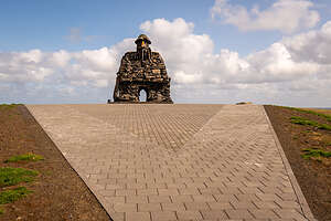 BárðurAfter leaving Djúpalónssandur, we continued along Útnesvegur (the road around the western half of the Snæfellsnes peninsula) just a few miles to Arnarstapi, a village on the southern side of the peninsula, with access to a beautiful coastal walk to the tiny village of Hellnar.
We checked into the Arnarstapi Campground, which is located close to the start of the coastal walk. The village is so small that it is pretty much close to everything. I couldn’t find the campground office at first, so I went into a pizza place to ask, only to find out that this also served as the campground office.
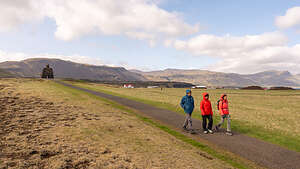 Off to Hellnar we goRight next to the campground was the Jules Verne Monument. I didn’t realize that “Journey to the Center of the Earth” took place on the Snæfellsnes Peninsula, and Arnastapi played an important role. It was the last stop on the route Professor Otto Lidenbrock and his crew took before they climbed Snæfellsjökull and entered the interior of the planet through a tunnel in the crater.
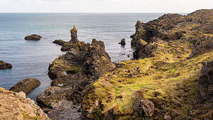 Along the Arnastapi to Hellnar hikeThe plaque reads, ‘Here begins The Voyage to the Centre of the Earth, which lies 6,371 kilometres below.”
Iceland’s dramatic scenery certainly does make one believe that fantastical things can happen here.
Speaking of fantastical things, when I asked the campground/pizza host how to get to the trail to Hellnar, she pointed out the window and said, “Head to the big troll, and turn right.” Where else but in Iceland would directions include a troll as a landmark.
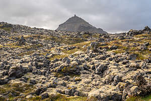 Hellnahraun lava field with Mt. Stapafell in backgroundSo we set off for the large stone Troll, whose name is Bárður. Bárður is not just any old troll but rather he is an important figure in the Icelandic Sagas and the guardian spirit of the Snæfellsnes peninsula.
Made out of stone sourced locally, it was designed and created by a sculptor called Ragnar Kjartansson to represent the story that has captured the minds of locals and tourists alike for hundreds of years.
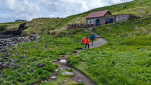 Approaching the Fjöruhúsið CaféAccording to the ancient sagas, Bárður was the first settler of this area of Iceland (back in the 9th century) and gave the peninsula its name Snæfellsnes, which in Icelandic directly translates to Snow Mountain Peninsula.
Oh, and he was half man and half troll.
When he decided that he could no longer live with humans, he went up into the mountain to live in the Snæfellsjökull glacier, where he still roams to this very day. Bárður is still very important to Icelandic culture, and has become a nature spirit that local people often ask for help in matters large and small.
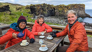 Fjöruhúsið CaféHmm…I wonder if Professor Otto Lidenbrock ever ran into Bárður before his descent into the volcano on this way to the center of the Earth. We have been so immersed in this way of thinking, that I would believe anything at this point
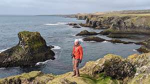
Anyway, on to Hellnar. After saying hello to Bárður, we turned right along the coastal trail towards Hellnar. The scenery along the way was breathtaking - with lots of unique, moss-covered rock formations and sea stacks along the coast.
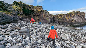 Beach below the Fjöruhúsið CaféAs we continued towards Hellnar, the terrain became rockier and more volcanic as we crossed the Hellnahraun lava field, where there were volcanic rocks of all sizes covered in a vibrant green moss.
Meanwhile on the right, pyramid-shaped Mount Stapafell, rose 1,700 feet above us, seemingly rising out of the lava field.
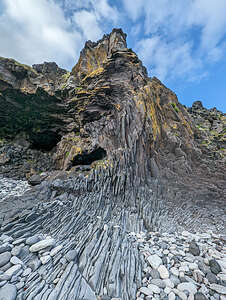 Valasnös basalt cliffBesides the incredible scenery, another reason to hike to Hellnar is the Fjöruhúsið Café of Hellnar, a picturesque Cafe on the Hellnar harbor, surrounded by rocks and bird cliffs. I had been dreaming of having coffee at this cafe even before we left for the trip. That’s why I was devastated when I saw on Google that the cafe closed at 5:00 and it was already 5:30.
But what should we see as we approached the tiny Fjöruhúsið Café, but a group of people still sitting on the outdoor deck. So we hadn’t missed out after all. I have a feeling that the closing hours are quite flexible, and that it stays open as long as there are still customers.
 Running out of suppliesSo we did get to have a cup of coffee there after all, in lovely old-fashioned porcelain cups, overlooking the water and rocky cliffs. Why is it that how good a coffee tastes is highly correlated to the beauty of the surrounding scenery? So, in this case, it was a 10.
After our coffee break, we explored the beach area below the cafe, in an attempt to find Baðstofa, a sea cave in the center of Valasnös (a basalt cliff face), famous for displaying changing colors as the sun and sea reflect off its walls. Unfortunately, we weren’t there at the right time of day for that, but still the basalt cliff and surrounding beach were quite interesting.
 Morning walk to Arnarstapi HarboThe beach was composed of a mix of black and white polished rocks, formed from different periods of the same volcanic eruptions. Apparently, it’s pretty rare to see them together like this on a beach. They were a bit tricky to walk over.
If ever there was a place that looked like a troll’s home, Valasnös was it.
From there, we turned around and walked back from whence we came - across the lava field, along the beautiful coastline, past Bárður, and back to the campground.
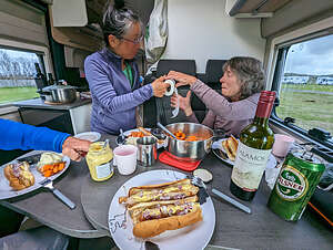
 Gatklettur - Arch RockThat night we had dinner in the van again - Herb’s pylsurs, Idahoan powdered potatoes, and carrots.
I could tell we were nearing the end of our trip, as we ran out of supplies (such as paper towels) and improvised with what we had (6 rolls of toilet paper). I think this is how anarchy begins. We still did have a nice bottle of Cab left, so it wasn’t a total loss of civilization.
The next morning before leaving Arnarstapi, the plan was to walk the coastal trail in the other direction, towards the Arnarstapi Harbor.
 Eystrigjá, the famous natural stone bridgeHerb was awake before the rest of us, so he took his camera and went on a stroll down to the coast. He wasn’t gone long before he returned somewhat flustered and said that he had been attacked by some very aggressive birds. Attacked might have been a bit of a hyperbole, as when further questioned it turned out to be more of a warning divebomb.
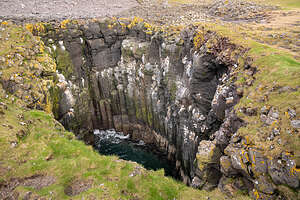 The grotto below the Stone BridgeAfter I stopped laughing, I told him that I thought that I read somewhere about aggressive birds in Arnarstapi. I googled it and sure enough there was an entire article about Arctic Terns dive bombing and pooping on people. At least he hadn’t been shat upon I told him. He was not amused.
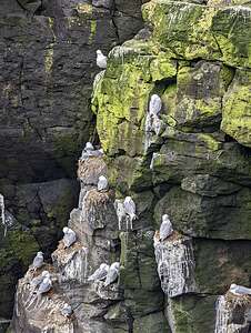 Arctic Terns in GrottoI have to admit though that I was a bit frightened about going out there. Fortunately, they were gone by the time we left on our hike.
This time, when we got to the Troll, we turned left (north) along the coastal trail.
This way was equally beautiful as our walk yesterday in the other direction. All along the coast there were small rocky islands and reefs called “skerries,” after the Old Norse word “sker.” They are also known as sea stacks and are usually found in clusters.
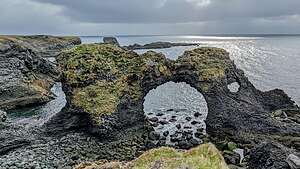
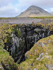 Herb's vantage point from the other side of the grottoWe soon came to a rock named Gatklettur, famous for its natural rock arch formation. The circular arch was formed by centuries of waves eroding away at it, causing beautiful swirl patterns. This is probably the most iconic and photographed rock formation in Arnarstapi.
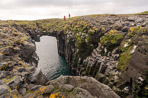
As I continued on merrily walking along a grassy path in search of Eystrigjá, the famous natural stone bridge that you can walk across, Herb yelled to me to be careful because I was about to walk out on it. What???
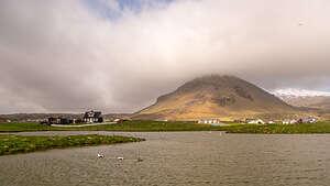 Amtmannshúsið black house across the pondOh wow!
The natural bridges and arches I knew, protruded above the ground, but this one's top was at ground level and the narrow grassy path I was about to continue on had a big dropoff on one side to a water-filled grotto about 40 feet deep
Herb was all the way on the other side of the grotto when he saw me and Hilda unknowingly stepping out on the bridge.
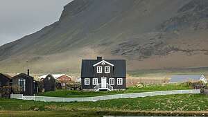 Amtmannshúsið houseThe vertical walls of the grotto below us were adorned with hexagonal basalt columns, many of which had arctic tern (or seagull?) nests atop them. There was lots of bird activity going on below.
On top of each of the column, a pair of Arctic Terns build a nest. One parent remains with the chick, while the other flies out to sea, hunting to provide precious calories for their newly hatched chicks.
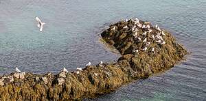 Arctic Tern colonyThese harmless looking birds, which actually look very much like regular seagulls, are quite amazing. Every year they migrate from the Arctic to Antarctica and back, traveling 44,300 miles. No other known animal on the planet has a regular migration route that comes even close to being as long.
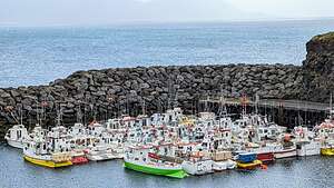 Arnastarpi Natural HarborEach year, these birds, who generally mate for life, return to the same mating grounds. That is the only time they come in contact with humans - hence the aggressive dive bombing and pooping Herb had experienced this morning. They were just being good parents protecting their young. I would do the same.
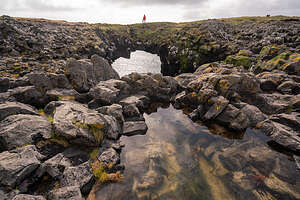 Refinding the Stone BridgeWe came to a pond, across which sat a picturesque dark wooden house called Amtmannshúsið, with pyramid-shaped Stapafell rising above it. Everything in Iceland seems to be given a name - houses, rocks, trolls, etc. - not of which are pronounceable.
This house was built in the 1770’s when Iceland was under the control of Denmark, and served as the official residence of the Danish regional governor. Iceland did not win its independence from Denmark until 1944.
As we approached the Arnarstapi Harbor, we looked down from a bluff at a rocky promontory covered with arctic terns. Thousands of them nest in Arnarstapi every summer after their long migration.
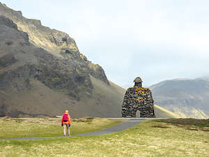 Goodbye BárðurFishing and trade are still important to the economy of Arnarstapi, but they now play second fiddle to tourism, as Iceland has definitely been discovered by travelers from around the world.
On our way back to the campground, we tried to find the Stone Bridge again, but it wasn't so easy. Perhaps, if it was more accurately called the "grassy path across a hidden grotto" it would have been more obvious. Finally, we figured if we went back to the spot where Herb took the photo of me about to step on the bridge, we could find it.
Well, we got close. The first time Herb had sat near the edge of the grotto. This time there was a small pond separating him from the grotto's edge. But we could see the bridge across the way, so Herb stayed here while I walked around the edge of the grotto to get to the bridge.
What a beautiful hike it had been, both yesterday afternoon's and this morning's. Goodbye Bárður. Thanks for looking after us while we visited your beautiful land.
- ‹ previous
- 25 of 30
- next ›
Snæfellsnes Peninsula - Arnastapi location map in "high definition"
Javascript is required to view this map.
