- Home
- About
- Map
- Trips
- Bringing Boat West
- Migration West
- Solo Motorcycle Ride
- Final Family XC Trip
- Colorado Rockies
- Graduates' XC Trip
- Yosemite & Nevada
- Colorado & Utah
- Best of Utah
- Southern Loop
- Pacific Northwest
- Northern Loop
- Los Angeles to NYC
- East Coast Trips
- Martha's Vineyard
- 1 Week in Quebec
- Southeast Coast
- NH Backpacking
- Martha's Vineyard
- Canadian Maritimes
- Ocracoke Island
- Edisto Island
- First Landing '02
- Hunting Island '02
- Stowe in Winter
- Hunting Island '01
- Lake Placid
- Chesapeake
- Provincetown
- Hunting Island '00
- Acadia in Winter
- Boston Suburbs
- Niagara Falls
- First Landing '99
- Cape Hatteras
- West Coast Trips
- Burning Man
- Utah Off-Roading
- Maui
- Mojave 4WD Course
- Colorado River Rafting
- Bishop & Death Valley
- Kauai
- Yosemite Fall
- Utah Off-Road
- Lost Coast
- Yosemite Valley
- Arizona and New Mexico
- Pescadero & Capitola
- Bishop & Death Valley
- San Diego, Anza Borrego, Joshua Tree
- Carmel
- Death Valley in Fall
- Yosemite in the Fall
- Pacific Northwest
- Utah Off-Roading
- Southern CA Deserts
- Yosemite & Covid
- Lake Powell Covid
- Eastern Sierra & Covid
- Bishop & Death Valley
- Central & SE Oregon
- Mojave Road
- Eastern Sierra
- Trinity Alps
- Tuolumne Meadows
- Lake Powell Boating
- Eastern Sierra
- Yosemite Winter
- Hawaii
- 4WD Eastern Sierra
- 4WD Death Valley +
- Southern CA Deserts
- Christmas in Tahoe
- Yosemite & Pinnacles
- Totality
- Yosemite & Sierra
- Yosemite Christmas
- Yosemite, San Diego
- Yosemite & North CA
- Seattle to Sierra
- Southwest Deserts
- Yosemite & Sierra
- Pacific Northwest
- Yosemite & South CA
- Pacific Northwest
- Northern California
- Southern Alaska
- Vancouver Island
- International Trips
- Index
- Tips
- Books
- Photos/Videos
- Search
- Contact
Petrified Forest National Park, AZ
Sunday, September 25, 2016 - 6:30pm by Lolo
157 miles and 3 hours from our last stop
Travelogue
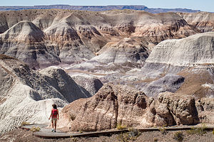 Lolo on the Blue Mesa TrailThis was a big day, one to which I had been looking forward to for many miles and miles – a day of pure fun, with a tiny bit of driving wrapped around it.
We hadn’t been to a new National Park in many years. Actually, technically this was not a new park for us, but I am counting it as such, because we did not give it justice when we passed through here back in 2002 on the way home from one of our aggressive cross country trips. After about 4,500 miles in 2 ½ weeks, trip fatigue had set in, and all I could get the family to do when we got here was to drive to the Kachina Point Lookout and have their picture taken with the colorful badlands of the Painted Desert behind them – cranky faces and forced smiles and all.
Today would be different. We had a whole day to devote to the Park and I was planning on exploring every nook and cranny.
The park is actually divided into 2 sections, divided by I40. The section south of I40 contains one of the world's largest concentrations of petrified wood. North of I40 are the colorful rocks and buttes that make up the badlands of the Painted Desert.
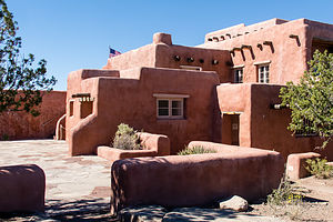 Painted Desert InnThe best way to see the park is to drive the 27-mile park road, stopping at various viewpoints and hikes along the way. We began our tour at the Painted Desert Visitor Center, just a short distance north of I40.
While at the Visitor Center I took note of the Painted Desert Diner behind the gift shop and suggested strongly that we should consider getting lunch there later. But first, we had some exploring to do.
We drove north on the park road, stopping first at the historic Painted Desert Inn, which overlooks the painted desert from Kachina Point – the site of our 2002 family photo. As much as I love pristine, untouched natural beauty, I also love learning about how people interacted with it. The Painted Desert Inn was the perfect place to do just that.
Wandering around inside, we learned a bit of its history from the informative exhibits. Back in 1924, a gentleman named Herbert Lore hired Native Americans to build the original Inn, as a place for travelers along the old Route 66 to stop in for a meal and to shop for Native American crafts. The building was originally constructed using petrified wood, which was abundant in the area.
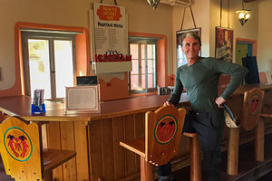 Old Diner in the Painted Desert InnIn 1936, the National Park Service purchased the Inn from Lore and enlarged and renovated it in the pueblo style, covering the petrified-wood walls with stucco. The building was closed during the final years of World War II, but reopened afterwards by the Fred Harvey Company, which hired famed Hopi artist Fred Kabotie to paint several murals inside.
The Inn closed in 1962 when the Painted Desert Visitor Center opened, and plans were made to demolish it because of structural problems. However, forward-thinking people that recognized its unique mixture of Spanish and Native American pueblo styles, as well as the value of Kabotie’s beautiful murals, argued for its preservation.
Today it is a National Historic Landmark restored to its 1940s appearance. It houses the Painted Desert Inn Museum, which celebrates the area’s cultural heritage. The old lunch counter and bar room downstairs are nostalgic to look at, but unfortunately they are just that – historical artifacts. As a hungry traveler, I sure would have liked to sit on a stool at the counter and order lunch for 35 cents, just like back in the 1940s.
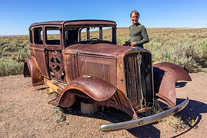 Herb shopping for a new vehicleAfter the Inn, we strolled the short distance out to Kachina Point before getting back in the car to continue along our drive. Right before we got to the overpass over I40, we pulled over to look at an old rusted out car alongside the road, a tribute to old Route 66, which used to travel through the park. It reminded me a bit too much of our Suburban.
It was at this point that I realized that I had made a boo-boo. The only place to eat in the Park was back at the Visitor Center, and the only way to get to the southern section of the park was from where we were right now. There was no way we were going to happily spend a day of hiking and exploring the rest of the park on empty stomachs, so we drove back the 5 ½ miles to the diner in the Visitor Center that I had scouted out earlier in the day.
Being the only game in town, I kind of expected the diner to be a rip-off, but it was unbelievably reasonable and delicious. I had a lamb stew with cornbread for less than $5 and Herb had a meat Navajo taco for about the same.
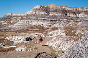 More Blue MesaTummies full, we were ready to set out for a day of exploring the Park. The best way to see it is to drive the 27-mile park road from one entrance to the other. We had already covered the 6 miles of the northern section (twice in, fact), so we retraced our steps, waved hello again to the Suburban’s rusty brethren, and crossed over I40 into the southern part of the park.
About 12 miles south of I40, we turned left off the scenic drive and continued on the Blue Mesa Road to a panoramic overlook atop the mesa. From there we followed a paved path from the mesa top down to the valley floor, winding our way around and amongst the beautiful, blue-, gray-, and white-striped badlands of the Painted Desert. Being amongst them was so much more rewarding than just gazing at them from a scenic viewpoint above.
Their texture was really interesting as well – kind of like elephant-skin. The hills are composed of silt, sand, clay, and gravel, but it is the Bentonite clay in them that gives them both their bluish color and wrinkled appearance – they swell with moisture when the rains come, and then shrink when it dries.
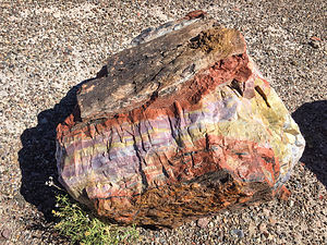 Vibrant colors of a petrified logBesides the beautiful badlands, there were plenty of colorful petrified logs scattered along the edges of the trail, as if they had been split by an ancient lumberjack before turning to stone (the logs that is, not the lumberjack). What a rich pallet of colors. The deep golds, greens, purples, and yellows of the logs, complemented the grays, blues, and browns of the surrounding hillsides beautifully, making them a perfect foreground for a very colorful photo.
The hike was only a mile, but there so much reward along the way.
After Blue Mesa, we drove about 10 miles south on the park road to the Rainbow Forest Museum, near the southern entrance to the park, from which we would start our second hike of the day – the Long Logs Trail to the Agate House Ruins.
From the Rainbow Forest Museum parking lot, we walked east along the park road a short distance to the Long Logs trailhead. From there we headed south on what used to be an old access road. At about ½-mile from the trailhead we came to a junction, and headed right towards the Agate House. We would save the Long Logs Trail for our return.
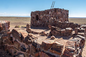 Agate House RuinsIn about ½-mile, we arrived at the Agate House, an 8-room building constructed entirely of chunks of colorful petrified wood. Archaeologists believe that it was occupied between 1050 and 1300 by ancient Pueblo people.
In the 1930s, under the direction of archeologist Cornelius B.Cosgrove, Jr., the ruins of the Agate House were partially reconstructed by the Civil Works Administration. Although it not a completely accurate replication of the original structure, it does give a better idea of what it might have been like to live here 700 years ago.
The house sits upon a knoll overlooking the badlands – I guess even the Pueblo people appreciated a good view. Although it is the only house in sight, the hundreds of similar petrified wood structure sites found throughout the park, show that it was likely once part of a much larger Pueblo community.
We retraced our steps back to the Long Logs trail junction, taking note of the numerous chunks of petrified wood alongside the trail. We looked at them differently now. In the eyes of the ancient Pueblo people, these were not just beautiful objects to look at, but useful building material.
 Long Logs TrailBack at the junction, we took the 0.6-mile Long Logs loop past some of the largest specimens of petrified trees in the park – some as long as 116 feet. Geologists believe that this area was the site of an ancient logjam, where years of floods and mudslides buried a pile of conifer trees, making this one of the largest concentrations of petrified wood in the park.
All in all, the hike to the Agate House and Long Logs was 2.4 miles – once again, a short hike with lots of reward.
For our final activity of the day, we decided to do one of the backcountry “Off the Beaten Path” hikes that required a bit more route finding skills, as there are no set trails or markers. The ranger at the Visitor Center had suggested “Martha’s Butte” as an interesting destination that would take us away from civilization for a bit. Plus, the butte has a solar marker petroglyph, which appears sliced in half (half light / half shade) during the summer solstice sunrise. Hopefully, we would find it.
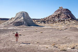 "Off the Beaten Path" to Martha's ButteAs directed by the ranger, we parked at a dirt pullout just before the Dry Wash Bridge near milepost 22. From there we crossed the road and followed the wash north for awhile before it bent sharply to the east. We were now heading northwest towards Martha’s Butte, about a mile away. Once the butte came in sight, it was quite easy to find our way.
There was another smaller hill just south of Martha’s Butte, where we stopped first to admire “Walker’s Stump,” a large petrified log sticking out of the clay hill at a strange angle. It got its name “stump” because it was originally thought to be just that – a petrified stump. However, in 1936, park naturalist Myrl Walker did some excavating and proved that it was just a log embedded in the clay.
When we got to Martha’s Butte, we noticed several scattered boulders at its base adorned with petroglyphs. One spiral one in particular was quite interesting and we wondered whether we had perhaps found the solar marker. Hard to tell when it is neither sunrise nor a summer solstice. However, looking it up later on the internet confirmed that it was indeed the solar marker.
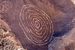 Solar Marker on Martha's ButteWe walked around the entire butte, admiring the many other interesting images carved into the rocks. Most of them were geometric patterns, but there were plenty of birds and four-legged animals as well.
What a great destination, and so secluded. We hadn’t seen another soul the entire time. Plus, it was kind of fun not being confined to a set trail, but being allowed to wander about somewhat aimlessly, just with a general direction in mind.
The whole hike, including our often random rambling, was 2.3 miles with only 40 feet of elevation gain.
I wish we had time to do another “Off the Beaten Path” hike, but it was getting late and time to head on to find a place to stay for the night.
We made one more stop at Newspaper Rock to gaze out over an area of rocks with over 650 petroglyphs carved on their faces. Obviously this area was hugely significant and sacred to the ancestral Pueblo people that called what is now Petrified Forest National Park their home.
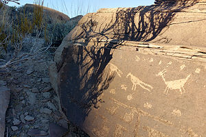 Pueblo artFeeling quite satisfied in having finally given Petrified Forest NP the time and admiration it deserved, we drove to nearby Holbrook, just 20 miles away, and checked into a Travelodge for the night.
From there we later walked to Mesa Italiana, a cozy restaurant, just ¼ mile from our motel, serving pizza, pasta, and other Italian specialties.
What a fabulous day it had been – three great and very distinct hikes with a variety of natural beauty and cultural history, and then Italian food to bring it to a close.
Description
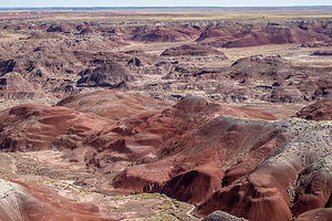 Painted Desert at Petrified Forest NPPetrified Forest National Park, which is located along I40 in eastern Arizona, consists of two main sections. The section south of I40 contains one of the world's largest concentrations of petrified wood. North of I40 are the colorful rocks and buttes that make up the badlands of the Painted Desert.
The best way to see the park is to drive the 27-mile park road from the southern entrance to the north. A good first stop is the Rainbow Forest Museum. Behind the museum is the ½-mile, self-guided Giant Logs Trail, which leads through one of the four major concentrations of petrified logs in the park. The largest petrified log is Old Faithful, which is 9 ½ feet in diameter.
A short spur road leads to Long Logs and the Agate House. At Long Logs there is a ½-mile loop trail that leads through the largest concentration of petrified wood in the park. Some of the logs are as long as 170 feet. The 1-mile-long Agate House Trail leads to an Anasazi pueblo made of petrified wood.
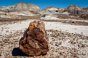 Petrified log imitating a rockContinuing north on the park road, you'll come to the Crystal Forest where the petrified logs were once filled with quartz and amethyst crystals. Although gem hunters have taken most of the crystals before this area was a National Park, there are still some very colorful logs to see along the 0.8-mile loop trail.
Further north, a 3-mile spur road leads to Blue Mesa, with its blue and purple-striped badlands. A fairly difficult, 1-mile loop trail descends into the mesa. Many consider this to be one of the most scenic trails in the park.
The next stop is the Puerco Indian Ruin, the remains of an Anasazi village occupied in the 1100 - 1300s. There are also petroglyphs carved out of the patina of the rocks surrounding the pueblo.
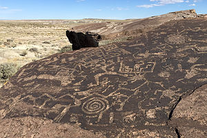 Petroglyphs by Martha's ButteThe park road then crosses I40 and enters the Painted Desert portion of the park. Along the road to the Visitor Center there are 8 overlooks, each affording a different perspective of this colorful landscape. One of the most spectacular is Pintado Point, the highest point along the rim of the Painted Desert. At Kachina Point is the Painted Desert Inn, now closed, and the trailheads for the Painted Desert Wilderness Trail and the Painted Desert Rim Trail. The Wilderness Trail steeply descends in switchbacks down the face of the badlands onto the floor of the Painted Desert. With a backcountry permit, you can camp here and watch the sun set over the badlands. The Rim Trail runs along the rim of the Painted Desert from Kachina to Tawa Point. Along the way there are spectacular views of the colorful badlands of the Painted Desert.
- ‹ previous
- 8 of 11
- next ›
Petrified Forest National Park location map in "high definition"
Javascript is required to view this map.
