- Home
- About
- Map
- Trips
- Bringing Boat West
- Migration West
- Solo Motorcycle Ride
- Final Family XC Trip
- Colorado Rockies
- Graduates' XC Trip
- Yosemite & Nevada
- Colorado & Utah
- Best of Utah
- Southern Loop
- Pacific Northwest
- Northern Loop
- Los Angeles to NYC
- East Coast Trips
- Martha's Vineyard
- 1 Week in Quebec
- Southeast Coast
- NH Backpacking
- Martha's Vineyard
- Canadian Maritimes
- Ocracoke Island
- Edisto Island
- First Landing '02
- Hunting Island '02
- Stowe in Winter
- Hunting Island '01
- Lake Placid
- Chesapeake
- Provincetown
- Hunting Island '00
- Acadia in Winter
- Boston Suburbs
- Niagara Falls
- First Landing '99
- Cape Hatteras
- West Coast Trips
- Burning Man
- Utah Off-Roading
- Maui
- Mojave 4WD Course
- Colorado River Rafting
- Bishop & Death Valley
- Kauai
- Yosemite Fall
- Utah Off-Road
- Lost Coast
- Yosemite Valley
- Arizona and New Mexico
- Pescadero & Capitola
- Bishop & Death Valley
- San Diego, Anza Borrego, Joshua Tree
- Carmel
- Death Valley in Fall
- Yosemite in the Fall
- Pacific Northwest
- Utah Off-Roading
- Southern CA Deserts
- Yosemite & Covid
- Lake Powell Covid
- Eastern Sierra & Covid
- Bishop & Death Valley
- Central & SE Oregon
- Mojave Road
- Eastern Sierra
- Trinity Alps
- Tuolumne Meadows
- Lake Powell Boating
- Eastern Sierra
- Yosemite Winter
- Hawaii
- 4WD Eastern Sierra
- 4WD Death Valley +
- Southern CA Deserts
- Christmas in Tahoe
- Yosemite & Pinnacles
- Totality
- Yosemite & Sierra
- Yosemite Christmas
- Yosemite, San Diego
- Yosemite & North CA
- Seattle to Sierra
- Southwest Deserts
- Yosemite & Sierra
- Pacific Northwest
- Yosemite & South CA
- Pacific Northwest
- Northern California
- Southern Alaska
- Vancouver Island
- International Trips
- Index
- Tips
- Books
- Photos/Videos
- Search
- Contact
Moonscape Overlook, UT
Tuesday, September 12, 2023 - 7:00pm by Lolo
20 miles and 0.5 hours from our last stop - 1 night stay
Travelogue
 Excited Herb at the Moonscape OverlookAfter the Mars Desert Research Station and Long Dong Silver, we drove back on Cow Dung Road to Highway 24 and went east about 7 miles or so before turning right onto the bumpy, dirt Coal Mine Road (also called Factory Butte Road) to get to Factory Butte and the Moonscape Overlook (also called Skyline Rim Overlook).
There are no signs on these roads indicating where anything is, so we had to rely on Google Maps and Gaia to get where we wanted to go.
After driving about 6 miles on Coal Mine Road, Gaia indicated that we should turn right (east) to get to the Skyline Rim Overlook, ignoring the fact that Factory Butte was on our left. Herb and I were confused, as we thought the overlook was going to overlook Factory Butte.
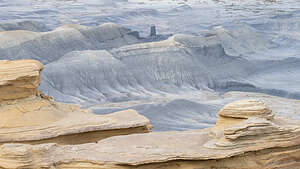
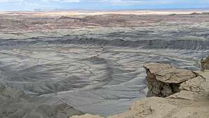
 Moonscape OverlookWe followed Gaia’s instructions and drove east, but saw nothing but a flat expanse ahead of us. In about 2 miles we came to the end of the road, where we found ourselves perched on the edge of a cliff, looking out over an expanse of badlands, known as the Blue Valley, below us and the Henry Mountains in the distance. It was mind blowing.
There was only one other car there, but no visible passenger anywhere. Not sure where they could have possibly gone as there was no way from here to get down into the badlands.
Looking at Herb’s face, I knew this is where we were going to camp for the night.
 Moonscape OverlookWe set out our chairs to settle in for the evening here, and Herb set his tripod up on one of the outcrops over the badlands. Then we sat and watched the light change and took some photos of this breathtaking scenery. .
The light was good, but we knew it was going to be even better in the morning.
We crawled into the back of the 4Runner to get some sleep. The only other vehicle was still empty. Kind of mysterious.
.thumbnail.jpg) Happy Herb camping at MoonscapeThe next morning, before we even got up, we saw several headlights headed our way. By the time we got out of the 4Runner, over a dozen cars were pouring into our little secluded paradise.
Happy Herb camping at MoonscapeThe next morning, before we even got up, we saw several headlights headed our way. By the time we got out of the 4Runner, over a dozen cars were pouring into our little secluded paradise.
Realizing that it was a photo tour group, Herb quickly went out and set up his tripod, claiming the vantage point he wanted for sunrise. We felt we had earned it. Afterall, we slept here all night while all these people were probably in a hotel room.
.thumbnail.jpg) Happy Herb in the morningBut who should we see among the newly-arrived crowd then our friends Kevin and Mark, the two night-sky photographers that we had met at the Goblin Valley Observation Point just last night.
Happy Herb in the morningBut who should we see among the newly-arrived crowd then our friends Kevin and Mark, the two night-sky photographers that we had met at the Goblin Valley Observation Point just last night.
It felt like we were meeting old friends as we shared what we each had done that day and what we had photographed.
Then we got down to business, watching the sun light up the badlands in all their splendor. And we didn’t even have coffee yet!
.thumbnail.jpg) Moonscape in the morningThere were photographers scattered on every outcrop. Some idiots were even climbing up on a precarious narrow spire to take selfies of themselves. You couldn’t pay me enough to risk that for a photo. What a difference from last night when we had the whole place to ourselves.
Moonscape in the morningThere were photographers scattered on every outcrop. Some idiots were even climbing up on a precarious narrow spire to take selfies of themselves. You couldn’t pay me enough to risk that for a photo. What a difference from last night when we had the whole place to ourselves.
Once the sun was up, people started getting back in their cars and driving back towards Factory Butte. Just as quickly as they came, they were gone, and we once again had this lovely place to ourselves.
After a quick breakfast, we got back in the 4Runner and started driving west back towards Factory Butte, with the intention of driving around the entire thing, seeing it from all vantage points.
- ‹ previous
- 9 of 16
- next ›
Moonscape Overlook location map in "high definition"
Javascript is required to view this map.
