- Home
- About
- Map
- Trips
- Bringing Boat West
- Migration West
- Solo Motorcycle Ride
- Final Family XC Trip
- Colorado Rockies
- Graduates' XC Trip
- Yosemite & Nevada
- Colorado & Utah
- Best of Utah
- Southern Loop
- Pacific Northwest
- Northern Loop
- Los Angeles to NYC
- East Coast Trips
- Martha's Vineyard
- 1 Week in Quebec
- Southeast Coast
- NH Backpacking
- Martha's Vineyard
- Canadian Maritimes
- Ocracoke Island
- Edisto Island
- First Landing '02
- Hunting Island '02
- Stowe in Winter
- Hunting Island '01
- Lake Placid
- Chesapeake
- Provincetown
- Hunting Island '00
- Acadia in Winter
- Boston Suburbs
- Niagara Falls
- First Landing '99
- Cape Hatteras
- West Coast Trips
- Burning Man
- Utah Off-Roading
- Maui
- Mojave 4WD Course
- Colorado River Rafting
- Bishop & Death Valley
- Kauai
- Yosemite Fall
- Utah Off-Road
- Lost Coast
- Yosemite Valley
- Arizona and New Mexico
- Pescadero & Capitola
- Bishop & Death Valley
- San Diego, Anza Borrego, Joshua Tree
- Carmel
- Death Valley in Fall
- Yosemite in the Fall
- Pacific Northwest
- Utah Off-Roading
- Southern CA Deserts
- Yosemite & Covid
- Lake Powell Covid
- Eastern Sierra & Covid
- Bishop & Death Valley
- Central & SE Oregon
- Mojave Road
- Eastern Sierra
- Trinity Alps
- Tuolumne Meadows
- Lake Powell Boating
- Eastern Sierra
- Yosemite Winter
- Hawaii
- 4WD Eastern Sierra
- 4WD Death Valley +
- Southern CA Deserts
- Christmas in Tahoe
- Yosemite & Pinnacles
- Totality
- Yosemite & Sierra
- Yosemite Christmas
- Yosemite, San Diego
- Yosemite & North CA
- Seattle to Sierra
- Southwest Deserts
- Yosemite & Sierra
- Pacific Northwest
- Yosemite & South CA
- Pacific Northwest
- Northern California
- Southern Alaska
- Vancouver Island
- International Trips
- Index
- Tips
- Books
- Photos/Videos
- Search
- Contact
Manuel F. Correllus State Forest, MA
Saturday, July 5, 2008 - 11:45am by Lolo
0 miles and 0 hours from our last stop - 1 night stay
Travelogue
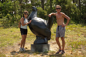
 Lolo and Herb with Booming Ben SculptureAlthough the State Forest is technically part of Edgartown and West Tisbury, I felt that it was unique enough to warrant its own stop. Its 5,100 acres take up a major part of the center of the island.
We have come to the forest many times to bike its 15 miles of trails, some of which parallel the roads, but others that take you through the heart of the forest. One time Herb and I even roller bladed the trails while the kids biked. Although the island is flat, there are quite a bit of roller coaster ups and downs along this trail.
There is even a 27-basket Frisbee golf course, located inside the forest on Barnes Road near the airport. A few years back, we bought some discs for the boys in a shop in Edgartown. For those unfamiliar with the game, it is played similar to golf, but instead of hitting a golf ball, one throws a special type of Frisbee (called a disc). The object is to get the disc into a raised basket in as few throws as possible. The other object, we soon found, was to not land a poorly thrown disc in the poison ivy that grows quite bountifully throughout the forest. It was pretty fun, but completing all 27 holes can take a very long time, so we usually choose a shortened version.
I wish I had researched the background of this state forest earlier. We have been coming to it for over 30 years, but it wasn’t until this year – when I finally decided to do a writeup on Martha’s Vineyard – that I discovered its interesting history.
The Massachusetts Department of Conservation and Recreation is working on trying to restore the park’s native ecosystem in what is one of the largest environmental restoration projects in the country. The park is part of the Atlantic coastal pine barrens ecoregions and includes grasslands, heathlands, pine barrens, and woodlands. It was originally set aside as a preserve in 1908 in an attempt to save the endangered heath hen, an eastern subspecies of the prairie chicken, which had died out in most other areas of the northeast.
The rest is a very sad story. At first things were going pretty well, and the heath hen population grew from 70 to 2,000. However, a few bad years of forest fires and severe winters reduced the population to only 12. By the next year there was only one poor male heath hen left. Okay, now here comes the really sad part. He is nicknamed Booming Ben, because he used to perch himself atop an oak tree and let out his mating call, which raises the question, “if a heath hen booms in the forest, but no female heath hen hears it, does it make a sound?” Boomer lived on another four or so years by himself before passing in 1932, making the heath hen species extinct.
I really would have liked to have known about this story earlier. From now on, I am going to do more heavy research upfront, so I can get the full enjoyment out of a stop and not just save that for my readers.
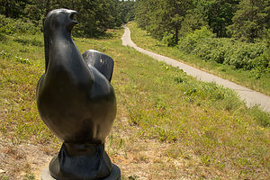
On our most recent trip to the Vineyard in 2012, we made it a mission to find the Heath Hen Sculpture put here in 2011 by the artist Todd McGrain. We found it, just out there along the path through the forest in the spot where Boomer (as Herb was now calling him) was last seen – about a 10-minute walk from Gate 18 or 19 on the West Tisbury-Edgartown Road. It certainly made me view the forest quite differently—not as just a place for recreation, but as a home to a broad range of species, some of which are quite rare.
It is really a lovely and serene place, and so different from the rest of the island. That is one thing that I definitely have to say about Martha’s Vineyard. There is so much diversity in landscapes that you can achieve a lot more variety of experiences than you would expect on a small island.
Description
 "Boomer" and State Forest TrailThe Correllus State Forest is a 5,100-acre preserve in the center of Martha’s Vineyard, managed by the Department of Conservation and Recreation. Its main attraction is the 15 miles of bike paths through lovely woodlands.
The preserve was created in 1908 as a sanctuary for the endangered heath hen, an eastern subspecies of the prairie chicken, which had died out in most other areas of the northeast. At first efforts were successful and the heath hen population grew from 70 to 2,000. However, as a results of forest fires and severe winters, by 1927 there were only 12 heath hens left in the world, all in the Correllus State Forest. By the following year there was only one male heath hen left, nicknamed Booming Ben, because of the way he would sit perched atop an oak tree futiley emitting the heath hen mating call. Sadly, there were no female heath hens to hear his plea. When Booming Ben disappeared in 1932, the species that had once been a source of food for settlers from Virginia to Maine was now extinct. In June of 2011, Sculptor Todd McGrain’s Heath Hen Sculpture was dedicated and placed in the forest near where Booming Ben was last seen. The sculpture can be found by taking a 10-minute walk from Gate 18 or 19 on the West Tisbury-Edgartown Road.
In 1934 the Civilian Conservation Corps planted red pine, white pine, and spruce trees to an area that had become a sandplain grassland because of frequent fires. While the white pine and spruce trees are still flourishing, the red pine, which thrives in colder climates, is dying out. Today the forest is the focus of one of the largest environmental restoration projects in the nation as work is done to restore it to its native ecosystem.
Bicycling, hiking, or rollerblading through the state forest is a wonderful way to get away from the crowds that descend on the island during the summer months. The following is a link to the state forest’s trail map: http://www.mass.gov/dcr/parks/trails/corellus600.gif
As an added attraction is the 27-basket disc (Frisbee) golf course located inside the forest on Barnes Road near the airport. For those unfamiliar with the game, it is played similar to golf, but instead of hitting a golf ball, one throws a special type of Frisbee (called a disc). The object is to get the disc into a raised basket in as few throws as possible.
- ‹ previous
- 5 of 8
- next ›
Manuel F. Correllus State Forest location map in "high definition"
Javascript is required to view this map.
