- Home
- About
- Map
- Trips
- Bringing Boat West
- Migration West
- Solo Motorcycle Ride
- Final Family XC Trip
- Colorado Rockies
- Graduates' XC Trip
- Yosemite & Nevada
- Colorado & Utah
- Best of Utah
- Southern Loop
- Pacific Northwest
- Northern Loop
- Los Angeles to NYC
- East Coast Trips
- Martha's Vineyard
- 1 Week in Quebec
- Southeast Coast
- NH Backpacking
- Martha's Vineyard
- Canadian Maritimes
- Ocracoke Island
- Edisto Island
- First Landing '02
- Hunting Island '02
- Stowe in Winter
- Hunting Island '01
- Lake Placid
- Chesapeake
- Provincetown
- Hunting Island '00
- Acadia in Winter
- Boston Suburbs
- Niagara Falls
- First Landing '99
- Cape Hatteras
- West Coast Trips
- Burning Man
- Utah Off-Roading
- Maui
- Mojave 4WD Course
- Colorado River Rafting
- Bishop & Death Valley
- Kauai
- Yosemite Fall
- Utah Off-Road
- Lost Coast
- Yosemite Valley
- Arizona and New Mexico
- Pescadero & Capitola
- Bishop & Death Valley
- San Diego, Anza Borrego, Joshua Tree
- Carmel
- Death Valley in Fall
- Yosemite in the Fall
- Pacific Northwest
- Utah Off-Roading
- Southern CA Deserts
- Yosemite & Covid
- Lake Powell Covid
- Eastern Sierra & Covid
- Bishop & Death Valley
- Central & SE Oregon
- Mojave Road
- Eastern Sierra
- Trinity Alps
- Tuolumne Meadows
- Lake Powell Boating
- Eastern Sierra
- Yosemite Winter
- Hawaii
- 4WD Eastern Sierra
- 4WD Death Valley +
- Southern CA Deserts
- Christmas in Tahoe
- Yosemite & Pinnacles
- Totality
- Yosemite & Sierra
- Yosemite Christmas
- Yosemite, San Diego
- Yosemite & North CA
- Seattle to Sierra
- Southwest Deserts
- Yosemite & Sierra
- Pacific Northwest
- Yosemite & South CA
- Pacific Northwest
- Northern California
- Southern Alaska
- Vancouver Island
- International Trips
- Index
- Tips
- Books
- Photos/Videos
- Search
- Contact
Indianapolis KOA, IN
Tuesday, June 25, 2013 - 10:00am by Lolo
175 miles and 3 hours from our last stop - 1 night stay
Travelogue
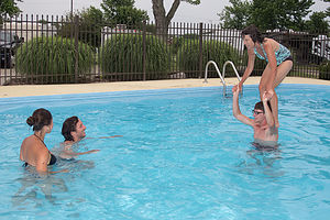
 Lolo ready for a Chicken FightThree hours of driving was about all we wanted to do after starting so late in the day, but it at would put a few more miles under our belt so that the next day’s drive to Lake Anita in Iowa wouldn’t be so grueling. The always handy Woodall Guide helped me find a KOA with a pool just outside of Indianapolis and not too far off of I70. We usually like to get into camp by no later than 6:30, so that we have a chance to relax and have a nice dinner. Also, I thought the pool sounded pretty good on such a hot day.
The pool was fun. Somehow Tommy convinced me to stand on his shoulders and take on Andrew and Celeste in a chicken fight. I am definitely getting too old for this, but as long as the boys think of me as young enough to do something as stupid as this, I wasn’t about to change their minds. I must say that being around them always makes me feel about 20 years younger.
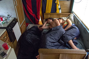
 Kids and Celeste Sleeping in RV KitchenStorm clouds were moving in, so we went back to our campsite so that Andrew and Celeste could set up their tent before the rain started. This was to be our first night of camping, and the plan for the trip was Andrew and Celeste would camp in a tent, and Tommy would sleep on the dinette bed. The bed over the cab was out of commission due to the tons of stuff we were transporting cross country. In fact, to make matters worse, much of their stuff was spilling over into the main part of the RV. Celeste had a yoga block the size of a small coffee table and Tommy had a computer case equally as large. The evening ritual included lugging these items into the driver and passenger seat of the motorhome, so that we could at least maneuver around the RV, which seemed to be shrinking in size as each day passed.
Our outdoor dining was cut short by mosquitoes and the threat of rain, so we moved inside. It was kind of cozy, so much so that Andrew and Celeste decided it would be nicer to sleep in the RV too. That began the new sleeping arrangement – Andrew and Celeste mushed on the dinette and Tommy (always the good sport) on the floor between the dinette and the refrigerator. This was going to be a very long trip.
- ‹ previous
- 2 of 15
- next ›
Indianapolis KOA location map in "high definition"
Javascript is required to view this map.

