- Home
- About
- Map
- Trips
- Bringing Boat West
- Migration West
- Solo Motorcycle Ride
- Final Family XC Trip
- Colorado Rockies
- Graduates' XC Trip
- Yosemite & Nevada
- Colorado & Utah
- Best of Utah
- Southern Loop
- Pacific Northwest
- Northern Loop
- Los Angeles to NYC
- East Coast Trips
- Martha's Vineyard
- 1 Week in Quebec
- Southeast Coast
- NH Backpacking
- Martha's Vineyard
- Canadian Maritimes
- Ocracoke Island
- Edisto Island
- First Landing '02
- Hunting Island '02
- Stowe in Winter
- Hunting Island '01
- Lake Placid
- Chesapeake
- Provincetown
- Hunting Island '00
- Acadia in Winter
- Boston Suburbs
- Niagara Falls
- First Landing '99
- Cape Hatteras
- West Coast Trips
- Burning Man
- Utah Off-Roading
- Maui
- Mojave 4WD Course
- Colorado River Rafting
- Bishop & Death Valley
- Kauai
- Yosemite Fall
- Utah Off-Road
- Lost Coast
- Yosemite Valley
- Arizona and New Mexico
- Pescadero & Capitola
- Bishop & Death Valley
- San Diego, Anza Borrego, Joshua Tree
- Carmel
- Death Valley in Fall
- Yosemite in the Fall
- Pacific Northwest
- Utah Off-Roading
- Southern CA Deserts
- Yosemite & Covid
- Lake Powell Covid
- Eastern Sierra & Covid
- Bishop & Death Valley
- Central & SE Oregon
- Mojave Road
- Eastern Sierra
- Trinity Alps
- Tuolumne Meadows
- Lake Powell Boating
- Eastern Sierra
- Yosemite Winter
- Hawaii
- 4WD Eastern Sierra
- 4WD Death Valley +
- Southern CA Deserts
- Christmas in Tahoe
- Yosemite & Pinnacles
- Totality
- Yosemite & Sierra
- Yosemite Christmas
- Yosemite, San Diego
- Yosemite & North CA
- Seattle to Sierra
- Southwest Deserts
- Yosemite & Sierra
- Pacific Northwest
- Yosemite & South CA
- Pacific Northwest
- Northern California
- Southern Alaska
- Vancouver Island
- International Trips
- Index
- Tips
- Books
- Photos/Videos
- Search
- Contact
Cottonwood Canyon Road, Wahweap Hoodoos, and Old Paria, UT
Wednesday, May 19, 2021 - 5:45pm by Lolo
240 miles and 7 hours from our last stop - 1 night stay
Travelogue
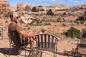 Not a bad view at Kiva KoffeehouseAfter Herb removed me kicking and screaming from the lovely Boulder Mountain Lodge, we continued our journey with the plan of driving the Cottonwood Canyon Road through the Grand Staircase-Escalante National Monument to Kanab.
Our drive along very scenic highway 12 brought us to another highly recommended stop - the Kiva Koffeehouse in Escalante, a beautiful building that blended into the surrounding landscape with fabulous views from its outdoor dining area.
We were not the only ones that had this idea. The line was quite long and the wait for our food was even longer. However, we had no reason to complain, as we had managed to nab two chairs overlooking the red and white striated sandstone rock formations that we had grown so accustomed to over the past week.
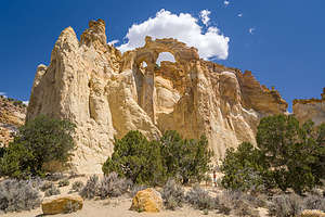 Grosvenor Arch along the Cottonwood Canyon RoadThe final result was a great cup of coffee (mine an indulgent mocha with chocolate) and two salads with chicken to go - perhaps our dinner later tonight.
From there we continued along Route 12 to the town of Cannonville, where we turned off, passing right by Kodachrome Basin State Park (surprise surprise - no vacancy in the campground) to the start of the Cottonwood Canyon Road, a 46-mile drive on a well-graded dirt road, ending at Route 89 between the towns of Big Water and Kanab.
Compared to what we had been driving on, the road was very easy - much less bouncing and climbing. No need for me to get out of the truck to guide Herb over rock ledges.
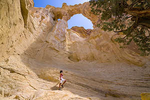 Grosvenor Arch along the Cottonwood Canyon Road10 miles into the drive, we took the turnoff for the one-mile spur road to Grosvenor Arch, a unique sandstone double arch, 90 feet across, and 152 feet above the ground. An easy asphalt path led right up to the arch, but we ventured a little further to get right under it.
In 1949, the arch was named after Gilbert Hovey Grosvenor, president of the National Geographic Society and the first-time editor of the National Geographic magazine.
About 3 ½ miles south of the turnoff for Grosvenor Arch, we came to an area with colorful badlands to the east, referred to as Candyland because of its white and red rocks and pinnacles. It was pretty much high noon right now, so the stark lighting was not doing it the justice it deserved.
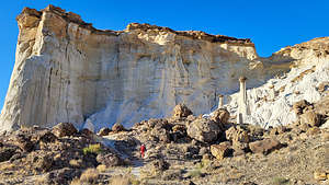 Approaching the Wahweap HoodoosTo the west was the Coxcomb, an elongated series of upwardly-pointed ridges that ran parallel to our drive.
The thing that ruined the drive a bit for us after being out in such remote places for the past week, were the very prominent power lines that ran along the entire drive, making it very difficult not to include them in a photo.
Rather than camp along the drive and do the recommended hike to Yellow Rock, we decided to go the whole way and try to find the Wahweap Hoodoos, which we had seen photos of in our Photography Guide.
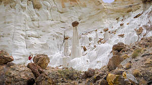 Wahweap HoodoosThe directions were quite complicated, but fortunately we had the Gaia app, which pretty much has every remote road, hiking trail, attraction, etc. There were two ways to get there. One was a longer, rougher drive, but only required a 1-mile hike to the main hoodoo area, and the other one was a shorter, easier drive, but it required a 4 ½ mile (each way) hike to best hoodoos.
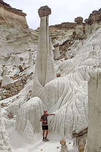 The Big FellaWe were very comfortable handling the more difficult road, so we chose the shorter hike direction. Gaia was great. I could follow our progress along the way on my phone, seeing every dirt turnoff we passed. That combined with the written directions in our photography guide brought us to the fence along the Wahweap Wash, with a sign instructing us now to drive in the wash.
The skies were getting ominous and we could see dark clouds and virga in the distance. I have been dying to use the word virga since we learned it a few days back from a park volunteer at the Great Gallery. It means rain that evaporates before reaching the ground.
I had seen photos of the Wahweap Hoodoos, but nothing had prepared me for the surreal otherworldliness. We felt like we had taken a wrong turn and landed on another planet - or better yet, a Dr. Seuss book.
 Wahweap HoodoosThey seemed to spring out of nowhere after making a slight right into an alcove about a mile down a rather prosaic wash. There were about a dozen white hoodoos, but one in particular dominated the scene, rising about 30 feet in the air, topped by its little brown cap.
We’ve seen lots of strange rock formations in the west, but these topped the cake. Plus, it was the whitest rock I have ever seen, except maybe for the tufa castles in mono lake.
These particular hoodoos (also called spires, columns, pillars, and even goblins) were formed from a relatively soft, bright white entrada sandstone with a harder layer of dakota sandstone protecting them from erosion. Over millions of years, weathering has created these amazing formations. The brown caps of stone atop the towers are the harder, less easily erodable dakota sandstone. Hoodoos such as this are mainly found in dry, hot areas.
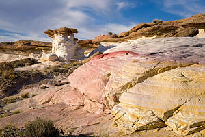 Interesting formation near our campsiteGeology is amazing, giving even Michelangelo a run for his money in creating wonders out of stone.
Those ominous clouds were getting closer and darker, so I kept trying to hurry Herb along, which he hates. I definitely think he wanted to spend more time there.
Time to find camping for the night, so we drove back a few miles from whence we came, but this time we turned left on the White Sands Jeep Trail, a very rough 4WD road which we learned about in our photography guide. After 1.3 very rocky, bumpy miles we came to a promontory that looked out over a small canyon that had some impressive, colorful hoodoos just under the rim. We had found our home for the night.
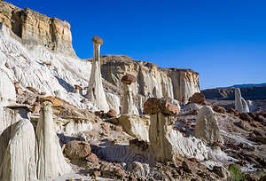 More Wahweap HoodoosAlthough it didn’t rain, it became extremely windy, to the point where we had to remain in the car, making brief forays out along the canyon rim to visit the little hoodoos.
The next morning, I felt really bad having rushed Herb away from the Wahweap Hoodoos, so we drove back for one more visit. Although they are supposedly best photographed in morning light, I think the drama of yesterday’s dark storm clouds created a better mood and background for these alien-like formations.
From the Wahweap Hoodoos we drove back along BLM roads to the Cottonwood Canyon Road and then out to Highway 89. I have a predilection towards culture and human history with a really nice natural backdrop, so I suggested to Herb that we go to Old Paria where Western movies used to be filmed. Our photography guide showed an awesome photo of an old western building used in the movies with multicolored butte in the background.
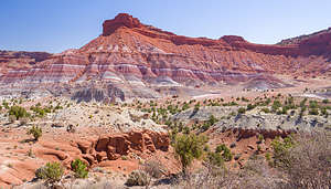 Along the scenic road to the Old Paria movie setUnfortunately, I didn’t read the fine print that building did not exist anymore. However, the drive along the dirt BLM 585 road, which traces the colorful red, white, and purple Chinle formation badlands was worth it. Also, for future reference we found some great dispersed camping sites.
There was, however, an interesting old cemetery with 20 graves of early settlers who tried to eke out a living in this desolate, yet beautiful, area.
From here we weren’t sure what to do. We were supposed to be in Bishop tomorrow night for my son’s birthday, which was about an 8 hour drive away.. We could take our time getting there or go the distance today.
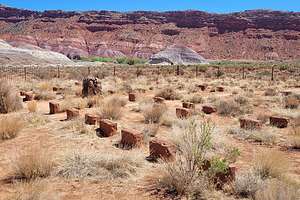 Old Paria CemeteryWe figured we would just start driving that way and see what we felt like.
We were really getting into this eating lunch out thing, so we stopped in the town of Hurricane at the Main Street Cafe, which turned out to be a truly wonderful dining experience. The food was delicious, but it was really the ambience that felt so right. There was a lovely breeze on the outdoor patio, which was surrounded by green lawn and trees, something I didn’t realize how much I missed until now. It reminded me a bit of Key West, which is crazy, as the towns couldn’t be more different.
It was only 6 ½ hours to Bishop, so we decided to go for it. The problem was that that lovely breeze we had enjoyed so much at lunch wasn’t so lovely anymore.
- ‹ previous
- 7 of 8
- next ›
Cottonwood Canyon Road, Wahweap Hoodoos, and Old Paria location map in "high definition"
Javascript is required to view this map.
