- Home
- About
- Map
- Trips
- Bringing Boat West
- Migration West
- Solo Motorcycle Ride
- Final Family XC Trip
- Colorado Rockies
- Graduates' XC Trip
- Yosemite & Nevada
- Colorado & Utah
- Best of Utah
- Southern Loop
- Pacific Northwest
- Northern Loop
- Los Angeles to NYC
- East Coast Trips
- Martha's Vineyard
- 1 Week in Quebec
- Southeast Coast
- NH Backpacking
- Martha's Vineyard
- Canadian Maritimes
- Ocracoke Island
- Edisto Island
- First Landing '02
- Hunting Island '02
- Stowe in Winter
- Hunting Island '01
- Lake Placid
- Chesapeake
- Provincetown
- Hunting Island '00
- Acadia in Winter
- Boston Suburbs
- Niagara Falls
- First Landing '99
- Cape Hatteras
- West Coast Trips
- Burning Man
- Utah Off-Roading
- Maui
- Mojave 4WD Course
- Colorado River Rafting
- Bishop & Death Valley
- Kauai
- Yosemite Fall
- Utah Off-Road
- Lost Coast
- Yosemite Valley
- Arizona and New Mexico
- Pescadero & Capitola
- Bishop & Death Valley
- San Diego, Anza Borrego, Joshua Tree
- Carmel
- Death Valley in Fall
- Yosemite in the Fall
- Pacific Northwest
- Utah Off-Roading
- Southern CA Deserts
- Yosemite & Covid
- Lake Powell Covid
- Eastern Sierra & Covid
- Bishop & Death Valley
- Central & SE Oregon
- Mojave Road
- Eastern Sierra
- Trinity Alps
- Tuolumne Meadows
- Lake Powell Boating
- Eastern Sierra
- Yosemite Winter
- Hawaii
- 4WD Eastern Sierra
- 4WD Death Valley +
- Southern CA Deserts
- Christmas in Tahoe
- Yosemite & Pinnacles
- Totality
- Yosemite & Sierra
- Yosemite Christmas
- Yosemite, San Diego
- Yosemite & North CA
- Seattle to Sierra
- Southwest Deserts
- Yosemite & Sierra
- Pacific Northwest
- Yosemite & South CA
- Pacific Northwest
- Northern California
- Southern Alaska
- Vancouver Island
- International Trips
- Index
- Tips
- Books
- Photos/Videos
- Search
- Contact
Cabot Landing Provincial Park, NS
Friday, July 16, 2004 - 4:00am by Lolo
50 miles and 1.25 hours from our last stop
Travelogue
We left the Cabot Trail in the village of Cape North and headed towards the northernmost tip of Cape Breton island. The drive took us along mountains and rugged coastline before descending into the small community of Sugar Loaf in the Aspy Valley. This section of Cape Breton Island is quite remote and undeveloped, much like the Cabot Trail was 30 years ago, before being discovered by travel magazines.
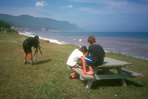
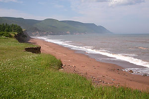
 Bluff overlooking the beachWe stopped at the Cabot Landing Provincial Picnic Park to have lunch. It was a very small park with a few picnic tables perched on a bluff overlooking Aspy Bay and a beach with sand redder than any I have ever seen before. It was quite lovely. Although it wasn’t warm enough to tempt us to dive into the surf, we did take a long walk along the beach, taking many photographs along the way. On our way back, we noticed the small black head of a seal bobbing playfully out in the surf. I think he was actually more interested in us than we were in him. He took a particular liking to Tommy, whom he followed up and down the beach. I suggested to Tommy that he put on his black wetsuit and join him, but he wasn’t buying it.
After lunch, we strolled over to the bust of Giovanni Cabot, the Italian explorer who was credited with discovering Canada back in 1497. Apparently there is quite a controversy as to where he first made landfall, and places such as Newfoundland, Labrador, and even Maine claim that it was on their shores. However, locals here like to believe that Cabot first touched shore in this very park.
Description
 Bluff overlooking the beachCabot’s Landing Provincial Park is located in the village of Sugar Loaf, on the northernmost tip of Cape Breton Island. It is reached by leaving the Cabot Trail at the village of Cape North and heading north towards Bay St. Lawrence.
This beautiful picnic park features a mile-long red sand beach on Aspy Bay. There is also a bust of the Italian explore Giovanni Cabot (John Cabot) who is believed to have landed here in 1497.
- ‹ previous
- 9 of 23
- next ›
Cabot Landing Provincial Park location map
Javascript is required to view this map.
