- Home
- About
- Map
- Trips
- Bringing Boat West
- Migration West
- Solo Motorcycle Ride
- Final Family XC Trip
- Colorado Rockies
- Graduates' XC Trip
- Yosemite & Nevada
- Colorado & Utah
- Best of Utah
- Southern Loop
- Pacific Northwest
- Northern Loop
- Los Angeles to NYC
- East Coast Trips
- Martha's Vineyard
- 1 Week in Quebec
- Southeast Coast
- NH Backpacking
- Martha's Vineyard
- Canadian Maritimes
- Ocracoke Island
- Edisto Island
- First Landing '02
- Hunting Island '02
- Stowe in Winter
- Hunting Island '01
- Lake Placid
- Chesapeake
- Provincetown
- Hunting Island '00
- Acadia in Winter
- Boston Suburbs
- Niagara Falls
- First Landing '99
- Cape Hatteras
- West Coast Trips
- Burning Man
- Utah Off-Roading
- Maui
- Mojave 4WD Course
- Colorado River Rafting
- Bishop & Death Valley
- Kauai
- Yosemite Fall
- Utah Off-Road
- Lost Coast
- Yosemite Valley
- Arizona and New Mexico
- Pescadero & Capitola
- Bishop & Death Valley
- San Diego, Anza Borrego, Joshua Tree
- Carmel
- Death Valley in Fall
- Yosemite in the Fall
- Pacific Northwest
- Utah Off-Roading
- Southern CA Deserts
- Yosemite & Covid
- Lake Powell Covid
- Eastern Sierra & Covid
- Bishop & Death Valley
- Central & SE Oregon
- Mojave Road
- Eastern Sierra
- Trinity Alps
- Tuolumne Meadows
- Lake Powell Boating
- Eastern Sierra
- Yosemite Winter
- Hawaii
- 4WD Eastern Sierra
- 4WD Death Valley +
- Southern CA Deserts
- Christmas in Tahoe
- Yosemite & Pinnacles
- Totality
- Yosemite & Sierra
- Yosemite Christmas
- Yosemite, San Diego
- Yosemite & North CA
- Seattle to Sierra
- Southwest Deserts
- Yosemite & Sierra
- Pacific Northwest
- Yosemite & South CA
- Pacific Northwest
- Northern California
- Southern Alaska
- Vancouver Island
- International Trips
- Index
- Tips
- Books
- Photos/Videos
- Search
- Contact
Auburn, CA
Sunday, September 29, 2013 - 4:00pm by Lolo
91 miles and 2 hours from our last stop - 2 night stay
Travelogue
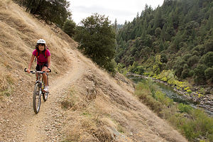
 Lolo Biking the Lake Clementine TrailWe really had no plans from here, other than flying out of SF Airport in 5 days – very unlike my usual anal-retentive planning. Now that we weren’t racing back and forth across the country every vacation, our travels were taking on a different feel, more relaxed and spontaneous. Also, since we knew we would be coming out this way again and again to see the boys, missing something this time was not a big deal, as we would just hit it the next time. I think we are going to like this new toned down pace.
Herb came up with the idea for this stop. He loves river running, and the American River, which flows through the Auburn State Recreation Area, is supposed to be one of the best places in California to do that. This time of year was wrong for that, not enough water flowing, but we thought we could at least check it out for the future, and besides, Auburn had lots of other recreational opportunities that are good all year round, such as mountain biking and hiking.
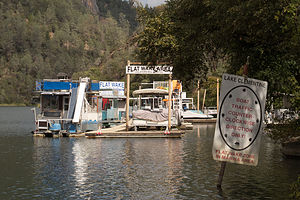
 Lake Clementine MarinaWe found the Auburn Gold Country RV Campground through a search on Google Maps. The owner was extremely helpful in providing us with trail maps and mountain biking suggestions in the nearby Auburn State Recreation Area. That night we relaxed by the campground pool, reviewing the trails, and making our decision for the next day’s adventure.
The directions for the trailhead for the lake Clementine Trail were extremely detailed, but we still screwed up and found ourselves biking for a mile or so down the wrong trail. Finally realizing we had made a mistake, we rode back to the car, remounted our bikes on the rack, and started all over again. I think the mix-up was that there is both a Foresthhill and an Old Foresthill Road.
Anyway, we finally found the correct trailhead and spent the morning on a really nice ride atop the riverbank of the North Fork of the American River. There were a few places, however, where the trail narrowed and dropped off much too sharply for my comfort level, so I got off and walked the bike a few times to avoid plunging into the river.
 Herb Biking the North Fork of the American RiverThe trail map was very detailed and pointed out some nice stops we would have missed along the way, such as Clarks Hole. Without knowing that this stop would be in ¾ mile, we would have missed the short, steep side trail down to a pool and a sandy beach. The trail was much too steep for bikes, so we left them on top of the riverbank and walked down. It was a lovely spot, popular for swimming in the summer, but a bit too chilly now.
Continuing upriver, the trail transitioned from a narrow, bumpy dirt trail to a shaded, smoother dirt roadway, which was once the old stagecoach route connecting Auburn with other gold rush camp towns in the mid to late-1800s. The better surface would have made the ride easier except for the fact that now it began to climb quite steeply and continued to do so until we reached Lake Clementine Road, where the trail officially ends. From there we followed the paved roadway for about ¼ mile to an unmarked side trail on the left, which led to a great view of the water cascading over the North Fork Dam, on the southern end of the lake, and the reason this lake is here in the first place.
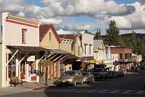
 Broad Street Nevada CityThis is an out and back ride, so from there we turned around and went back from whence we came, enjoying it much more, as most of it in this direction was downhill.
There was still a lot of time left in the day, so we decided to take the 25-mile drive up Route 49 to Nevada City, another historic Gold Rush boom town, which was also a nominee for Outside Magazine’s 2012 ”The Best Town Ever” award.
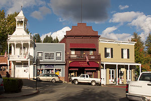
I do have a soft spot for quaint old historic towns and this one was a gem. We picked up a Walking Tour Map at the Chamber of Commerce and wandered up and down its quaint streets, which really do have the feel of an old mining town.
It’s hard to believe that this was once the third largest city in California and home to 10,000 boisterous souls --miners, saloon keepers, shopkeepers, prostitutes, and every other provider of necessities for men with new found riches in their pockets. Today it’s a quiet little town of 2,800 residents, who have had the smarts to recognize that their new source of wealth is the town’s remarkable history and charm, and they have done an excellent job at restoring and preserving that. Today the entire downtown area is listed as a national historic landmark.
Still, I would have to say that although it’s a nice place to visit, I wouldn’t want to live here. It's just a little too small and out of the way for me.
Description
 Main Street Nevada CityAuburn is located about 30 miles northeast of Sacramento via I80. Considered by many to be the adventure capital of California, it is home each year to the Western States Endurance Run/Ultra Marathon and the grueling Western States Endurance Ride. It is also rated one of the best places to live in Northern California.
Like many other cities in California, Auburn’s start was triggered by gold. However, unlike most of the other boom and bust Gold Rush towns, it survived by becoming a major supply and trading center. After a series of fires in the 1850s destroyed many of the wooden buildings in town, the townspeople rebuilt them in brick. You can see many of these restored buildings when visiting Historic Old Town.
While miners originally came to this area to pan for gold in the American River, today outdoor enthusiasts flock to the area to enjoy its recreational treasure – the Auburn State Recreation Area, which encompasses 35,000 acres along 40 miles of the North and Middle forks of the American River. The confluence of the North and Middle Forks is one of the most popular areas for swimming, fishing, and access to the many mountain biking and hiking trails in the Auburn SRA. Also, the American River is a premier river running destination with class II, III, and IV runs.
- ‹ previous
- 16 of 19
- next ›
Auburn location map in "high definition"
Javascript is required to view this map.
