- Home
- About
- Map
- Trips
- Bringing Boat West
- Migration West
- Solo Motorcycle Ride
- Final Family XC Trip
- Colorado Rockies
- Graduates' XC Trip
- Yosemite & Nevada
- Colorado & Utah
- Best of Utah
- Southern Loop
- Pacific Northwest
- Northern Loop
- Los Angeles to NYC
- East Coast Trips
- Martha's Vineyard
- 1 Week in Quebec
- Southeast Coast
- NH Backpacking
- Martha's Vineyard
- Canadian Maritimes
- Ocracoke Island
- Edisto Island
- First Landing '02
- Hunting Island '02
- Stowe in Winter
- Hunting Island '01
- Lake Placid
- Chesapeake
- Provincetown
- Hunting Island '00
- Acadia in Winter
- Boston Suburbs
- Niagara Falls
- First Landing '99
- Cape Hatteras
- West Coast Trips
- Burning Man
- Utah Off-Roading
- Maui
- Mojave 4WD Course
- Colorado River Rafting
- Bishop & Death Valley
- Kauai
- Yosemite Fall
- Utah Off-Road
- Lost Coast
- Yosemite Valley
- Arizona and New Mexico
- Pescadero & Capitola
- Bishop & Death Valley
- San Diego, Anza Borrego, Joshua Tree
- Carmel
- Death Valley in Fall
- Yosemite in the Fall
- Pacific Northwest
- Utah Off-Roading
- Southern CA Deserts
- Yosemite & Covid
- Lake Powell Covid
- Eastern Sierra & Covid
- Bishop & Death Valley
- Central & SE Oregon
- Mojave Road
- Eastern Sierra
- Trinity Alps
- Tuolumne Meadows
- Lake Powell Boating
- Eastern Sierra
- Yosemite Winter
- Hawaii
- 4WD Eastern Sierra
- 4WD Death Valley +
- Southern CA Deserts
- Christmas in Tahoe
- Yosemite & Pinnacles
- Totality
- Yosemite & Sierra
- Yosemite Christmas
- Yosemite, San Diego
- Yosemite & North CA
- Seattle to Sierra
- Southwest Deserts
- Yosemite & Sierra
- Pacific Northwest
- Yosemite & South CA
- Pacific Northwest
- Northern California
- Southern Alaska
- Vancouver Island
- International Trips
- Index
- Tips
- Books
- Photos/Videos
- Search
- Contact
20 Lakes Basin, CA
Sunday, July 19, 2020 - 6:30pm by Lolo
60 miles and 1.5 hours from our last stop
Travelogue
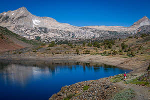 20 Lakes Basin HikeWe had managed to get a Yosemite day permit so that we could drive through Tuolumne Meadows to get home. These day permits were implemented during Covid to restrict the number of people visiting the park each day. It does not, however, allow you to stay overnight in the park, for that you need a camping reservation. The Tuolumne Meadows Campground wasn’t even open this summer anyway, so there really was no place to stay.
I suggested we do a hike on the way home, so we chose an old favorite from many years ago - the 20 Lakes Basin hike, a very popular 8.4 mile loop hike route past 8 beautiful alpine lakes. Not sure why it’s called 20 Lakes Basin, but I imagine you can lengthen the hike to find the other 12.
The hike is technically not in Yosemite, but just outside its eastern boundary in the Hoover Wilderness Area. Since it was outside the park, we thought maybe we could camp there after we finished our hike.
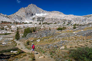 20 Lakes Basin HikeHowever, apparently, so did everyone else. Every possible spot there was to pull over was already taken by someone that obviously planned to spend the night there. Oh well. We would just do the hike and then continue on home.
The trail begins at the southern end of 10,087-foot-high Saddlebag Lake near the Resort parking area. There is a water taxi which goes between the Resort and the far north end of the lake, saving hikers about a mile and a half. Back in 2015, the cost of the ferry was $8 one-way or $13 round-trip. Not sure what it is now.
Since we were there to hike, we skipped the water taxi and headed off along the suggested eastern shore of the lake, which although slightly longer than the trail along the western shore, offers more scenic views.
Once we reached the ferry dock at the northern end of the lake (at about 2.2 miles) we chose to do the loop in a clockwise direction. The trail gradually began to ascend as we approached tiny Wasco Lake at 10,325 feet.
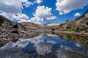 20 Lakes Basin HikeThe trail continued on relatively flat terrain to the larger Steelhead Lake with breathtaking views of North Peak and the granite summit of Shepherd Crest.
After passing a small, unnamed lake (I was still counting it though), we continued through a pretty meadow along a talus slope to Shamrock Lake whose shores were ringed by rocky meadows and stunted white-bark pines growing amidst its granite ledges. North Peak and Mount Conness loomed towards the southwest.
At 4.5 miles, we were slightly past our halfway mark and we had already passed 6 lakes. At this point, the trail got a bit sketchy as we descended the headwall to the basin that cradles Shamrock and Steelhead Lakes towards Helen Lake, which would be the northernmost point of our hike before heading back towards Saddlebag Lake. The trail required a bit of rock scrambling on scree-covered slopes and the crossing of a creek to get around the northern end of Helen Lake. We were back at 10,107 feet, about the elevation we had started at.
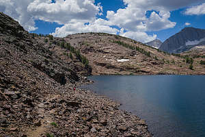 20 Lakes Basin HikeAt the northeast end of Helen Lake, we came to a trail junction. To the left, was the trail towards Lundy Canyon and to the right the continuation of our loop hike back to Saddlebag Lake.
From the trail junction, we turned right and proceeded up a steep rocky gorge towards Odell Lake, another pretty alpine lake tucked in a rocky bowl and surrounded by steep multi-hued cliffs.
Then it was on and up through Lundy Pass at 10,345 feet before descending once more to pretty little Hummingbird Lake nestled in a shallow bowl beneath Tioga Crest.
We continued descending to a trail junction near the northern end of Saddlebag Lake. Although we were quite tired, we didn’t even consider taking the ferry back as we wanted to complete the loop as a hike.
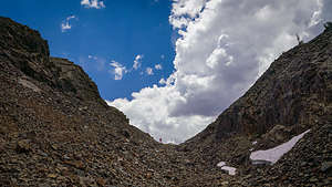 Up the rocky gorge on the 20 Lakes Basin hikeThe trail along the western shore was nothing like the smooth dirt road we had started out on along the eastern side of the lake. It was very rocky and not exactly what I was looking for at this late point in the hike.
However, we soon were back at the Saddlebag Resort, pleasantly exhausted after what was a really spectacular hike – 8.8 miles, 928 feet of elevation gain, 9 beautiful alpine lakes, and breathtaking views all along the way.
All in all, a very good day, except for the fact that we still had to drive home.
- ‹ previous
- 6 of 6
20 Lakes Basin location map in "high definition"
Javascript is required to view this map.
