- Home
- About
- Map
- Trips
- Bringing Boat West
- Migration West
- Solo Motorcycle Ride
- Final Family XC Trip
- Colorado Rockies
- Graduates' XC Trip
- Yosemite & Nevada
- Colorado & Utah
- Best of Utah
- Southern Loop
- Pacific Northwest
- Northern Loop
- Los Angeles to NYC
- East Coast Trips
- Martha's Vineyard
- 1 Week in Quebec
- Southeast Coast
- NH Backpacking
- Martha's Vineyard
- Canadian Maritimes
- Ocracoke Island
- Edisto Island
- First Landing '02
- Hunting Island '02
- Stowe in Winter
- Hunting Island '01
- Lake Placid
- Chesapeake
- Provincetown
- Hunting Island '00
- Acadia in Winter
- Boston Suburbs
- Niagara Falls
- First Landing '99
- Cape Hatteras
- West Coast Trips
- Burning Man
- Utah Off-Roading
- Maui
- Mojave 4WD Course
- Colorado River Rafting
- Bishop & Death Valley
- Kauai
- Yosemite Fall
- Utah Off-Road
- Lost Coast
- Yosemite Valley
- Arizona and New Mexico
- Pescadero & Capitola
- Bishop & Death Valley
- San Diego, Anza Borrego, Joshua Tree
- Carmel
- Death Valley in Fall
- Yosemite in the Fall
- Pacific Northwest
- Utah Off-Roading
- Southern CA Deserts
- Yosemite & Covid
- Lake Powell Covid
- Eastern Sierra & Covid
- Bishop & Death Valley
- Central & SE Oregon
- Mojave Road
- Eastern Sierra
- Trinity Alps
- Tuolumne Meadows
- Lake Powell Boating
- Eastern Sierra
- Yosemite Winter
- Hawaii
- 4WD Eastern Sierra
- 4WD Death Valley +
- Southern CA Deserts
- Christmas in Tahoe
- Yosemite & Pinnacles
- Totality
- Yosemite & Sierra
- Yosemite Christmas
- Yosemite, San Diego
- Yosemite & North CA
- Seattle to Sierra
- Southwest Deserts
- Yosemite & Sierra
- Pacific Northwest
- Yosemite & South CA
- Pacific Northwest
- Northern California
- Southern Alaska
- Vancouver Island
- International Trips
- Index
- Tips
- Books
- Photos/Videos
- Search
- Contact
Stonewall Jackson Lake State Park
Friday, August 16, 2002 - 11:00am by Lolo550 miles and 10 hours from our last stop - 1 night stay
Travelogue
Our trip was nearly over now and we were into the final stretch. A long day of driving brought us to this pretty state park in the heart of West Virginia--our last stop before reaching home. It was actually quite nice, with campsites perched alongside the edge of a very pretty lake. Unfortunately, there was no beach area to swim from by the campground.
Although we were just passing through, it was obvious that most of our fellow campers were here for longer stays and that the park was a destination in itself, with boating, fishing, etc. These were the kind of campgrounds I like to wander around at night admiring all the homey touches the campers have added--which Herb finds so tacky. You know, little Budweiser lights hanging from the canopies, cutesy signs identifying the campers within, etc.
Well, this was it--the end of the journey. By late afternoon tomorrow we would be home again.
Description
Stonewall Jackson Lake State Park in the heart of West Virginia was named for the famous U.S. General whose boyhood home was not far from the park.
The main attraction in the park is the 2,650-acre Stonewall Jackson Lake, constructed in the mid-1980s by the US Army Corps of Engineers. Facilities include a marina, boat docks, fishing pier, and boat rentals (including 4 houseboats).
There is a 34-site campground with full hookups located right on the lake.
Friends Driveway in Western KY / Land Between the Lakes
Wednesday, August 14, 2002 - 11:30am by Lolo400 miles and 7 hours from our last stop - 2 night stay
Travelogue
After a long drive, we arrived at the home of some very good friends that had moved to western Kentucky several years ago. Ed had been Herb's rock climbing buddy for close to 10 years, spending every weekend together climbing the Shawnagunk Mountains in New Paltz, New York. Then, to our dismay, he moved with his family to Kentucky to take a position as a biology professor at Murray State University.
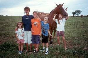 Kids with Kentucky HorseWhat a different lifestyle from New Jersey--14 acres of land, horse farms next door, no traffic. They loved it and I can see why. We found a level spot in their driveway and parked our "house on wheels" (as Ed's kids called it). We spent two wonderful nights visiting and catching up on old times.
Ed, who is a biology professor at Murray State University, gave us a tour of the college. The kids' favorite part of the tour by far was Ed's lab where they were enthralled by his vast collection of snakes and lizards. Ed promised to send them a baby corn snake when the one in his lab had its babies--great! I'll have to have a little talk with Ed.
The next day, Ed took us on an outing to Land Between the Lakes National Recreation Area, which is only about a 30 minutes drive from his home. This peninsula of land between Kentucky Lake and Lake Barclay is a recreational mecca with great fishing, camping, swimming, hiking, and much more. After a refreshing swim in Lake Barclay, we decided to visit the Elk and Bison Range within the park. After paying our $3 a carload, we entered the gates of this restored habitat hoping to see a bison. We were not disappointed--almost immediately, one planted itself on the road in front of us and settled down for a rest. After patiently waiting for about 10 minutes for it to move, Ed told us he would use his vast knowledge of the animal kingdom to deal with the situation (after all, he has a PhD in Biology). We watched in awe as he rolled down his window, stuck his head out, and spoke to the bison--"You're ugly!" I think I could have done that without the eight years of schooling. The taunt had absolutely no effect, so we settled back to wait him out. After a few minutes and on its own terms, the bison slowly got up and walked off the road.
Description
 Herb tossing Tommy in Lake BarclayThe Land Between Lakes (known locally as LBL) is a 170,000 acre National Recreation Area that lies on a narrow strip of land between Lake Barkley and Kentucky Lake in Trigg and Lyon Counties in Kentucky and Stewart County in Tennessee. The park was created in 1961 by President John F. Kennedy with the intent that it be used by the Tennessee Valley Authority as a demonstration in resource development. Today, the park is wholly owned by the federal government. The last private residents left in 1970.
There is much recreational activity to enjoy in the park. Besides the boating, fishing, and watersports available on the lakes, there are over 200 miles of hiking, mountain biking, horseback, and off-highway vehicle trails that are open year round. Other popular outdoor activities include camping, hunting, wildlife viewing, and photography. In addition to the wildlife native to the area, LBL maintains herds of bison and elk in a 750-acre habitat restoration area that visitors can drive through.
Other interpretive facilities include the Golden Pond Planetarium and Observatory, which offers planetarium shows and telescope viewing sessions; the Homeplace-1850, a living history farm demonstrating the life of an 1850s farm family; and the Nature Station, an environmental education center which leads wildlife viewing hikes.
Lake Dardanelle State Park
Tuesday, August 13, 2002 - 11:30am by Lolo75 miles and 1.5 hours from our last stop - 1 night stay
Travelogue
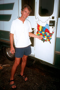 Herb with the Last State of the Lower 48 stickerHere we were in Arkansas, the final state in our quest for completing the lower 48. I'm not sure what we expected, having never really given Arkansas much thought. In many ways it seemed very familiar, much more like home than any other place we'd been to in the last few weeks. There were mountains and lakes, and for the first time in awhile, grass and trees. Everything was so green--very different from the browns and reds of the Southwest and the golden grass of the plains. It felt good to be here, which must mean that we were about ready to go home.
The park was actually quite lovely with a beautiful man-made lake surrounded by mountains. The scenery would have been even more idyllic if hadn't been for the nuclear power plant on the far shore spewing white clouds from its huge chimney. It reminded me of a Homer Simpson episode. We just angled our chairs a little and pretended it wasn't there.
That night was a big event in our RV history--the filling in of the final state on our RV map of the continental U.S. Originally, I had felt silly about the idea of collecting states just for the sake of collecting them, but it had turned out differently than I expected. In the process of visiting states that we would never have visited otherwise, we had found some true gems. And as a bonus, the kids really knew their U.S. geography now.
As Herb placed Arkansas on the map, he turned to us and said, "Now we can sell the RV." I think he was just kidding. I hope so because I'm just getting started...
Description
Lake Dardanelle State Park is located in central Arkansas about 2 miles south of I40. It is surrounded by the Ouachita Mountains to the south and the Boston Mountain Range of the Ozarks to the north. However, its main attraction is the 34,000-acre man-made lake, formed by the Arkansas River, which is very popular for fishing, boating, and swimming.
Facilities include picnic areas, boat launches, a marina, miniature golf, and a 97-site campground.
Fort Smith National Historic Site
Tuesday, August 13, 2002 - 8:00am by Lolo270 miles and 4.75 hours from our last stop
Travelogue
As we drove across the Arkansas River into Arkansas (all 4 of us crammed into the cab), we entered the last of the 48 Continental U.S. states needed to fill out our RV map. Quite an accomplishment in 4 years, if I must say so myself.
Shortly after entering Arkansas, we stopped at the Fort Smith National Historic Site, the site of one of the first U.S. military posts in the Louisiana Territory. We were greeted quite enthusiastically by the ranger in the Visitor Center who appeared quite excited to see a group of tourists. It actually was a very nicely done museum with exhibits focusing on the turbulent years between the U.S. government and the Indians in the newly acquired Louisiana Territory. The fort was also home to the Federal Court that had jurisdiction over the Indian Territory. We visited the recreated federal court and jail and the kids' personal favorite--the gallows where 79 convicted criminals were executed.
The boys were quite happy and surprised to find that the gift shop sold hat pins to add to their ever-growing collection.
Description
The town of Fort Smith on the Arkansas River in western Arkansas was founded in 1817 as an Army outpost on the eastern edge of Indian Territory. It quickly grew into a rowdy town full of saloons and brothels as it attracted outlaws and drifters. Today the Visitor Center is located in a former brothel, known as Miss Laura's, in the old 1890s River Front Hotel.
The nearby Fort Smith National Historic Site was the site of one of the first U.S. military posts in the new Louisiana Territory. While only the foundation stones from the original 1817 fort remain, the barracks which contained the Federal courtroom of Judge Isaac C. Parker still stands. Visitors can tour the recreated courtroom, jail, and gallows where 79 criminals were executed.
Oklahoma Route 66 Museum
Tuesday, August 13, 2002 - 3:30am by Lolo15 miles and 0.25 hours from our last stop
Travelogue
We woke up to even stronger winds than the night before and some very ominous clouds. Fearing we would be dodging tornadoes our entire drive through Oklahoma, I was very anxious to get moving. Herb and the kids, however, insisted that I was overreacting and that we should stop, as planned, at the Oklahoma Route 66 Museum.
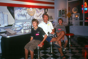 Route 66 TouristsThere are several Route 66 museums throughout the country, but this one is supposed to be one of the best, a real tribute to America's first transcontinental highway. Even the building itself is a Route 66 icon, with its chrome finish and neon and fluorescent lights beckoning the weary traveler to come on in.
I was relieved to notice that none of the employees seemed at all concerned about the weather--I guess they get pretty used to it out here. Based on one of the tour guide's recommendations, we wisely rented the audio tour of the museum, and I'm glad we did. It gave us a very informative narration of the chronological history of the highway. Wearing our headphones, we strolled through the museum, which was laid out in an interesting fashion with each room representing a different decade in the life of Route 66. There was a VW van that spanned the 60s and 70s room. The part of the van in the 60's room was a hippy wagon. Some other highlights included an authentic replication of a classic roadside diner and a drive-in style theater showing vintage Route 66 footage.
The gift shop had some great Route 66 memorabilia--signs, license plates, clocks, knick-knacks, postcards, books, mugs, etc.
It was definitely a worthwhile stop. When we exited the museum, we saw that there had been no improvement in the weather. The skies were very dark and the winds were getting even stronger. We got back on I40 and started heading east as fast as we could.
Description
The Oklahoma Route 66 museum in Clinton, Oklahoma, is the state's official showcase of its Route 66 heritage. The museum building itself, with its neon and fluorescent lights, looks like a Route 66 icon.
Inside, visitors wander through the various rooms, each one representing a different decade, while listening to headphones narrating a chronological history of the highway. Some highlights include an authentic replication of a classic roadside diner and a drive-in style theater showing vintage Route 66 footage.
Elk City / Clinton KOA
Monday, August 12, 2002 - 12:00pm by Lolo165 miles and 3 hours from our last stop - 1 night stay
Travelogue
It felt like Oklahoma. I'm not sure why I thought that--we had never been to Oklahoma before, but it just did. The winds were picking up arousing my fears that we would be dodging tornadoes as we crossed the state--I tend to be rather weather phobic.
We stopped for the night at a KOA along I40 in western Oklahoma set in the middle of some very pretty farmland. We sat by the pool, watching the cottonwood trees throughout the campground swaying in the breeze. Something was brewing. That evening I settled down with my weather radio, as I often do, to see what was going on. My worst fears were realized--severe thunderstorms and possible tornadoes were predicted for tonight and the next day. Images from the Weather Channel flashed before me. Why was I the only one concerned? Much to the Herb's amusement, I went to sleep that night clutching my weather radio, listening to the thunder rumbling in the distance.
Description
The Elk City/Clinton KOA is a 90 site campground right off I40. It has a nice pool and pleasant sites.
Cadillac Ranch
Monday, August 12, 2002 - 5:15am by Lolo170 miles and 3 hours from our last stop
Travelogue
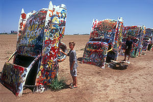 Boy's painting desert cadillacsFrom the beginning of this year's trip, I had told the kids that today would be the highlight of this year's travels--Cadillac Ranch. I don't think they quite believed me. It was pretty cool though. For those of you unfamiliar with Amarillo, Texas's most famous landmark, it's a piece of landscape art featuring ten classic Cadillacs buried nose-down in the dirt with their upended tail fins tracing the design changes that Cadillac made over the years. The ranch is owned by an eccentric Amarillo helium millionaire named Stanley Marsh II. Did you know that 99% of the world's helium is produced in Amarillo, Texas? Neither did we. Well anyway, in 1974 he hired some San Francisco artists to create this very unique piece of art.
Cadillac Ranch is not hard to get to--in fact, it's visible right from I40. Since just seeing it whiz by from the highway wasn't fulfilling enough, we pulled off I40 onto Hope Road where we could park and get the full experience. There it was, like some bizarre Stonehenge, looming out of a very dusty field. As we strolled the 100 yards across the field, laden with cameras and camcorders to immortalize the experience, the wind picked up covering us with dust. This is not exactly a beautiful part of the country.
When we got to the Cadillacs, the kids were delighted to find spray paint cans just begging to be used--Marsh actually encourages people to make their own artistic statement on the cars. The boys added their names to the hundreds of other travelers that preceded them. Actually, Andrew only added his first initial because he ran out of paint.
Having left our mark in the art world, we continued eastward on I40 towards Oklahoma.
Description
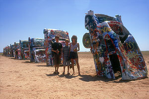 10 classic desert cadillacsThis is Amarillo Texas's most famous landmark. It's a piece of landscape art featuring ten classic Cadillacs (ranging from 1948 to 1964) buried nose-down in the dirt with their upended tail fins tracing the design changes that Cadillac made over the years.
Cadillac Ranch is owned by the eccentric Amarillo helium millionaire, Stanley Marsh III (99% of the world's helium is produced in Amarillo, Texas). In 1974, Marsh hired a group of San Francisco artists to create Cadillac Ranch. The cars were bought from local junkyards and used car lots for about $200 apiece.
Cadillac Ranch is located just 200 yards off I-40 at the Hope Road exit, 5 miles west of Amarillo. Visitors are welcome anytime and are even encouraged to use spray paint to make their own artistic statement.
Santa Rosa Lake State Park
Sunday, August 11, 2002 - 11:00am by Lolo200 miles and 4 hours from our last stop - 1 night stay
Travelogue
As we drove along I-40 across New Mexico, I began my daily search for a campground facility that would provide the most overall happiness for the family--not always a simple task since we often have different criteria. Herb always wants a natural setting with great views for his well-deserved cocktail after a hard day of driving, the kids want amusement of some sort, whether it be natural or man-made, and I want a place that will keep everyone from complaining.
Our first inclination was to find a commercial campground with a pool so that the kids could burn off some pent-up energy and have fun. With that intention in mind, we pulled in the one that was rated pretty good in the campground guide. It was flat, open, and so windy that you could barely see through the swirls of dust. We just couldn't do it. There had to be something better than this. Tommy was mad because he really wanted to swim and thought that the pool--that you could barely see through the dust clouds--looked like fun. He was overruled and we continued on to Santa Rosa Lake State Park, which had a lake to swim in according to the campground guide. This way everyone would be happy. Herb would have his view and the kids could swim.
It's very difficult to get a true sense of a place from the campground guides. Although Santa Rosa Lake State Park had a campground and a 3,800-acre lake, the campground was situated way up on a hill overlooking the lake, which was about a mile away. It was close to dinner time, we were tired from driving, and there was just no easy access from the campground to the lake. Tom pouted over our decision to leave the campground with the pool, but that's the way it goes.
It was extremely windy, so Andrew tried to make the best of it by creating a new sport--wind skateboarding. He took a large beach towel, placed one end of it under his foot on the board, held the other end high over his head, and tried to sail. Even though he didn't go too fast, it got Tommy out of his bad mood and family harmony was resumed.
Description
Santa Rosa Lake State Park is located in eastern New Mexico, about 7 miles north of I-40. The focal point of the park is the very pretty 3,800-acre reservoir, which is surrounded by rocky hills covered in juniper and pinion trees. The reservoir was created from the Pecos River for the purpose of flood control and irrigation.
Today the reservoir is very popular for fishing (bass, walleye, channel catfish, and crappies), boating, water skiing, windsurfing, canoeing, and bird watching (bald eagles, falcons, and osprey). Swimming is also popular although there are no designated swimming areas or sandy beaches along its rocky shoreline.
Facilities include a 76-site campground with some electrical hookups, picnic areas, boat ramps, and hiking trails.
El Malpais National Monument
Sunday, August 11, 2002 - 3:00am by Lolo80 miles and 1.5 hours from our last stop
Travelogue
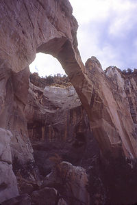 Lolo's solo photo of La Ventana Natural ArchThere was so much to see and do along I40 that if we stopped at all the sights, we'd never get home. We decided to skip El Morro National Monument this time and stop at El Malpais National Monument instead. There were two separate approaches to visiting El Malpais. Highway 53 led to the privately-owned Bandera Crater and Ice Caves. Although that sounded interesting, we decided to stick with the federally-owned portion along Highway 117. We tend to shy away from commercial establishments in natural areas--usually they're a rip-off.
Our first stop along 117 was the Sandstone Bluffs Overlook where we had sweeping views of the cinder cones and lava flows that make up El Malpais. I guess it was the barrenness of this landscape that caused the Spanish to name this land El Malpais, which means "badlands."
We continued on to the parking lot for La Ventana Natural Arch, the second largest natural arch in New Mexico. After a picnic lunch, I suggested to the family that we take the short ½-mile hike to the base of the arch where we would get a much better perspective of it. They weren't buying it. After this morning's fiasco in Red Rock State Park where one of my short hikes turned into a multi-hour adventure (we got lost), no one was interested in another one of my short hikes. So, I took the cameras and went alone. I stood with satisfaction under the broad expanse of the arch and took the classic photograph of the sky through the arch. Maybe I'll show it to them and maybe I won't.
Description
El Malpais National Monument, located in the lava beds of western New Mexico, is considered one of the best examples of volcanic landscapes in the U.S. El Malpais, which means "the badlands" in Spanish, encompasses over 100,000 acres of sandstone cliffs and arches, cinder cones, lava flows, a 17-mile-long lava-tube system, Anasazi ruins, and even some ice caves.
There are two approaches to visiting El Malpais. The first approach is to take Highway 53, just west of Grants, to the privately owned Bandera Crater and Ice Caves. The National Park Service is currently trying to acquire this land, but until do, there is an admission fee to hike up to the crater or walk to the edge of the ice caves. The second approach to visiting El Malpais is to take Highway 117, about 7 miles east of Grants. Along this road is the Sandstone Bluffs Overlook from which there are panoramic views of the volcanic landscape and the La Ventana Natural Arch, the second largest natural arch in New Mexico. An easy ½ mile trail leads to the base of this 165-foot arch.
The 7.5-mile-long (one way), fairly difficult Zuni-Acoma Trail connects Highways 53 and 117. This ancient Puebloan trade route traverses El Malpais and crosses four major lava flows.
Red Rock State Park
Saturday, August 10, 2002 - 11:30am by Lolo80 miles and 1.5 hours from our last stop - 1 night stay
Travelogue
It was late afternoon when we pulled into Red Rock State Park, a few miles off I40 near the town of Gallup, New Mexico. We had already had a very full day--over 6 hours of driving with stops at Walnut Canyon and Petrified Forest. Herb was fried and ready to just settle down to a cold beer, some good music, and a view. Well, that's exactly what he got. From the back windows of our RV, there was an incredible view of a natural amphitheater, surrounded on three sides by red sandstone cliffs and buttes, with an interesting rock formation called Church Rock perched on the top of the cliff. Perfect!
 Old Farts at Red RockBeing the hyperactive tourist I am, I just couldn't relax until I had explored a little and seen what this place had to offer. Besides, I had noticed an awful lot of activity in the parking lot in the day use area when we pulled in, so the kids and I just had to check it out, leaving Herb behind to unwind.
We were amazed with what we found! Set into the beautiful red sandstone cliffs of the Park was an 8,000-seat arena, and that night it was playing host to an Intertribal Indian Ceremonial Dance of some sort. I called Herb on the walkie-talkies to tell him of our find, but he wasn't budging. He reminded me that it was getting late and we hadn't even had dinner yet. Unable to overcome our curiosity, the kids and I went to the entrance of the arena to take a peek. A brief peek was all we got before we were asked to present our tickets. Since all I had in my pocket was $5 and we were starving, we said, "No Thank You," and headed back to the RV.
 Red RockLater, when I found out what a big deal this event was, I really regretted having missed it. It's one of the oldest and largest gatherings of Indian tribes in the nation, and it's been an annual event since 1922. Each year more than 14 tribes, each wearing its own distinctive dress, gather in Red Rock State Park to dance and, sell arts and crafts--and we didn't even know all this was going on just 100 yards from our campsite. I guess one of the disadvantages to winging an itinerary is not knowing enough about the places you decide to stop at.
The next morning we rose early to the sight of a colorful hot hair balloon floating through the amphitheater near Church Rock. Not a bad way to start your day.
Before leaving Red Rock and continuing our drive east, we decided to take a quick hike up to Church Rock, about 2 miles away. There was no real marked trail leading up to it, but it wasn't as if we could miss it--it was pretty prominent. So, we just walked along the canyon floor and then scrambled up some slick rock to its base.
Then came our mistake--walking around the base of it without taking note of where we started. When it was time to descend, we each had a different idea of what direction we should take. It was like picking which spoke of a wheel to follow, and it all looked the same. My idea was to replay the video footage we had taken when we climbed up to try to recognize how the rock formation looked, but I guess Herb felt that this was the male equivalent of asking for directions and said it wasn't necessary. Knowing that he, by far, had the best sense of direction in the family, we followed his lead and tried to look for familiar stuff along the way. I was pretty worried because I knew that even a slightly wrong angle could lead us pretty far off course over the 2 miles we had to cover. Things got pretty tense on the way down as the kids and I started to panic that we actually were lost. Luckily, Herb kept his cool, but I think even he was starting to get a bit concerned.
Finally, we saw a road in the distance. This was both a good thing and a bad thing--bad because there had not been a road on our way up to Chimney Rock meaning we were lost, but good because at least we had found civilization. Getting to the road was a little rough going, but Tommy found a way for us to bushwhack down. As we stepped onto the deserted road and practically kissed the macadam in gratitude, the kids asked, "Which way?" "That way," said Herb and I, each pointing in different directions like characters in a Bugs Bunny cartoon. Bowing to Herb's better sense of direction, we headed towards the right. Herb ran ahead to make sure that we didn't go too far in the wrong direction. I had a different approach--I flagged down the first car I saw and asked for directions. Herb's instinct was right, and I just pretended I never had any doubts.
Description
Red Rock State Park is located just a few miles off I40 near the town of Gallup, New Mexico. The park has an 8,000-seat arena which is home to the Annual Lions Club Rodeo (considered one of the best in the state) as well as the Annual Intertribal Indian Ceremonial held each year in August. This event includes colorful Indian dances from various tribes and booths selling Indian foods, jewelry, and crafts.
 Red RocksNear the arena is a large, well-equipped campground set in a natural amphitheater, surrounded on three sides by red sandstone cliffs and buttes.
From the campground, trails lead into the amphitheater to Native American petroglyphs and to the most prominent rock formation in the park, Church Rock.
