- Home
- About
- Map
- Trips
- Bringing Boat West
- Migration West
- Solo Motorcycle Ride
- Final Family XC Trip
- Colorado Rockies
- Graduates' XC Trip
- Yosemite & Nevada
- Colorado & Utah
- Best of Utah
- Southern Loop
- Pacific Northwest
- Northern Loop
- Los Angeles to NYC
- East Coast Trips
- 1 Week in Quebec
- Southeast Coast
- NH Backpacking
- Martha's Vineyard
- Canadian Maritimes
- Ocracoke Island
- Edisto Island
- First Landing '02
- Hunting Island '02
- Stowe in Winter
- Hunting Island '01
- Lake Placid
- Chesapeake
- Provincetown
- Hunting Island '00
- Acadia in Winter
- Boston Suburbs
- Niagara Falls
- First Landing '99
- Cape Hatteras
- West Coast Trips
- Maui
- Mojave 4WD Course
- Colorado River Rafting
- Bishop & Death Valley
- Kauai
- Yosemite Fall
- Utah Off-Road
- Lost Coast
- Yosemite Valley
- Arizona and New Mexico
- Pescadero & Capitola
- Bishop & Death Valley
- San Diego, Anza Borrego, Joshua Tree
- Carmel
- Death Valley in Fall
- Yosemite in the Fall
- Pacific Northwest
- Utah Off-Roading
- Southern CA Deserts
- Yosemite & Covid
- Lake Powell Covid
- Eastern Sierra & Covid
- Bishop & Death Valley
- Central & SE Oregon
- Mojave Road
- Eastern Sierra
- Trinity Alps
- Tuolumne Meadows
- Lake Powell Boating
- Eastern Sierra
- Yosemite Winter
- Hawaii
- 4WD Eastern Sierra
- 4WD Death Valley +
- Southern CA Deserts
- Christmas in Tahoe
- Yosemite & Pinnacles
- Totality
- Yosemite & Sierra
- Yosemite Christmas
- Yosemite, San Diego
- Yosemite & North CA
- Seattle to Sierra
- Southwest Deserts
- Yosemite & Sierra
- Pacific Northwest
- Yosemite & South CA
- Pacific Northwest
- Northern California
- Southern Alaska
- Vancouver Island
- International Trips
- Index
- Tips
- Books
- Photos/Videos
- Search
- Contact
I40 to Tucumcari, NM
Monday, May 4, 2015 - 2:30pm by Herb
438 miles and 8.5 hours from our last stop - 1 night stay
Travelogue
 Texas Style BBQFully revived from my two night stay and the services of an able masseuse I was once again, eager to hit the road.
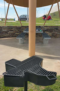
Today ride didn't promise any spectacular scenery, and would hopefully be little more than blasting down the flat straight highway of I40 across the state of Texas. You knew your were in Texas when the Rest Area BBQ grates were in the shape of the state, and the Men's room had all caps TORNADO SHELTER signage as well.
This part of the country is, after all, also known as Tornado alley and weather was one of my major concerns on this stretch of road. Thankfully, I had had little in the way of rain on my trip so far. The forecast for the next few days showed a high likelihood of rain with thunderstorms, possibly severe, but not with any Tornados in the current forecast.
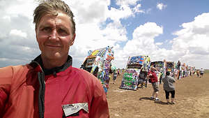
I headed out optimistically, and set my first destination as Cadillac Ranch in Amarillo, Texas. For those unfamiliar with Cadillac Ranch, this is basically an outdoor art exhibit on the ranch of Amariilo's helium magnate Stanley Marsh III. It consists of ten classic Cadillacs, buried nose first into the ground. Spray paint cans are usually found around the base of the vehicles, and visitors are encouraged to leave their own mark on the eclectic exhibit.
We had visited this as a family before in 2002 and curious readers can read Lolo's more detailed description at Cadillac Ranch, TX.
 Desert Cadillac Selfie with PhotobomberI parked my trusty steed sporting a NJ license plate, and strolled out to take the required cell phone selfie at the head of the line of Cadillacs.
Quickly back on the road I was up to my cruising speed of between 75 and 80 mph,, or so says my GPX track and Google Earth. I don't remember usually riding that fast, but there were some impressive storm clouds growing to the south, and I was hoping to outrun them before experiencing them first hand.
In fact, I was not the only one noticing the storm clouds to the south of my position on I40. Lorry had been tracking my progress on Google Maps, and had a weather radar window open as well. By checking them both, she could tell better than I could what my weather forecast would be.
The phone rang in my headset,, and I answered to hear Lolo offering mileages to the next few rest stops where I should stop and shelter out the storm that was rapidly approaching. Thanking her profusely, I headed toward the next rest area, but not before being caught in a deluge and gusty winds that threatened to blow me out of my lane. Within 15 minutes however I was safely in a rest area, enjoying a cup of bad coffee and listening to the rain pound on the ceiling above.
 Honda ST1100 under Ominous SkiesWithin a half hour, all was well again weatherwise and Lorry had another suggestion. We had never really done justice to Petrified Forest National Park, and since I would be passing right by, might I want to go and check it out. Maybe it was too late in the day, or maybe I was wanted to put in some miles, but for whatever reason I decided to blow off the Park and save it for another day. (Lorry and I did get a chance to go back to Petrified Forest National Park in 2016 when we drove the Camry cross country. It was a great visit, and I'm glad we go to do it together).
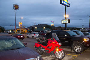
I finally struggled into the town of Tucamari, NM. Got some gas and beer and checked into a Days Inn on the highway. Dinner was at the highly regarded "Blakes Lotaburger" where I tried my first green chile burger. After stolling back to the motel, and a few beers I was ready for bed but not before seeing the local weather forecast for tomorrow as "Thunderstorms in the morning, then partly cloudy during the afternoon hours. A few storms may be severe. High 73F. Winds S at 10 to 20 mph. Chance of rain 80%".
I fell into a deep sleep with the sound of rain blowing on my ground floor window.
- ‹ previous
- 8 of 16
- next ›
I40 to Tucumcari location map in "high definition"
Javascript is required to view this map.
