- Home
- About
- Map
- Trips
- Bringing Boat West
- Migration West
- Solo Motorcycle Ride
- Final Family XC Trip
- Colorado Rockies
- Graduates' XC Trip
- Yosemite & Nevada
- Colorado & Utah
- Best of Utah
- Southern Loop
- Pacific Northwest
- Northern Loop
- Los Angeles to NYC
- East Coast Trips
- 1 Week in Quebec
- Southeast Coast
- NH Backpacking
- Martha's Vineyard
- Canadian Maritimes
- Ocracoke Island
- Edisto Island
- First Landing '02
- Hunting Island '02
- Stowe in Winter
- Hunting Island '01
- Lake Placid
- Chesapeake
- Provincetown
- Hunting Island '00
- Acadia in Winter
- Boston Suburbs
- Niagara Falls
- First Landing '99
- Cape Hatteras
- West Coast Trips
- Maui
- Mojave 4WD Course
- Colorado River Rafting
- Bishop & Death Valley
- Kauai
- Yosemite Fall
- Utah Off-Road
- Lost Coast
- Yosemite Valley
- Arizona and New Mexico
- Pescadero & Capitola
- Bishop & Death Valley
- San Diego, Anza Borrego, Joshua Tree
- Carmel
- Death Valley in Fall
- Yosemite in the Fall
- Pacific Northwest
- Utah Off-Roading
- Southern CA Deserts
- Yosemite & Covid
- Lake Powell Covid
- Eastern Sierra & Covid
- Bishop & Death Valley
- Central & SE Oregon
- Mojave Road
- Eastern Sierra
- Trinity Alps
- Tuolumne Meadows
- Lake Powell Boating
- Eastern Sierra
- Yosemite Winter
- Hawaii
- 4WD Eastern Sierra
- 4WD Death Valley +
- Southern CA Deserts
- Christmas in Tahoe
- Yosemite & Pinnacles
- Totality
- Yosemite & Sierra
- Yosemite Christmas
- Yosemite, San Diego
- Yosemite & North CA
- Seattle to Sierra
- Southwest Deserts
- Yosemite & Sierra
- Pacific Northwest
- Yosemite & South CA
- Pacific Northwest
- Northern California
- Southern Alaska
- Vancouver Island
- International Trips
- Index
- Tips
- Books
- Photos/Videos
- Search
- Contact
I17 to Phoenix, AZ
Wednesday, May 6, 2015 - 9:30am by Herb
125 miles and 2.5 hours from our last stop - 2 night stay
Travelogue
 Midget Wrestling Returns!I have always had an affinity for the sun and warm of the south, and since the forecasted weather on the northern route was looking a little cool and damp, I decided to take a major detour south to Phoenix, and enjoy a few days of relaxation in the sun.
Located just north of Phoenix was the Shangri La Ranch which I hoped would provide me an environment where I could relax in the sun, and get some low impact exercise by swimming in a pool. The fact that it was located in an area known for it's large saguaro cactus, and had a hikeable mountain as well, helped clinch the decision. I pointed the motorcycle south, and stared the 130 mile ride down I7.
Despite being an interstate, this was a very nice ride. The air quickly warmed up as I dropped a mile in elevation from to 7000' down to 2000'. The rest areas had viewpoints of the surrounding mountains, and I was feeling good that I had made the diversion. Large saguaro cactus started to dot the landscape, and it felt completely different than the mountains up north.
 Thongs in the TreesAs had become customary when planning a few day stop, I would find the nearest on-route Walmart Supercenter and re-provision the bike for a few days of unsupported camping. I could probably have shopped anywhere, since I really couldn't carry much on the bike, but it was probably a holdover from our RV camping trips, and the familiarity of the Walmart shopping layout made it a bit more efficient shopping experience. A Subway for lunch, and I was back onto the road with a 12 pack of Bud strapped to the top the luggage bag.
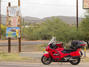
At the final turn to the "Ranch" I noticed some signage at the corner advertising the events at the local restaurant and saloon. At the top of a post, along with the usual beer ad's, and fundraisers, was a poster proclaiming in all CAPS, "MIDGET WRESTLING RETURNS". I had never heard of "midget wrestling", as either a sporting or spectator event, but alas the return date of May 15 would be well after my departure. This is probably just as well, and so I am still left unsure in the knowledge of whether I would or would not have attended the grand reopening and lost my "midget wrestling virginity".
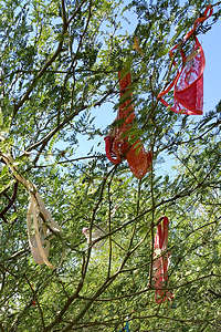
 View from SummitAfter making camp, I spent the afternoon lounging at the pool, and strolling along the paths though the scrubs and desert. Along a river wash, I came along trail that included a collection of small plastic nymphs and other whimsical characters. They were nestled among the rocks and in the branches of trees, and actually looked like a bit of outdoor art. A bit further on, and I was greeted with a tree laced with lacy womens thongs. Also, a nice artistic touch, but one that I would not have expected to find in an otherwise isolated section of the desert.
The next day, I knew that Lorry would chastise me if I did not get some real aerobic exercise. A large mountain was located directly behind my campsite, and I soon learned that there were trails to it's summit. Trail shoes on, I started out on a hike/run up the mountain.
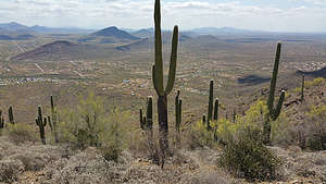
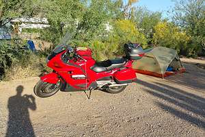
 Campsite with HondaDistances are always a challenge to judge in the desert, and this mountain was no exception. It always seemed to recede, but eventually after 2.5 miles and 1000' of elevation gain, I was on it's summit. I had run with a bottle of water, but at this point the water was long gone.
A few record photos, and I started to head back to the ranch.... or did I? From the summit, there was a maze of trails leading down, and the landscape below was homogenous enough that I didn't really know where to go? By checking the photos I had taken with the phone, I was finally able to retrace my steps, but it has been the last time that I have ever run without a gpx track being captured on my gps enabled phone or watch.
Well rested, it was with renewed enthusiasm for the road that I tidied up my gear in anticipation of the next days ride north, back to the epitome of cultured civilization, Las Vegas.
- ‹ previous
- 10 of 16
- next ›
I17 to Phoenix location map in "high definition"
Javascript is required to view this map.
