- Home
- About
- Map
- Trips
- Bringing Boat West
- Migration West
- Solo Motorcycle Ride
- Final Family XC Trip
- Colorado Rockies
- Graduates' XC Trip
- Yosemite & Nevada
- Colorado & Utah
- Best of Utah
- Southern Loop
- Pacific Northwest
- Northern Loop
- Los Angeles to NYC
- East Coast Trips
- 1 Week in Quebec
- Southeast Coast
- NH Backpacking
- Martha's Vineyard
- Canadian Maritimes
- Ocracoke Island
- Edisto Island
- First Landing '02
- Hunting Island '02
- Stowe in Winter
- Hunting Island '01
- Lake Placid
- Chesapeake
- Provincetown
- Hunting Island '00
- Acadia in Winter
- Boston Suburbs
- Niagara Falls
- First Landing '99
- Cape Hatteras
- West Coast Trips
- Maui
- Mojave 4WD Course
- Colorado River Rafting
- Bishop & Death Valley
- Kauai
- Yosemite Fall
- Utah Off-Road
- Lost Coast
- Yosemite Valley
- Arizona and New Mexico
- Pescadero & Capitola
- Bishop & Death Valley
- San Diego, Anza Borrego, Joshua Tree
- Carmel
- Death Valley in Fall
- Yosemite in the Fall
- Pacific Northwest
- Utah Off-Roading
- Southern CA Deserts
- Yosemite & Covid
- Lake Powell Covid
- Eastern Sierra & Covid
- Bishop & Death Valley
- Central & SE Oregon
- Mojave Road
- Eastern Sierra
- Trinity Alps
- Tuolumne Meadows
- Lake Powell Boating
- Eastern Sierra
- Yosemite Winter
- Hawaii
- 4WD Eastern Sierra
- 4WD Death Valley +
- Southern CA Deserts
- Christmas in Tahoe
- Yosemite & Pinnacles
- Totality
- Yosemite & Sierra
- Yosemite Christmas
- Yosemite, San Diego
- Yosemite & North CA
- Seattle to Sierra
- Southwest Deserts
- Yosemite & Sierra
- Pacific Northwest
- Yosemite & South CA
- Pacific Northwest
- Northern California
- Southern Alaska
- Vancouver Island
- International Trips
- Index
- Tips
- Books
- Photos/Videos
- Search
- Contact
Cades Cove Loop to Lebanon, TN
Thursday, April 30, 2015 - 1:15pm by Herb
262 miles and 8.75 hours from our last stop - 1 night stay
Travelogue
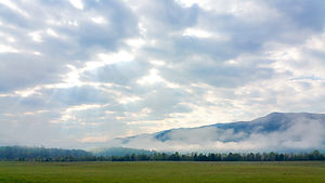
 Cades Cove MeadowSomewhat groggy from the previous nights excesses, I tried to come up with a riding plan for the day.
Many cups of coffee later my will re-materialized and I realized that I would forever regret it if I did not take a ride through Cades Cove. It was most certainly the only time in my life that I would be able ride this on my motorcycle, and probably the first or second thing that friends would ask when they learned I visited the Great Smoky Mountains National Park. So, I decided to go, even though it would involve a 4 hour detour back through the park.
Once again, timing was in my favor. While I had heard horror stories of "bumper to bumper" traffic throughout the entire loop during autumn, on this early weekday morning in April, I almost had the entire loop to myself.
The clouds hung low over the Cove, but no rain materialized. Instead, I was treated to sunbeams breaking through the clouds and illuminating the morning fog in the meadows.
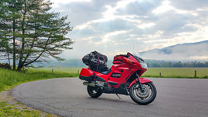
 Honda ST1100 SupermodelI posed my trusty steed in an empty parking lot, and photographed her under the soft light with sunbeams in the distance as if she were a supermodel.
A little further on the loop I strolled around the grounds of the Cable Mill Visitors Center and photographed the gristmills.
OK,, I now had to make up some time and start riding west on I40. Coming out of Gatlinburg I had to pass directly through Pigeon Forge of Dollywood Fame. The entrance to the park was enormous with parking lots as far as the eye could see. I was glad that it was off-season and that without traffic I could make good time to Knoxville. I cannot imagine what this would be like in the height of the summer tourist season.
At Knoxville, Lorry had found another Chipotle so I set that as my destination and had my second lifetime dubious Chipotle lunch.
Full of beans, I headed west on I40 and tried to make up some time.
After a while, I found an Econo Lodge in Lebanon, Tennessee that was in walking distance to a highly Yelped restaurant named Los Compadres Mexican Grill. So after another dose of Mexican food I was sated and soon asleep in my room.
- ‹ previous
- 5 of 16
- next ›
Cades Cove Loop to Lebanon location map in "high definition"
Javascript is required to view this map.
