- Home
- About
- Map
- Trips
- Bringing Boat West
- Migration West
- Solo Motorcycle Ride
- Final Family XC Trip
- Colorado Rockies
- Graduates' XC Trip
- Yosemite & Nevada
- Colorado & Utah
- Best of Utah
- Southern Loop
- Pacific Northwest
- Northern Loop
- Los Angeles to NYC
- East Coast Trips
- 1 Week in Quebec
- Southeast Coast
- NH Backpacking
- Martha's Vineyard
- Canadian Maritimes
- Ocracoke Island
- Edisto Island
- First Landing '02
- Hunting Island '02
- Stowe in Winter
- Hunting Island '01
- Lake Placid
- Chesapeake
- Provincetown
- Hunting Island '00
- Acadia in Winter
- Boston Suburbs
- Niagara Falls
- First Landing '99
- Cape Hatteras
- West Coast Trips
- Maui
- Mojave 4WD Course
- Colorado River Rafting
- Bishop & Death Valley
- Kauai
- Yosemite Fall
- Utah Off-Road
- Lost Coast
- Yosemite Valley
- Arizona and New Mexico
- Pescadero & Capitola
- Bishop & Death Valley
- San Diego, Anza Borrego, Joshua Tree
- Carmel
- Death Valley in Fall
- Yosemite in the Fall
- Pacific Northwest
- Utah Off-Roading
- Southern CA Deserts
- Yosemite & Covid
- Lake Powell Covid
- Eastern Sierra & Covid
- Bishop & Death Valley
- Central & SE Oregon
- Mojave Road
- Eastern Sierra
- Trinity Alps
- Tuolumne Meadows
- Lake Powell Boating
- Eastern Sierra
- Yosemite Winter
- Hawaii
- 4WD Eastern Sierra
- 4WD Death Valley +
- Southern CA Deserts
- Christmas in Tahoe
- Yosemite & Pinnacles
- Totality
- Yosemite & Sierra
- Yosemite Christmas
- Yosemite, San Diego
- Yosemite & North CA
- Seattle to Sierra
- Southwest Deserts
- Yosemite & Sierra
- Pacific Northwest
- Yosemite & South CA
- Pacific Northwest
- Northern California
- Southern Alaska
- Vancouver Island
- International Trips
- Index
- Tips
- Books
- Photos/Videos
- Search
- Contact
Natural Bridges National Monument, UT
Tuesday, July 19, 2005 - 9:00am by Lolo
237 miles and 5 hours from our last stop - 1 night stay
Travelogue
Natural Bridges was one of those very pleasant surprises--strikingly beautiful and completely devoid of crowds. Definitely our kind of place.
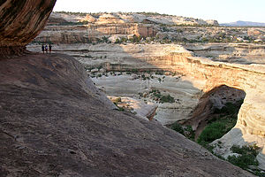 Sipapu Bridge LookoutI was a bit concerned about finding a campsite, since the guidebook indicated that the small 13-site campground in the park could only accommodate RVs under 21 feet. However, there was no problem at all. The campground was practically empty, and the sites weren't all that small. We were able to comfortably tuck our 26½-foot motorhome into one of the sites in this lovely pinyon and juniper forest.
My only regret is that we got here so late in the day. There were three spectacular bridges to explore, but we would only have time to do two of them--greatly disturbing my obsessive need to see them all. After being told to get over it, we chose two: Sipapu because it is the largest and most spectacular and Owachomo because it is the most elegant and frailest (it might not be here the next time we pass through).
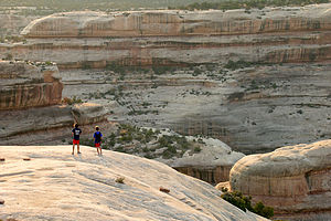 Boys on Sipapu Bridge HikeWe quickly headed out on the scenic Bridge View Drive, a 9-mile loop through the park past the trailheads for each of the bridges. Our first stop was the trailhead for Sipapu Bridge. It was so hot out that before beginning our hike we used the RV outdoor shower to soak ourselves. Feeling refreshed, we began our descent down into the canyon, which included climbing down a wooden ladder--not bad considering early visitors to the park had to use a tree. About halfway down the trail, we came out on a ledge, directly across from and slightly above, Sipapu Bridge. The view down into the canyon and across to the bridge was so incredible that we knew we had to go no further. Hiking the remaining switchbacks down to the base of the bridge was only going to use up more valuable time before sunset, and we were pretty sure that the view from the base couldn't compare with what we had right here on the ledge. We took lots of pictures.
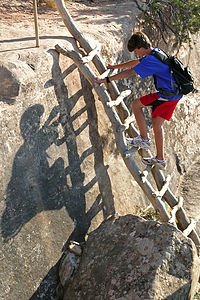 Tommy on the ladder to Sipapu BridgeThen back up the ladders, into the RV, and on to the next trailhead. It killed me as we zipped past the one for Kachina Bridge, but there just wasn't time. The sun was already getting pretty low. The hike to Owachomo was much shorter and easier, so we were at its base in no time. This was a much different perspective than the view we had of Sipapu--up close and underneath looking up at it. The bridge really is quite frail--erosion has worn it down to a width of only 9 feet. The lighting was going fast, so we quickly took some photos. Tommy spent most of his time stalking a lizard with his camera, and he did manage to get some pretty good close-ups. Thank god for digital--he must have taken over 20 shots.
Once back at the RV, Andrew began complaining about a painful burning sensation in his foot. Having definite hypochondriac tendencies, he became convinced that a scorpion had bit him and that death was imminent. Knowing his son all too well, Herb calmly took off Andrew's sneaker and removed the cactus burrs that were clinging to his sock.
We got back to the campground just as it was getting dark. Parked in the campsite right across from us was another Lazy Daze motorhome, just like ours. It might not sound like a big deal, but they are somewhat rare so the fact that 2 out of the 5 families in this campground had Lazy Dazes was pretty exciting for us. Maybe exciting is too strong a word, but it did get our attention.
Description
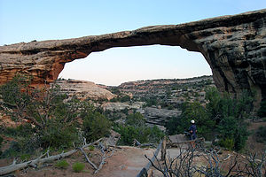 Owachomo BridgeNatural Bridges National Monument in southeastern Utah is part of the Great Basin Desert of the Colorado Plateau. Its elevation ranges from 5,500 feet in the bottom of the canyon to 6,500 feet on top of the pinyon and juniper covered mesa. The most prominent and best-known features of the park are its three large natural bridges--Sipapu, Kachina, and Owachomo. Sipapu and Kachina are the second and third largest natural bridges in the world.
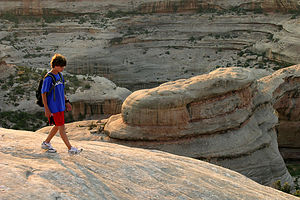 Tommy on Sipapu Bridge HikeThe bridges were formed millions of years ago by the action of the streams that flowed through the canyon. These streams, which flowed in wide meandering loops, eventually broke through the rock fins separating its loops. The streams then shifted directions and took a short cut through what became a natural bridge. Natural bridges look a lot like arches, but they are different in the way they are formed. Natural bridges are carved out of rock by flowing water, while arches are formed by frost and seeping water erosion.
Each of the three bridges in the park illustrates a different stage of bridge development:
- Owachomo is the oldest bridge and, therefore, the most slender and frail. It is also the most elegant. It spans 180 feet and is 106 feet high, but the forces of erosion have worn its bridge to a thickness of only 9 feet.
- Sipapu Bridge is the largest and most spectacular of the three bridges. It has a span of 268 feet and a height of 220 feet, large enough to fit the dome of the Capitol building. In the life span of a bridge, it is considered middle-aged. It's bridge has had less time to erode and is 53 feet thick.
- Kachina is the youngest of the bridges. It is much thicker (93 feet) and has the smallest opening of the three. Its opening would be even smaller, but in 1992, 4,000 tons of sandstone fell from its opening enlarging it substantially.
All three of bridges will continue to erode and widen, eventually causing them to collapse under their own weight.
The best way to see the park is the 9-mile Bridge View Drive, which leads to overlooks and trailheads for each of the three natural bridges. Round trip mileages for the three hikes are:
- Sipapu - 1.2 miles with a 500 foot elevation change - allow 1 hour.
- Kachina - 1.5 miles with a 400 foot elevation change - allow 1 ¼ hours.
- Owachomo - 0.6 miles with a 180 foot elevation change - allow ½ hours
There is a small 13-site campground in the park about .3 miles past the Visitor Center that operates on a first-come, first-served basis. There is no water or hookups.
- ‹ previous
- 8 of 23
- next ›
Natural Bridges National Monument location map in "high definition"
Javascript is required to view this map.
