- Home
- About
- Map
- Trips
- Bringing Boat West
- Migration West
- Solo Motorcycle Ride
- Final Family XC Trip
- Colorado Rockies
- Graduates' XC Trip
- Yosemite & Nevada
- Colorado & Utah
- Best of Utah
- Southern Loop
- Pacific Northwest
- Northern Loop
- Los Angeles to NYC
- East Coast Trips
- 1 Week in Quebec
- Southeast Coast
- NH Backpacking
- Martha's Vineyard
- Canadian Maritimes
- Ocracoke Island
- Edisto Island
- First Landing '02
- Hunting Island '02
- Stowe in Winter
- Hunting Island '01
- Lake Placid
- Chesapeake
- Provincetown
- Hunting Island '00
- Acadia in Winter
- Boston Suburbs
- Niagara Falls
- First Landing '99
- Cape Hatteras
- West Coast Trips
- Maui
- Mojave 4WD Course
- Colorado River Rafting
- Bishop & Death Valley
- Kauai
- Yosemite Fall
- Utah Off-Road
- Lost Coast
- Yosemite Valley
- Arizona and New Mexico
- Pescadero & Capitola
- Bishop & Death Valley
- San Diego, Anza Borrego, Joshua Tree
- Carmel
- Death Valley in Fall
- Yosemite in the Fall
- Pacific Northwest
- Utah Off-Roading
- Southern CA Deserts
- Yosemite & Covid
- Lake Powell Covid
- Eastern Sierra & Covid
- Bishop & Death Valley
- Central & SE Oregon
- Mojave Road
- Eastern Sierra
- Trinity Alps
- Tuolumne Meadows
- Lake Powell Boating
- Eastern Sierra
- Yosemite Winter
- Hawaii
- 4WD Eastern Sierra
- 4WD Death Valley +
- Southern CA Deserts
- Christmas in Tahoe
- Yosemite & Pinnacles
- Totality
- Yosemite & Sierra
- Yosemite Christmas
- Yosemite, San Diego
- Yosemite & North CA
- Seattle to Sierra
- Southwest Deserts
- Yosemite & Sierra
- Pacific Northwest
- Yosemite & South CA
- Pacific Northwest
- Northern California
- Southern Alaska
- Vancouver Island
- International Trips
- Index
- Tips
- Books
- Photos/Videos
- Search
- Contact
Horseshoe Canyon and the Great Gallery (Canyonlands National Park), UT
Saturday, May 15, 2021 - 11:00am by Lolo
140 miles and 3 hours from our last stop - 1 night stay
Travelogue
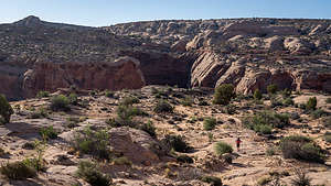 Hike down into Horseshoe Canyon to the Grand GalleryAfter completing three phenomenal days driving the White Rim Trail in Canyonlands, we started heading towards our next destination - the Great Gallery in Horseshoe Canyon, a detached section of Canyonlands National Park, and the site of the single greatest display of prehistoric rock art in North America, dating back to the Fremont period around 1000 BC.
When we reached the town of Green River, we stopped for lunch at Ray’s Tavern, which was pretty hopping with locals, which is usually a good sign. The Burgers and fries were good, but I have now learned to never order coffee in a tavern for lunch. I think I was probably the only one that had ordered a cup in hours - and the coffee tasted like it. Otherwise, the meal was fine, and it was good to be back, if only for a short while, in civilization again.
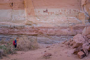 Horseshoe GalleryAfter leaving Green River, we headed south on Utah 24 to a turnoff on the left about a ½ mile south of Goblin Valley State Park. From there we drove on a dirt road for 25 miles to a roofed signpost with a junction, where we bore left for another 5 miles. We then turned right and drove another 2 miles to a parking lot and a primitive campground near the top of the mesa.
There were a few cars scattered about, some day hikers and some campers. We chose a good spot at the edge of the mesa looking out at the colorful Horseshoe Canyon below.
The next morning we set off on our hike to the Great Gallery. The air was delightfully cool as we wandered along rock ledges and sand about a mile and a half down to the canyon floor. From there we continued walking up the sandy canyon, surrounded on both sides by red Navajo sandstone cliffs.
About 2 miles into the hike, we took a short spur trail on the left to the High Gallery, the first of four walls with pictographs. This particular panel had several human figures and handprints.
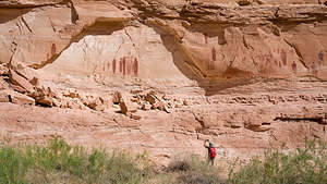 Lolo approaches the Great GalleryA few minutes further, we came to a right spur trail, which led us to the Horseshoe Shelter pictograph panel, which had more drawings, including several ghost-like figures.
At 2.5 miles, we reached the Alcove Galley, which we had some difficulty finding at first. Finally we found the rather faint on the right wall, at the base of the alcove.
A little over a mile later, (out 3.7 miles from the trailhead), we arrived at the crown jewel of Horseshoe Canyon - the Great Gallery, a large and well-preserved panel of intricately beautiful human and animal figures, about 15 feet above us, stretching over 120 feet along the smooth slickrock wall. There were over 75 pictographs in shades of dark red, brown, and white.
They were painted somewhere between 2,000 and 8,000 years ago (there is still a controversy as to their age) by Desert Archaic Indians that are the ancestors of the Ancestral Puebloans.
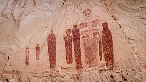 The Holy Ghost on the Great GalleryMost of the pictographs were life-size, ghostlike figures with large tapered torsos, and no arms or legs. They appeared weightless and floating.
My personal favorite was a 7-foot tall figure, with huge, round, empty eye sockets, known as the Holy Ghost. Like the six smaller figures around him, he too had no arms or legs. His great size definitely seemed to define him as an important figure.
Although the meanings of these drawings will never be definitively known, one theory is that the figures are depictions of shamans (religious or mystical leaders) in drug-induced spiritual states on a spiritual journey of transformation from the human world to the realm of the spirit.
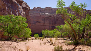 The hike out of Horseshoe CanyonIt was a spiritual experience just gazing up at them, enhanced by having to work to get to them, hiking through what was once their home.
The hike out was much hotter and since this was a hike down into a canyon, the return was mostly up. All in all, the hike was about 7.5 miles with a 1,330-foot elevation gain - but very well worth it!
After leaving Horseshoe Canyon, we drove to the small town of Hanksville where we stopped to have lunch at Duke’s Slickrock Grill. We were really getting into this midday big meal thing.
From there we continued on to Capitol Reef National Park where to do the Cathedral Valley Loop.
- ‹ previous
- 4 of 8
- next ›
Horseshoe Canyon and the Great Gallery (Canyonlands National Park) location map in "high definition"
Javascript is required to view this map.
