- Home
- About
- Map
- Trips
- Bringing Boat West
- Migration West
- Solo Motorcycle Ride
- Final Family XC Trip
- Colorado Rockies
- Graduates' XC Trip
- Yosemite & Nevada
- Colorado & Utah
- Best of Utah
- Southern Loop
- Pacific Northwest
- Northern Loop
- Los Angeles to NYC
- East Coast Trips
- 1 Week in Quebec
- Southeast Coast
- NH Backpacking
- Martha's Vineyard
- Canadian Maritimes
- Ocracoke Island
- Edisto Island
- First Landing '02
- Hunting Island '02
- Stowe in Winter
- Hunting Island '01
- Lake Placid
- Chesapeake
- Provincetown
- Hunting Island '00
- Acadia in Winter
- Boston Suburbs
- Niagara Falls
- First Landing '99
- Cape Hatteras
- West Coast Trips
- Maui
- Mojave 4WD Course
- Colorado River Rafting
- Bishop & Death Valley
- Kauai
- Yosemite Fall
- Utah Off-Road
- Lost Coast
- Yosemite Valley
- Arizona and New Mexico
- Pescadero & Capitola
- Bishop & Death Valley
- San Diego, Anza Borrego, Joshua Tree
- Carmel
- Death Valley in Fall
- Yosemite in the Fall
- Pacific Northwest
- Utah Off-Roading
- Southern CA Deserts
- Yosemite & Covid
- Lake Powell Covid
- Eastern Sierra & Covid
- Bishop & Death Valley
- Central & SE Oregon
- Mojave Road
- Eastern Sierra
- Trinity Alps
- Tuolumne Meadows
- Lake Powell Boating
- Eastern Sierra
- Yosemite Winter
- Hawaii
- 4WD Eastern Sierra
- 4WD Death Valley +
- Southern CA Deserts
- Christmas in Tahoe
- Yosemite & Pinnacles
- Totality
- Yosemite & Sierra
- Yosemite Christmas
- Yosemite, San Diego
- Yosemite & North CA
- Seattle to Sierra
- Southwest Deserts
- Yosemite & Sierra
- Pacific Northwest
- Yosemite & South CA
- Pacific Northwest
- Northern California
- Southern Alaska
- Vancouver Island
- International Trips
- Index
- Tips
- Books
- Photos/Videos
- Search
- Contact
Cathedral Valley Loop (Capitol Reef National Park), UT
Sunday, May 16, 2021 - 7:00pm by Lolo
140 miles and 5 hours from our last stop - 1 night stay
Travelogue
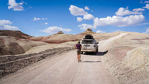 Along the Cathedral Valley LoopWhile browsing through my go-to book of beautiful places in southern Utah (“Photographing the Southwest”), I came across an area in Capitol Reef National Park that I had never heard of before: the Cathedral Valley. Perhaps that's because it’s a 4WD road, and the last time we were in Utah in 2005, we were traveling in a motorhome.
The CV Loop requires a 4WD high clearance vehicle, and it is recommended to drive the loop clockwise, so that you get the Fremont River crossing over with first to make sure it is feasible.
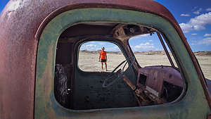 Remnants of a human presence in Cathedral ValleyAs suggested, we stopped at the Capitol Reef Visitor Center to ask about road conditions, river height, and to purchase the “Self-Guided auto-tour of Cathedral Valley.”
Once that was accomplished, we headed back east along Utah 24 for 11.7 miles to Mile Post 91, to the place where we would have to cross the Fremont River. The river looked pretty shallow, but we got out and walked it anyway to make sure. I walked to the other side of the river and filmed Herb drive the recommended 100 feet along the right shoreline and then across. Piece of cake!
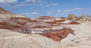 Bentonite HillsOnce across the river, we continued on Hartnet Road as it climbed past the colorful hills of the Waterpocket Fold. 200 million years ago, this area consisted of flat layers of sediment formed at near sea level. Then about 50 to 70 million years ago, tectonic forces uplifted them, forming a 90-mile massive wrinkle in the Earth’s crust, now known as the Waterpocket Fold, North America’s largest monocline.
We hadn’t had a shower in 3 days, so we drove up a wash for a mile or so, set up our helio shower, and washed 3 days of dust and dirt off of us. Now that we were clean and presentable, we continued on
 Lower South Desert OverlookAt about 6 miles into our drive, we came upon an old truck that was once used to drill a well to provide water for their cattle. It would be the only man-made object we would see along the entire drive - except for the pit toilet in the campground.
At about 9 miles from the river ford, we entered the beautiful, multi-colored Bentonite Hills, a series of rounded mounds with bands of brown, red, purple, gray, and green. Fortunately, today was a beautiful sunny day, because when it rains, the Bentonite clay absorbs the water and becomes very slick, making it very difficult to drive on.
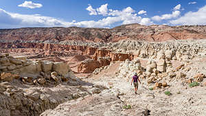
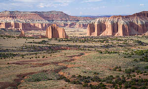 Upper Cathedral Valley14 miles from River Ford, a side road leads to the Lower South Desert Overlook, where a short walk brought us to a scenic view of the lower South Desert, a large valley that runs parallel to the Waterpocket Fold.
The whole time we were driving, we kept thinking about where we might want to camp for the night. Within the bounds of Capitol Reef National Park, camping is restricted to the one first-come, first-served primitive campground near Upper Cathedral Valley, which has only 6 campsites. We had no idea if anything would be available when we arrived there later this afternoon.
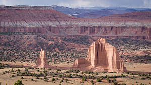 Upper Cathedral ValleyOur other, and Herb’s much preferred, choice was camping on BLM land that borders the park. For now, we just continued on our way. At about 29 miles from River Ford we had a decision to make. Should we continue straight which would bring us out of the park and into the Fishlake National Forest, where we could camp, or should we turn right and try our luck at the Cathedral Valley Campground.
We decided to try our luck, because we knew that there was other BLM land further on, if the campground was full. Well, the campground was definitely full, and a gentleman in the last campsite told us that we were the 7th car in the last half hour unsuccessfully looking for a site.
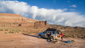 Our BLM campsite just outside the ParkThe photographer who wrote the book where I first discovered the Cathedral Valley Loop, said that he had never seen another soul in the campground. Well, he must not have been traveling post Covid vaccinations, because everyone and their uncle had now discovered the beauty of spending time in the great outdoors.
In our futile attempt to get a campsite, we had passed the turnoff for the spur road to the Upper Cathedral Valley overlook, which was supposed to be one of the highlights of the drive, so we drove back the short distance and walked out to the edge of the plateau. All I can say is “Wow!” The view of the monoliths and high walls of the Upper Cathedral Valley below us were breathtaking.
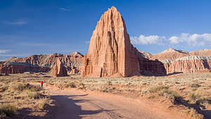 Temples of the Sun and MoonIt was getting late, so the lighting was good, but that also meant we had to find a place to camp soon. We were pretty tired - hard to believe that we had done the 7.5-mile hike to the Great Gallery just that morning. I checked the map and saw that it would be another 13 miles or so before we left the park boundary and entered BLM land again.
We skipped the turnoff for the Gypsum Sinkhole, which would have been interesting, but it was close to getting dark. We wanted to get as close as possible to the turnoff for the Temples of the Sun and Moon in Lower Cathedral Valley, so we could get there early tomorrow to catch the morning light. We found a pretty decent spot about 2 miles shy of that to stop for the night.
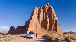 Temple of the SunFortunately, we had had a big lunch at Duke’s Slickrock Grill, which felt like a week ago, so we just made sandwiches for dinner.
The next morning we arose early to drive the two or three miles to the turnoff for the spur road to the Temples of the Sun and Moon, Cathedral Valley’s most impressive monoliths. As we approached, we could have kicked ourselves, as we came across what was an obvious BLM campsite, right at the edge of the national park boundary, very near to the two temples. I think someone had camped there though, because when we pulled into the parking lot, there were two photographers with tripods already leaving. We had just missed the best light of sunrise. We really have to learn to get an earlier start in the morning. We do sunsets much better than sunrises.
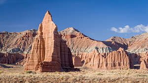 Temple of the MoonHowever, it was still pretty phenomenal. We first pulled into the turnout for Glass Mountain from which you can take a photograph with both monoliths in it. After that we drove down to their base level where we could get up to them close and personal. They are huge. The Temple of the Sun rises 422 feet and the Temple of the Moon 265 feet from the valley floor.
Unlike the monoliths we saw in the Upper Cathedral Valley, these have lost their protective gray caps of Curtis Formation sandstone. This means that they are eroding pretty rapidly, in geological terms anyway. Up close, the face of them looks a bit like flowing mud. That’s because in some way, it actually is. When there is a heavy enough rainstorm, the surface actually turns into mud and oozes down, hardening again when things dry.
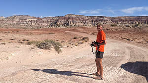 Near the end of the Cathedral Valley LoopAlthough the two Temples are the highlights of the drive, there were still plenty more beautiful rock formations as we continued along. I wish I understood geology better to understand how these beautiful mounds of white, bluish gray, and red bands had formed.
Soon enough we were back to the asphalt of Utah 24. Since we would be heading next to the Burr Trail with no grocery store along the way, we drove back to the Visitor Center to fill up our water jugs to get us through the next few days.
- ‹ previous
- 5 of 8
- next ›
Cathedral Valley Loop (Capitol Reef National Park) location map in "high definition"
Javascript is required to view this map.
