- Home
- About
- Map
- Trips
- Bringing Boat West
- Migration West
- Solo Motorcycle Ride
- Final Family XC Trip
- Colorado Rockies
- Graduates' XC Trip
- Yosemite & Nevada
- Colorado & Utah
- Best of Utah
- Southern Loop
- Pacific Northwest
- Northern Loop
- Los Angeles to NYC
- East Coast Trips
- 1 Week in Quebec
- Southeast Coast
- NH Backpacking
- Martha's Vineyard
- Canadian Maritimes
- Ocracoke Island
- Edisto Island
- First Landing '02
- Hunting Island '02
- Stowe in Winter
- Hunting Island '01
- Lake Placid
- Chesapeake
- Provincetown
- Hunting Island '00
- Acadia in Winter
- Boston Suburbs
- Niagara Falls
- First Landing '99
- Cape Hatteras
- West Coast Trips
- Maui
- Mojave 4WD Course
- Colorado River Rafting
- Bishop & Death Valley
- Kauai
- Yosemite Fall
- Utah Off-Road
- Lost Coast
- Yosemite Valley
- Arizona and New Mexico
- Pescadero & Capitola
- Bishop & Death Valley
- San Diego, Anza Borrego, Joshua Tree
- Carmel
- Death Valley in Fall
- Yosemite in the Fall
- Pacific Northwest
- Utah Off-Roading
- Southern CA Deserts
- Yosemite & Covid
- Lake Powell Covid
- Eastern Sierra & Covid
- Bishop & Death Valley
- Central & SE Oregon
- Mojave Road
- Eastern Sierra
- Trinity Alps
- Tuolumne Meadows
- Lake Powell Boating
- Eastern Sierra
- Yosemite Winter
- Hawaii
- 4WD Eastern Sierra
- 4WD Death Valley +
- Southern CA Deserts
- Christmas in Tahoe
- Yosemite & Pinnacles
- Totality
- Yosemite & Sierra
- Yosemite Christmas
- Yosemite, San Diego
- Yosemite & North CA
- Seattle to Sierra
- Southwest Deserts
- Yosemite & Sierra
- Pacific Northwest
- Yosemite & South CA
- Pacific Northwest
- Northern California
- Southern Alaska
- Vancouver Island
- International Trips
- Index
- Tips
- Books
- Photos/Videos
- Search
- Contact
Great Basin National Park, NV
Sunday, September 10, 2023 - 11:15am by Lolo
156 miles and 3 hours from our last stop
Travelogue
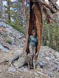
 Reverse tree huggerAfter spending a short time photographing the Eureka Main Street, we continued east on “The Loneliest Road,” eventually passing through the town of Ely, Nevada (mile 320). With a population of 4,002, it was significantly larger than Eureka.
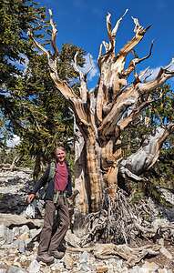
 Bristlecone PineEly is the site of Nevada’s largest and longest-lived mining ventures, but they mined for copper, not silver or gold. At its peak during the 1950s, Ely produced over a billion dollars worth of copper ore and employed over 10,000 people. After the mines closed down in 1982, the town went bust and the railroad depot was turned into the Nevada Northern Railway Museum. However, it is still one of the larger towns on the Loneliest Road and home to the only supermarket in 250 miles.
East of Ely, US-50 continues another 25 miles before ascending 7,722-foot Connors Pass. From the summit, 13,061-foot Wheeler Peak comes into view.
In another 20 miles is the town of Baker and the turnoff for Great Basin National Park, Nevada’s only national park. It’s also one of the smallest parks in the national park system, and its remote location near the Nevada-Utah border also makes it one of the least visited.
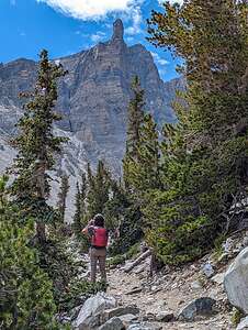
 Wheeler Peak comes into viewWe were now 382 miles from Reno, almost done with the 400 miles through Nevada on the Loneliest Road.
Despite Great Basin’s small size, it boasts a treasure trove of riches, including:
- the only glacier in Nevada
- 13,063-foot Wheeler Peak, the second highest mountain in the state
- a large forest of 3,000- to 4,000-year-old bristle-cone pines, the oldest living creatures on the planet
- groves of white-barked aspen
- the extensive and fascinating Lehman Caves.
The last time we were here back in 2007, we only visited the Lehman Caves, because we were not allowed to drive up to Wheeler Peak in our Lazy Daze motorhome, (no vehicles over 20 feet allowed). The Wheeler Peak Road is about 12 miles one way and climbs 3,400 feet in elevation as it winds its way up the Snake Mountain Range. Not appropriate for a motorhome.
.thumbnail.jpg) Rock GlacierIt was, however, very appropriate for our Toyota 4Runner, so up we went to Wheeler Peak, where we would start our Bristlecone and Glacier hike. Pretty cool that in one hike we would be able to walk amongst the oldest living species on Earth, and see Nevada’s only remaining glacier (before it melts away).
Rock GlacierIt was, however, very appropriate for our Toyota 4Runner, so up we went to Wheeler Peak, where we would start our Bristlecone and Glacier hike. Pretty cool that in one hike we would be able to walk amongst the oldest living species on Earth, and see Nevada’s only remaining glacier (before it melts away).
We headed out on the Bristlecone Glacier trail and in about a mile came to a grove of Bristlecone Pines, which are the world’s oldest living species, the longest having lived almost 5,000 years.
They are very photogenic, each of them individually sculpted by thousands of years of wind, ice, and extreme exposure to the elements. Their twisted and contorted shapes are evidence of their ability to not only survive, but to thrive in adverse living conditions. It’s funny how the harshest growing conditions produce trees that live the longest and are the most contorted and interesting. There’s much to be said for tough love.
.thumbnail.jpg) Out on the iceOne thing I did not though was that the bristlecones here looked much less healthy than the ones we had recently visited in the Ancient Bristlecone Pine Forest in Big Pine, California. Many of the ones in Great Basin were dead - you can tell by the fact that they are gray rather than having that rich brownish chocolate coloring. Not sure why that might be. Maybe it has something to do with climate change and the differing attitudes and environments of the different groves.
Out on the iceOne thing I did not though was that the bristlecones here looked much less healthy than the ones we had recently visited in the Ancient Bristlecone Pine Forest in Big Pine, California. Many of the ones in Great Basin were dead - you can tell by the fact that they are gray rather than having that rich brownish chocolate coloring. Not sure why that might be. Maybe it has something to do with climate change and the differing attitudes and environments of the different groves.
Once past the Bristlecone Pine Grove, the woods became more sparse and we got our first clear views of Wheeler Peak Glacier, which sits at the base of Wheeler Peak, in a protected cirque around 11,500 feet in elevation.
As we proceeded up onto the glacier moraine, the trail became much rockier and unstable, as we transitioned into alpine territory.
.thumbnail.jpg) Out on the iceUnlike the ice glaciers we had seen on our recent trip to Iceland, the Wheeler Peak Glacier is a rock glacier, meaning that the ice visible on the surface is only a portion of the whole glacier, the rest is covered with debris and therefore considered to be a rock glacier.
Out on the iceUnlike the ice glaciers we had seen on our recent trip to Iceland, the Wheeler Peak Glacier is a rock glacier, meaning that the ice visible on the surface is only a portion of the whole glacier, the rest is covered with debris and therefore considered to be a rock glacier.
The glacier itself isn’t all that impressive, as it is shrinking due to climate change, but the surrounding cirque and towering peaks were beautiful.
When we got to the foot of the glacier, of course, we couldn’t resist walking out on it.
With the exception of the altitude (over 10,200 feet ), it was not a difficult hike - just 4.5 miles with a little over 1,000 foot elevation gain
- ‹ previous
- 2 of 16
- next ›
Great Basin National Park location map in "high definition"
Javascript is required to view this map.
