- Home
- About
- Map
- Trips
- Bringing Boat West
- Migration West
- Solo Motorcycle Ride
- Final Family XC Trip
- Colorado Rockies
- Graduates' XC Trip
- Yosemite & Nevada
- Colorado & Utah
- Best of Utah
- Southern Loop
- Pacific Northwest
- Northern Loop
- Los Angeles to NYC
- East Coast Trips
- 1 Week in Quebec
- Southeast Coast
- NH Backpacking
- Martha's Vineyard
- Canadian Maritimes
- Ocracoke Island
- Edisto Island
- First Landing '02
- Hunting Island '02
- Stowe in Winter
- Hunting Island '01
- Lake Placid
- Chesapeake
- Provincetown
- Hunting Island '00
- Acadia in Winter
- Boston Suburbs
- Niagara Falls
- First Landing '99
- Cape Hatteras
- West Coast Trips
- Maui
- Mojave 4WD Course
- Colorado River Rafting
- Bishop & Death Valley
- Kauai
- Yosemite Fall
- Utah Off-Road
- Lost Coast
- Yosemite Valley
- Arizona and New Mexico
- Pescadero & Capitola
- Bishop & Death Valley
- San Diego, Anza Borrego, Joshua Tree
- Carmel
- Death Valley in Fall
- Yosemite in the Fall
- Pacific Northwest
- Utah Off-Roading
- Southern CA Deserts
- Yosemite & Covid
- Lake Powell Covid
- Eastern Sierra & Covid
- Bishop & Death Valley
- Central & SE Oregon
- Mojave Road
- Eastern Sierra
- Trinity Alps
- Tuolumne Meadows
- Lake Powell Boating
- Eastern Sierra
- Yosemite Winter
- Hawaii
- 4WD Eastern Sierra
- 4WD Death Valley +
- Southern CA Deserts
- Christmas in Tahoe
- Yosemite & Pinnacles
- Totality
- Yosemite & Sierra
- Yosemite Christmas
- Yosemite, San Diego
- Yosemite & North CA
- Seattle to Sierra
- Southwest Deserts
- Yosemite & Sierra
- Pacific Northwest
- Yosemite & South CA
- Pacific Northwest
- Northern California
- Southern Alaska
- Vancouver Island
- International Trips
- Index
- Tips
- Books
- Photos/Videos
- Search
- Contact
Crater Lake National Park, OR
Tuesday, August 15, 2017 - 8:30am by Lolo
291 miles and 6 hours from our last stop - 2 night stay
Travelogue
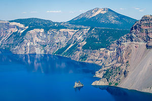 Crater Lake's Phantom ShipAs we approached Crater Lake, the smoke from the nearby wildfires was getting worse and worse. Hopefully, we would have some views on our hike tomorrow.
When we got to Mazama, we found that all the first-come-first-serve sites were taken and the campground was totally full. Thank goodness we had a reservation. Checking in was rather a unique process. Rather than telling you what our site number, we were told to just look for an unoccupied site with a yellow slash on the post - they promised us there was one left.
It felt a bit like an Easter Egg hunt as we drove through each of the five campground loops to find it. Sure enough, it was at the end of the very last loop we checked. I was getting worried for awhile there.
Later that evening I took a walk to scout out a better site to move to in the morning - one closer to the rim of Annie Creek Canyon. I checked the departure dates on all the sites with a yellow bar and found a good one that would free up in the morning.
Early the next morning we moved into our much more spacious campsite right alongside the Annie Creek Trail.
 Along the Annie's Creek TrailI am always a bit more antsy then Herb, so while he read his book, I set out on the trail along the rim to the right to hike the 1.7-mile loop trail down into and back up out of the canyon. Unfortunately, I only got about ½ a mile, and had just started descending into the canyon, before encountering a trail closed sign. On my way back to the campsite, I ran into a few people carrying spades and shovels and asked them about the trail. They said that a bridge across the creek was out, but I could get down to the canyon by doing the loop in the opposite direction.
So back I went along the rim of the canyon past our campsite, waving to Herb, until I found the turnoff for the other half of the trail that descended about 200 feet down into the canyon. I followed a series of steep switchbacks that led down to lovely Annie’s Creek. From there, the trail followed the creek, crossing a couple of bridges that fortunately were intact. The wildflowers alongside the trail were beautiful. Eventually, after about a mile I did come to the washed out bridge and had to turn around and retrace my steps back up to the rim.
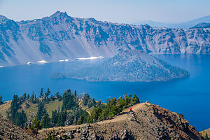 Wizard Island from Garfield PeakThe Annie’s Creek hike was just a surprise bonus, because our real plan for the day was to hike from the Crater Lake Lodge in Rim Village to Garfield Peak, a 3.8-mile, relatively strenuous, out-and-back hike to tremendous views of Crater Lake and the surrounding mountains.
After leaving the Crater Lake Lodge parking lot, we hiked up the steep trail for about a half mile, where we got our first views down of the lake. From there we continued eastward along a ridge, continuing to climb upwards for close to another mile and a half before arriving at the 8,060-foot summit where the views of the lake and the Phantom Ship were even better.
While enjoying the views at the top, my phone rang, which was surprising, considering Crater Lake National Park supposedly has no cell coverage whatsoever. I guess they let important news through, because it was Andrew calling to tell us that he got a really good job offer. I’m so glad we were able to get his call and share in the excitement.
The way back was downhill all the way.
Description
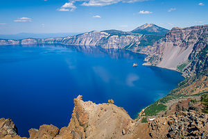 View from summit of Garfield PeakCrater Lake is the only national park that is located within a dormant volcano. More than 7,500 years ago, Mount Mazama erupted, spewing out so much pumice and ash that the summit collapsed, creating a giant caldera, measuring 4,000 feet deep and 6 miles across. A series of smaller eruptions afterwards formed several cinder cones on the caldera floor, the largest of which is 2,700-foot high Wizard Island.
Over the next 700 years or so, rain and snowmelt filled the caldera creating what is now the deepest lake in the United States. It is 1,943 feet deep at its deepest point.
Wizard Island is the only cinder cone tall enough to be exposed, rising 755 feet above the current lake level. The top of the Wizard Island cone is capped by a crater about 100 feet deep and 500 feet wide. In fact, this is the only crater in Crater Lake National Park. The lake itself should more accurately be named Caldera Lake.
It is Crater Lake’s extreme depth and purity that gives it its clarity and magnificent deep blue color. As sunlight penetrates the lake, the water molecules absorb the longer red waves in the spectrum and reflect the shorter violet and blue waves, giving its intense deep blue hue.
Crater Lake has no streams flowing into or out of it. It is refilled entirely from rain and snowmelt and is lost through evaporation and subsurface seepage. As a result, the lake had no fish in it until rainbow trout and kokanee salmon were introduced by humans from 1888 to 1941.
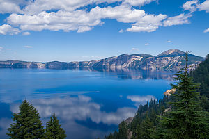 Views from Garfield Peak TrailIf you only have a day to visit the park, the best way to see it is to drive the 33-mile Rim Drive, which encircles the entire lake, stopping at its many overlooks. Because of heavy snowfalls, the Drive is generally open from July to October, and partially open in May, June, and November.
A good place to start the drive is at the Rim Village Visitor Center at the southern end of the lake, where you can stroll out to the Sinnott Memorial Overlook for a spectacular view of the lake and Wizard Island.
The best way to do the Rim Drive is clockwise, so that you can most easily pull into the scenic viewpoints on the lake side of the road. There are 25 of them, so it is very easy to spend a half-day enjoying the drive. My favorites are the overlook at mile 4, which offers an excellent view of Wizard Island, rising 755 above the lake’s surface, and the Phantom Rock Overlook at mile 23.2.
If you have more time, a boat trip out on the lake is definitely worthwhile. Tours are offered from late July to mid-September and in 2013. There are two types of cruises offered. The Standard Tour leaves 6 times a day and costs $35 for an adult. It does not stop at Wizard Island. The Wizard Island Tour only leaves twice a day (9:30 and 12:30) and costs $45 for an adult. This tour drops people off and allows them to hike and explore the island for 3 hours before the boat returns to bring you back. Each tour has a park ranger aboard to discuss the geology and natural history of Crater Lake. Tickets sell out quickly, so be sure to buy them in advance at the kiosk in the Crater Lake Lodge. I definitely recommend the Wizard Lake Tour.
To get to the boat, park at the Cleetwood Cove Trailhead on the north side of the lake, and hike the steep 1 mile trail down to the lakeshore. This trail provides the only access to the lake. Before committing to the trek down, make sure you feel comfortable with the strenuous climb back up.
Once you reach the lakeshore, you are sure to see dozens of people jumping from a high rock into the chilly waters of the lake.
Once on Wizard Island, there are two hiking options. The most popular is the relatively steep 0.9 mile trek (each way) up the steep Wizard Island Summit Trail. Besides the wonderful views of the lake along the way, once on top of the cinder cone, you can descend into 100-feet deep crater.
The other option is to hike along the rough volcanic rock along the shore to Fumarole Bay – about 0.7 miles each way. There is an excellent view from here of Watchman Peak, straight across the lake. The shallow, clear water in the bay is good for swimming (chilly) and fishing for rainbow trout and kokanee salmon. Unlicensed fishing is allowed in the park without any limitation of size, species, or number. In fact, the park encourages fishing to try to rid the lake of these non-indigenous fish.
In addition to the Cleetwood Cove and Wizard Island trails, there are several other hiking options in the park. These include:
- 3.5 mile (round trip) steep hike to Garfield Peak, with tremendous views after ½ mile of hiking. The trail starts from the parking lot of Crater Lake Lodge
- 1.7 mile (round trip) Annie Creek Canyon Trail, which begins behind the amphitheater at the Mazama Campground and loops down to the bottom of a deep, stream-cut canyon and back.
- 3.9 mile (round trip) hike to the summit of Mt. Scott, the highest point in the park, with panoramic views of the lake and Klamatch Basin.
- 0.7 mile (round trip) Pinnacles hike through dramatic tall pinnacles and spires. The trailhead is located on the Pinnacles Spur Road, 7 miles southeast of the Phantom Ship Overlook in the southeast corner of the park.
The park has two campgrounds:
- The Lost Creek campground is tent only and is open from mid-July to late September. This campground is located on the Pinnacles Spur Road in the southeast corner of the park.
- The Mazama Campground has 213 tent and RV sites (and some hookups) and is open from late June to mid October. This campground is located in Mazama Village, about 3 miles south of the Steel Visitor Center
- ‹ previous
- 3 of 6
- next ›
Crater Lake National Park location map in "high definition"
Javascript is required to view this map.
