- Home
- About
- Map
- Trips
- Bringing Boat West
- Migration West
- Solo Motorcycle Ride
- Final Family XC Trip
- Colorado Rockies
- Graduates' XC Trip
- Yosemite & Nevada
- Colorado & Utah
- Best of Utah
- Southern Loop
- Pacific Northwest
- Northern Loop
- Los Angeles to NYC
- East Coast Trips
- Martha's Vineyard
- 1 Week in Quebec
- Southeast Coast
- NH Backpacking
- Martha's Vineyard
- Canadian Maritimes
- Ocracoke Island
- Edisto Island
- First Landing '02
- Hunting Island '02
- Stowe in Winter
- Hunting Island '01
- Lake Placid
- Chesapeake
- Provincetown
- Hunting Island '00
- Acadia in Winter
- Boston Suburbs
- Niagara Falls
- First Landing '99
- Cape Hatteras
- West Coast Trips
- Burning Man
- Utah Off-Roading
- Maui
- Mojave 4WD Course
- Colorado River Rafting
- Bishop & Death Valley
- Kauai
- Yosemite Fall
- Utah Off-Road
- Lost Coast
- Yosemite Valley
- Arizona and New Mexico
- Pescadero & Capitola
- Bishop & Death Valley
- San Diego, Anza Borrego, Joshua Tree
- Carmel
- Death Valley in Fall
- Yosemite in the Fall
- Pacific Northwest
- Utah Off-Roading
- Southern CA Deserts
- Yosemite & Covid
- Lake Powell Covid
- Eastern Sierra & Covid
- Bishop & Death Valley
- Central & SE Oregon
- Mojave Road
- Eastern Sierra
- Trinity Alps
- Tuolumne Meadows
- Lake Powell Boating
- Eastern Sierra
- Yosemite Winter
- Hawaii
- 4WD Eastern Sierra
- 4WD Death Valley +
- Southern CA Deserts
- Christmas in Tahoe
- Yosemite & Pinnacles
- Totality
- Yosemite & Sierra
- Yosemite Christmas
- Yosemite, San Diego
- Yosemite & North CA
- Seattle to Sierra
- Southwest Deserts
- Yosemite & Sierra
- Pacific Northwest
- Yosemite & South CA
- Pacific Northwest
- Northern California
- Southern Alaska
- Vancouver Island
- International Trips
- Index
- Tips
- Books
- Photos/Videos
- Search
- Contact
The Climax - The Burning of the Man
Saturday, August 30, 2025 - 3:30pm by Lolo0 miles and 0 hours from our last stop
Travelogue
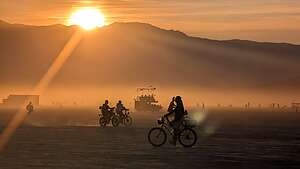 Beautiful sunset the evening of The BurnWhen we had stopped by to say Good Bye to “The Man” last night, I had asked the security guards what time “The Burn” would start the following night, I got a rather vague answer. Like everything at Burning Man, events are not on a strict schedule, but sort of just happen when they happen.
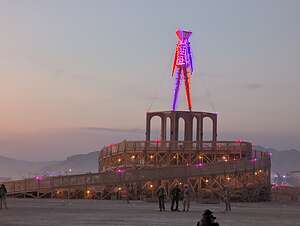
One guard did tell me though, that when “The Man’s” arms go up, you’re too late. Wow! I never even noticed that his arms were down by his side, nor that they were going to move up above his head.
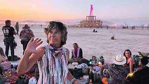 Secured great viewing spotBefore heading out on the playa, we stopped at Treble Makers, for one last time, for some wine and cheese. From there, we could get a good view of the playa and what was going on.
It was a bit dustier out there tonight, which can be annoying, but does have the benefit of a more dramatic sunset.
Although sunset was at 7:30, it began to dip behind the mountains at 7:00, so we hopped on our bikes, hoping to find a good place to view “The Burn.”
 What a brave buckarooThere are over 70,000 people at this year’s Burning Man, and I am pretty sure 99% of them are going to be doing the same thing we were, but surprisingly the playa wasn’t too crazy yet.
We headed directly towards the front of “The Man,” and amazingly got great seats (which means on the hard playa), about 15 feet from the perimeter line, with just one group of people in front of us.
When we parked our bikes, we made sure to take note of exactly where we put them, because when this thing ended it was going to be a zoo. It’s not like we could just look for the two bikes with the LED lights on the wheels, because every single bike looked the same in the dark.
 Enthusiastic participantsWe also locked them together, not because we worried about someone intentionally stealing them, but more because it would be very easy to grab the wrong bike in the chaos at the end.
We started chatting with a very friendly guy in the group in front of us, who was obviously a more experienced “Burner” than us. At one point, he kind of whispered to us that he didn’t want to name drop, but Jen Lewin, the designer of the 2024 Man Pavilion was part of their group. So, we obviously must have chosen good seats, if she was sitting just 10 feet away from us.
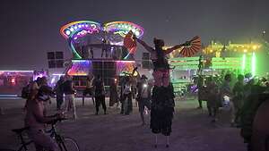
 El Pulpo MagnificoThough we had gotten settled into our positions by 7:30, nothing really got started until 8:30, when it was completely dark. Still there was plenty of stimulus to keep us occupied while we waited - including people in costumes walking on stilts and hundreds of mutant vehicles equipped with colossal sound systems parked along the perimeter, creating a 360-degree wall of music.
Fortunately for us, El Pulpo Magnifico, the iconic 28-foot-tall, colossal, fire-breathing octopus that we had been hoping to see all week, was parked right behind us. It was putting on quite a show - blasting fire from its tentacles, moving his 8 legs up and down, chomping with mouth open and shut, and moving his googly eyes back and forth.
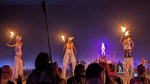 The Procession of the Ceremonial FlameMeanwhile, the Black Rock Rangers and Burn Perimeter Support volunteers had formed a solid human ring, facing away from the Man and toward the crowd. Their job was to hold this safety line for the entire duration of the event, to prevent anyone from rushing the fire.
Event organizers have reported that people have tried to run into the fires in the past, viewing it as a spiritual act of rebirth. One man actually died in 2017 when he broke through two levels of security and actually reached the flames.
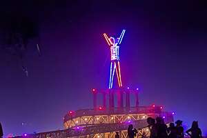 His Arm Are Up!!Okay, so everyone near the front rows, like us, remain calm, and sit back and enjoy the show from afar.
Being “Virgins” (first time “Burners,”) we had no idea what to expect.
Around 8:30, the crowd grew quieter and there was anticipation in the air. The elaborate ceremony was about to begin.
First came the Pre-Show: “The Procession of the Ceremonial Flame”.
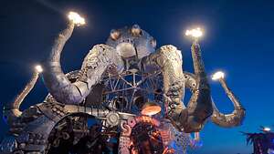 El Pulpo Magnifico is very excitedWell actually, there was one very important step in the Burning Man ceremony ritual that took place in Center Camp last Monday evening. The process involves using a magnifying glass to focus sunlight onto kindling in a large cauldron, called El Diabla, symbolizing the start of the event.
For the following week, the fire in the cauldron at Center Camp is tended by the Fire Conclave, a group of fire performers.
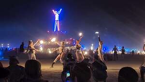 Fire DancersOn Saturday evening, this “first flame” is transferred into a lantern known as the "Luminiferous".
A procession of people carries the Luminiferous from Center Camp to the Great Circle, where the Man stands. The procession is accompanied by the Lamplighters, torchbearers on stilts, who ceremonially light lanterns along the pathways of Black Rock City.
The Lamplighters transfer the flame from the Caudron to each fire group in the Fire Conclave, who stand solemnly by, ready to receive the flame.
 The Angel LookAt this point, “The Man’s” arms are raised towards the sky, a traditional signal for the fire conclave performance to begin, which happens right before the main burn.
Some have interpreted the gesture of the Man raising its hands as a final act of surrender before his destruction. For others, it's a cue for the crowd to prepare for the wild spectacle that is about to begin.
For the next hour, they perform a spectacular, choreographed, show of fire spinning, breathing, and dancing as a "gift... in service to the Man." It takes place in the "Great Circle" inside the perimeter, between the Rangers and the Man.
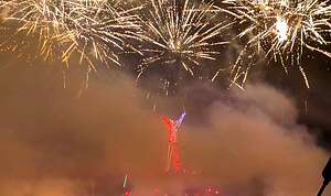 Pyro showThis is not a quiet, solemn performance, but rather a spectacle of "controlled chaos," with hundreds of performers spinning every fire tool imaginable, all at once. There is no single, unified soundtrack; performers move to their own troupe's drummers and the roar of the crowd, The only light comes from the neon on the Man and the thousands of spinning flames.
What an exciting and energy-filled show it was. It was even better than the opening ceremony of the Olympics.
 Pyro showWhen the Fire Concave finished and safely retreated from inside the perimeter, a hush of anticipation fell over the crowd, as the Pyro show was about to begin.
The pyro show starts with what is called the “Angel Look,” a series of dazzling fireworks and white sparkle fountains that surround “The Man” with light before he burns.
About halfway through the pyro show, the fire is lit in the Man’s chest and legs the interior of which was packed with wood soaked in flammable fuel to ensure a hot and quick burn.
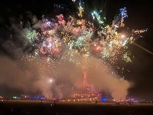 Pyro showThis ensures that the structure begins to burn from the inside, a necessary step before the entire effigy is engulfed in flames.
Then the full show begins, with a deafening show of explosions, rockets, and massive fireballs erupting from the Man himself, and continues until the Man is fully engulfed in flames as the fireworks reach their peak.
All I can say is Wow!!!
But it was not done yet. As the crowd oohed and aahed and cheered, the massive structure, which had been the center of Burning Man life all week, crashed to the ground.
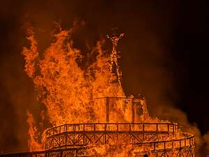 Just before the collapseEveryone kind of sat silently watching the flames continue to consume the beautiful pavilion that had formed his base.
Gradually, the crowds began to disperse and take on the difficult task of finding their bikes among the literally thousands that were out on the playa. Thanks to some careful checking and rechecking beforehand, it didn’t take us too long, allowing us to get a head start on the chaos that would ensue, as tens of thousands of bikes would soon be zigging and zagging across the playa.
It has been quite a finale to our first Burning Man. I guess we weren’t virgins anymore.
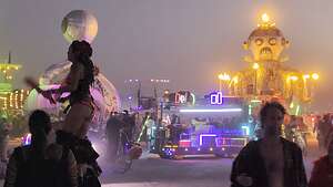 Drive home safely everyoneWe had decided (or I had negotiated) that we would not stay another night to see the Temple Burn, but rather leave very early in the morning to avoid the long line of tens of thousands of cars trying to leave at the same time.
I’m glad Herb had convinced me to come, because it really was quite the experience, but with all the prep involved and how conditions could have been much worse than the beautiful weather we had, we both agreed that once in a lifetime was enough.
There are so many places in the world we haven't seen yet that we have this rule that if we have experienced a place at its absolute best, to not go back and try to repeat an already perfect experience, but to create another perfect experience somewhere new..
Prepping Me and the Motorhome for Burning Man
Tuesday, August 26, 2025 - 1:45pm by Lolo0 miles and 0 hours from our last stop
Travelogue
How Herb Got Me to Yes...
 (1).thumbnail.jpg) The ManWhen Herb announced that he had once again purchased 2 Burning Man tickets, my first response, of course, was: “Not interested. Sell mine and I’ll use my 900 bucks to go somewhere I want to go.”
The ManWhen Herb announced that he had once again purchased 2 Burning Man tickets, my first response, of course, was: “Not interested. Sell mine and I’ll use my 900 bucks to go somewhere I want to go.”
His response: “I’ll hold onto it. You’ll change your mind.”
For the next several weeks, he played hours of YouTube videos of past Burning Men (or is it Burning Mans).
 Are you going to go to Burning Man Amu?I have to admit, that while trying to look disinterested, I did think that the massive art installations from artists around the world out on the playa were rather intriguing.
Then, of course, he played a video of a young guy who took his parents (around our age) to Burning Man and how much fun they had together - trying to play the “Andrew and Tommy will think you are so cool if you go card.”
He went even lower and said that our 15-month-old granddaughter would be disappointed if Grandma Amu didn’t go. He went so far as to make me re-read the poem I had hanging in my office:
One day I will be an old woman
with long silver hair, eyes full of light
and life, and lots of laugh wrinkles.
My children’s children will lay out
with me under the stars by a campfire
on a seashore.
We will listen to the waves make music
as I tell them my stories of wild
adventures, of lived dreams, conquered
fears, and a full life lived.
And I will inspire journeys of their own.
This is the dream of all my dreams.
So I moved from the definite “No” column to “I’ll think about it.”
Over the next few weeks, very non-Herb-like Amazon packages began arriving on our doorstep, mostly stuff to make our old mountain bikes playa-ready :
- fairy lights to decorate the inside of the RV
- LED lights for our wheels so we could be seen by other bikes when riding out on the playa at night
- Headlamps so we could see where we were going
- baskets like the one the wicked witch of the west had on her bike
- big cushiony seats so our butts would survive the bumpy rides on the playa
 Our grandson helping with the bikes
Hmm..Now I was getting interested and shifting a little closer to yes
Then some less fun items arrived to deal with the harsh desert conditions:
- Fully-sealed ski goggles to protect our faces during a dust storm
- A well-fitting N95 mask, respirator, or a thick neck gaiter to protect our lungs in a dust storm
- A good moisturizer or salve because the alkaline dust will dry out your skin
- A spray bottle filled with vinegar to neutralize the alkaline playa dust and prevent a painful condition known as "playa foot." PLAYA FOOT???
 My feeble "Burner" attemptOK, “Playa Foot” shifted me back a bit towards “No Way.”
Herb was starting to lose me here, but then he thought he had me when I ordered an LED-lit cape, which flashed fluorescent colors.
Although he was impressed with my initiative, he made me return it. Not just because it made me look very not me, but because it had sequins on it - a real “no no” at BM because the sequins can fall off violating the BM motto of “MOOP," which stands for "Matter Out Of Place".
MOOP refers to anything brought to the event that is not a natural part of the Black Rock Desert landscape and must be packed out and removed by participants. The list actually included things like sequins and feathers.
However, opening Amazon boxes as if it was Christmas, moved me to a very firm “Maybe I’ll go.”
The final negotiation was Herb agreeing to my request to stay for only 5 nights (including the Burning of the Man) rather than the full 10.
I was now a wishy-washy “Yes.”
Prepping the RV
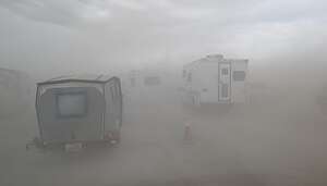 Dust storm upon arrival at the gateThere are two ways to camp at Burning Man: in a tent or in an RV of sorts. There was no way in hell I would spend 5 days in a tent in the harsh conditions of the Black Rock Desert, but fortunately, we have a very comfy, but very old, 1999 Lazy Daze motorhome.
At this point in life, I deserve a comfy bed, a private bathroom, and not being pelted with alkaline desert dust. I am so spoiled.
That being said, while we would be protected from the harsh desert conditions, our poor old motorhome wouldn’t.
 Our campsite on Kilgore and the playaThe fine, alkaline playa dust is incredibly invasive, so Herb had a lot of work to do to seal every possible entry point, a process that would take more days than the 5 days we would actually be spending at Burning Man.
To seal the exterior, Herb used painters and gaffer tape to seal all window, compartment, and door seals. A home air filter cut to size was used to filter the incoming air from our rear Fantastic Fan. The air conditioner had some additional filtration added to help clean the air it would be pulling in.
Despite all that, as demonstrated by the mini-dust storm we encountered during the entry line, the pesky alkaline dust could still find its way in through the cabin air conditioner. We kept it on High which theoretically meant it was in recirculation mode and shouldn’t have pulled in any dust from the outside.
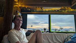 Our Burning Man homeThe fear of having to enter or exit the RV during a dust storm required additional measures for the interior of the RV. All carpeting, and seat cushions were covered with old sheets and heavy duty paper so that we could just throw them out at the end and hopefully once again enjoy our pristine upholstery.
The RV was beginning to look a bit less cozy and more like a construction site.
To soften the decor a bit, Herb added 30’ of fairy lights that were strung around the top of the interior cabinets. He did this once before with Christmas lights while we stayed at a KOA before our move to California and it really helped me get into the holiday spirit. Now it would help me get into a better frame of mind to address the challenges of the potentially very dusty and hot playa.
Our Burning Man Experience
Tuesday, August 26, 2025 - 2:00pm by Lolo0 miles and 0 hours from our last stop - 5 night stay
Travelogue
Arrival and Entry
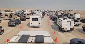 The line to get into BMWe keep our motorhome at our son’s house in Bishop, California, so Herb had gone over to Bishop a few days ahead of me to do the necessary dust-proofing prep work.
The official opening for Burning Man this year was Sunday, August 24 at 12:01 a.m., but our plan was to go a few days later. Herb and I were still negotiating whether we should go on Tuesday (his idea) or Wednesday (mine).
As Herb was finishing up the RV prep work, we began hearing horrible reports from Burning Man about a massive dust storm on opening day (Sunday the 24th) with wind gusts exceeding 50 mph on the playa, causing whiteout conditions and the closing of the gates. The storm destroyed several camps and art installations and injured some attendees.
 Dust storm upon arrival at the gateAfter reopening, the Gate was shut down again later that evening due to heavy rain and thunderstorms, which turned the playa surface into thick, impassable mud, making driving impossible and stranding many participants in the entry line.
It was sounding more and more like this was going to be a repeat of what happened in 2023.
“I’m not going,” I said, “and I think you shouldn’t either.”
Herb ignored me and continued with this prep work.
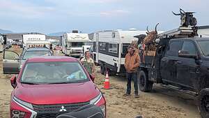 The next morning after sleeping in vehiclesConditions at Burning Man seemed to calm down Sunday night and the gates reopened Monday morning after the playa had dried out enough to drive on.
The forecast for the week ahead looked a little iffy on Tuesday, but then great for the next 5 days after that. That was much better than a forecast that went from good to bad where we would have the possibility of getting stuck there for days like what happened in 2023.
So, on Tuesday morning I joined Herb in the RV (I’m not sure if either he or I knew until that moment whether I would), and we set off on the 5 hour drive to Black Rock City, where Burning Man lives.
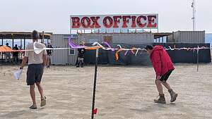 We're In!Gerlach, Nevada is the gateway town to the event and the last place you can get gas and supplies. We were good on both. From there we continued on NV 447 N through Gerlach and followed the signs to turn onto County Road 34 which led us to the official Gate Road, where we entered the line to enter Black Rock City.
Wow! The line didn’t look too bad. Often it can take over 6 hours to get in. The line was inching along slowly until it began to rain, with the possibility of lightning forcing the gates to close once again, and they probably wouldn’t reopen until morning. Darn, we were so close - only about 100 yards to go to get in.
 Our campsite on Kilgore and the playaOkay, this was not ideal, but we couldn’t really complain as we sat in the back of our cozy motorhome sipping a glass of wine, while those in cars had a very long night ahead of them.
To pass the time we tuned into Burning Man Information Radio (BMIR), broadcasting on 94.5 FM on the playa. The station provided a mix of music, news, weather, event information, and public service announcements for participants.
I learned a lot about Burning Man that night.
.thumbnail.jpg) Welcome Home!For example, I learned that a “Sparkle Pony” is a derogatory term for a person that shows up at Burning Man with expensive, fashionable costumes, but lacks basic necessities like food, water, and shelter. With our fully stocked fridge and no sparkly outfits to speak of I was definitely not a “Sparkle Pony.” We started joking that people over 65 that fit the description were “Sparkle Nags.” Okay, perhaps we were having too much wine.
Welcome Home!For example, I learned that a “Sparkle Pony” is a derogatory term for a person that shows up at Burning Man with expensive, fashionable costumes, but lacks basic necessities like food, water, and shelter. With our fully stocked fridge and no sparkly outfits to speak of I was definitely not a “Sparkle Pony.” We started joking that people over 65 that fit the description were “Sparkle Nags.” Okay, perhaps we were having too much wine.
The most interesting conversation, however, was the news that the famous Burning Man orgy dome had been destroyed in the Sunday storm. We laughed some more as to whether we should just go home then. Definitely too much wine.
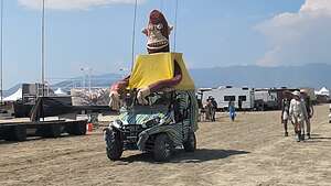 Welcome to the neighborhood!Then the talk turned to people finding their “spirit animal” at Burning Man to encourage self-discovery. You do not choose your spirit animal; rather, you invite it to reveal itself to you through self-reflection and openness. I laughed that I am so uptight that my spirit animal would refuse to come out and reveal itself.
Once we were sure that the line would not start moving until morning, we had a quick dinner and went to bed. So, really for us it was no hardship at all being stuck in line. Unfortunately, the same couldn’t be said about the hundreds of people stranded in their cars.
.thumbnail.jpg) Hi Neighbor!The next morning it wasn’t raining, and everyone kind of milled around at the gate trying to get some idea if and when we would be able to enter. The word was probably about 11 a.m.
Hi Neighbor!The next morning it wasn’t raining, and everyone kind of milled around at the gate trying to get some idea if and when we would be able to enter. The word was probably about 11 a.m.
True to their word, the line did start moving around then, but we had one more hurdle - getting our actual tickets at the Box Office just inside the gate. We parked our car, but being the novices (or more correctly Burning Man virgins) we were, we didn’t sprint like everyone else to the Box Office, so we wound up being pretty far back in the line.
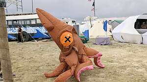 A friendly neighborFinally, it was our turn to be processed. Here’s what happens:
An enthusiastic Greeter hugged us and said “Welcome Home!” Then she handed us the official event guide and the City Map. We shouldn’t have, but we lied about not being “Virgins” (first time “Burners”) so we didn’t get to ring the bell, lie down and make a dust angel, and shout “I’m a virgin no more!” I would have paid $100 to see Herb do this, but we were anxious to just get a good campsite.
We were not officially in Black Rock City. I explained the city layout in the previous stop (So, What is Burning Man) about how the streets are laid out. Herb had gotten some advice on Reddit about how to find a good and quieter campsite at Burning Man.
 Our Burning Man homeWe decided to drive along the outermost street (Kilgore) because that way we would be adjacent to an open playa as opposed to being surrounded by RVs and tents on all sides. Maybe this revealed that we were probably not going to be the rowdiest and most social of “Burners” but hey, at least I was here.
We found a great spot on Kilgore between 3:15 and 3:30 named for their corresponding position on the clock face of the street that radiate out from “The Man”(see City Layout description).
.thumbnail.jpg) Sunset from our campsiteOnce settled in, you are not allowed to move your vehicle until you leave, so our means of transportation were our feet and our tricked out old mountain bikes.
Sunset from our campsiteOnce settled in, you are not allowed to move your vehicle until you leave, so our means of transportation were our feet and our tricked out old mountain bikes.
No need to though. It was a beautiful spot, with the action and chaos of Black Rock City on one side and big open spaces on the other. This was not the playa where all the art installations were, but rather the area where many tent campers set up a home. Also, it's where the temporary airport is, so we got to watch a steady stream of wealthier participants being delivered to their Burning Man experience.
The sunsets from our site were incredible!
Our daily routine
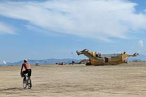 Heading out for a day on the playaBurning Man 2025 had gotten off to a very rough start with a massive dust storm and wind gusts exceeding 50 mph that destroyed many of the camps and art installations, followed by heavy rains which turned the playa into thick impassable mud, forcing the gates to close again.
However, by Wednesday, when we were finally let through the gate, it looked like clear sailing for the next 5 days, with lots of sunshine, temperatures in the upper 80s rather than the 110s that I dreaded, and no big winds.
Black Rock City is pretty big - 6 square miles and a circumference of about 9.5 miles - so the recommended way for getting around is by bike.
.thumbnail.jpg) Typical day at Burning ManSince the playa can be a very harsh place in terms of the alkaline dust, we didn’t want to bring our good mountain bikes, so we got our old ones out of the attic and Herb accessorized them to make them suitable for the playa.
Typical day at Burning ManSince the playa can be a very harsh place in terms of the alkaline dust, we didn’t want to bring our good mountain bikes, so we got our old ones out of the attic and Herb accessorized them to make them suitable for the playa.
That meant big cushiony seats so our butts would survive the bumpy terrain and baskets on the front (like the wicked witch of the west) to hold what we needed for the day.
Most importantly, since we planned to do a lot of our riding at night, we had to make sure we could see where we were going and that other people could see us.
.thumbnail.jpg) Heading back out at nightAfter all, there are 70,000 people in BRC and many of them would also be cruising in random directions along the playa in the dark.
Heading back out at nightAfter all, there are 70,000 people in BRC and many of them would also be cruising in random directions along the playa in the dark.
So, Herb installed headlamps on the front of our bikes so we could see where we were going, and LED lights that changed colors on our wheels so others could see us coming.
Those riders that don’t have suitable lighting are labeled as “Dark Wads.”
So far I had learned that I didn’t want to be a “Sparkle Nag,” get “Playa Foot,” or be accused of being a “Dark Wad” out on the playa. So far, so good, but it was only Day 1.
For the next 4 days, we pretty much got into a groove:
- morning walk or ride around BRC
- back to the RV for lunch and a nap
- back out for an afternoon exploration on our bikes
- back to the RV for dinner
- glass of wine in our camp chairs on the playa-side of our campsite
- stop at our favorite “camp” for red wine and cheese (all free of course)
- then out on the playa again on our bikes after dark
- Back to the RV to sleep and get recharged for another day
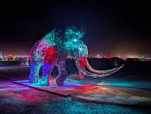 NIght on the Playa
I wouldn’t say we actually immersed ourselves completely into the Burning Man culture, but rather dipped our toes into what we were most interested in and comfortable with, which was basically riding our mountain bikes to see as many of the Artworks as we could. And visit some of the camps.
Camps and Art we enjoyed in the City
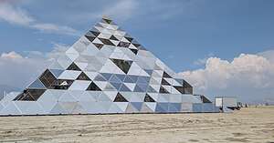 PlayAlchemist Grand PyramidOne of the most ambitious camps was PlayAlchemist whose gift to the community was the 71’ tall PlayAlchemist Grand Pyramid. Inspired by the Great Pyramid of Giza, it isdesigned to be a gathering space and sanctuary during the day and a dance venue at night.
It was created by a Vancouver-based team led by Krystal Commons, and has a steel frame clad with polycarbonate panels.
Once inside the pyramid, you are initiated to embark on an internal journey of personal transformation through alchemy, where the “lead” of your undeveloped consciousness is transformed into the “gold” of deeper knowledge, spiritual awakening, and an enlightened soul.
Wow! It was going to be hard to choose between enlightenment and the free wine and cheese at nearby Treble Makers.
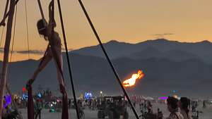 Silk acrobatics at Treble MakerAs I mentioned earlier a “Camp” consists of an organized group of participants that create a specific interactive experience, art installation, or service to share with the rest of Black Rock City. These “gifts,” which include things like food and drink, music and entertainment, and art and absurdity, are given freely to any citizen of Black Rock City who wanders by.
Our absolute favorite camp was “Treble Makers,” a San Francisco-based theme camp offering red wine, cheese, and music.
After dark, the camp transitioned from a more relaxed atmosphere to a "spicier" experience, hosting top-notch House and Techno DJs for dancing and aerial silks for anyone to perform on.
.thumbnail.jpg) Flamingo Phallus Ring TossHerb pretended to enjoy the views of the sun setting over the mountains while a scantily clad young lady was doing some fancy dancing and upside down splits on the silks, blocking his view of the sunset.
Flamingo Phallus Ring TossHerb pretended to enjoy the views of the sun setting over the mountains while a scantily clad young lady was doing some fancy dancing and upside down splits on the silks, blocking his view of the sunset.
Once we discovered this camp, we stopped there every night after dinner for some wine and cheese before riding our bikes out on the playa. For some reason, Herb always had to wait for sunset.
My favorite camp was a bit more wholesome. Its theme was flamingos, and they had several games we could play. One was a ring toss game where you had to throw a hula hoop onto the giant pink phallus of a flamingo. I was amazingly good at it and got ringers on my first two tosses. I was so proud.
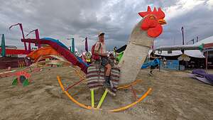 Ride 'em Chicken BoyHerb also got to ride a giant rocking chicken
Every night when we rode back from exploring the playa, we navigated towards a beautiful, brightly lit, temple-like structure, with two interconnected towers, which would bring us back to the Esplanade between 3:30 and 4:00 (streets, not time), making it easy for us to find our way back to the motorhome.
We didn’t know what it was at the time, and we were usually too tired at this point in the day to find out.
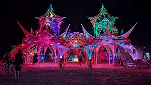 Phantasmagoria campWell, it turns out that it was Phantasmagria Camp, another one of Burning Man’s incredibly ambitious and generous “camps.”
It was absolutely stunning. I wish we had taken the time to experience one of their fancy cocktails in their lounge - free, of course, as is everything else at Burning Man.
While most of the large art installations are located out on the open playa, within the city there was one very large, poignant sculpture of a bright blue bowing face with eyes closed, hands palms together, with fingers pointing upwards in a welcoming gesture.
 NamaskaramThe name of the sculpture is “Namaskaram,” and it was created by Srikanth Guttikonda.
Namaskaram is a greeting of respect that means "I bow to you".
It is a Sanskrit-derived greeting used in Indian, Nepali, and other Southeast Asian cultures, often accompanied by pressing the palms together at the heart in a gesture known as anjali mudra.
The greeting can also be understood spiritually as "the divinity within me bows to the divinity within you," an expression of respect, hospitality, and peace.
Its location in the Central Camp Plaza, at 6:00 and Atwood, serves as a gateway between the playa and the city.
Day 1 of Enjoying the Art on the Playa"
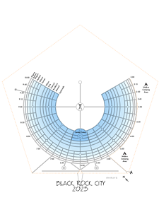 Black Rock City layoutAt Burning Man the barren landscape of the playa serves as the canvas upon which massive artworks rise, some of them so high that they act as navigational aids to get around this vast space.
This is especially true of “The Man,” who stands out on the playa at the absolute center of the “clock”. He is the central landmark from which the entire city radiates.
From The Man, a series of radial streets extend outwards, named for their corresponding time on a clock face, from 2:00 to 10:00. These radial streets make navigation across the vast cityscape relatively straightforward. You can pretty much locate any artwork by using its position relative to "The Man."
.thumbnail.jpg) The Center of Burning ManThe sheer size of the art against the vastness of the desert is a breathtaking sight, designed to evoke a sense of awe and wonder.
The Center of Burning ManThe sheer size of the art against the vastness of the desert is a breathtaking sight, designed to evoke a sense of awe and wonder.
So every morning and every evening, we would head out on our mountain bikes to see as much as we could see. In the following 3 days we rode over 45 bumpy miles, eliminating my fear of getting no exercise at Burning Man.
Let me share some of our favorites.
I guess it would be appropriate to start with the iconic “The Man,”the only artwork that has consistently appeared at every Burning Man since it started in 1986, where he began as an 8-foot tall wooden effigy.
His height has changed many times over the event's history. It reached its greatest height of 105 feet in 2014 and again in 2017. However, the height varies each year based on the event's theme.
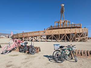 "The Man"The Man for the 2025 event, themed "Tomorrow Today," was a 38-foot-tall effigy that stood at the center of a massive, interactive pavilion called “The World Fair of Unity.”
The entire structure, including the Man and its base, reached a total height of 70 feet.
Unlike the classic, rustic Man of some previous years, the 2025 effigy was designed to match the event's theme. It was a more slender, Art Deco-inspired figure with long, clean lines and an oval-shaped head, giving it a stylized, "retro-future" appearance.
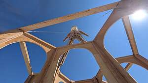 Through the arches in the pavilionThe pavilion, which was designed by artist Mark “Kidnetick” River, is itself an incredibly beautiful piece of art with its dual spiraling ramps and soaring arches through which you can look up and see The Man, proudly standing on his pedestal for all to see. I couldn’t believe that we would watch this all burn down on Saturday.
Inside the Man Pavilion was an interactive art installation called “Carillon” by Steve Brummond. It consisted of three levels of Victorian arched niches which housed giant, oversized bells created from recycled materials.
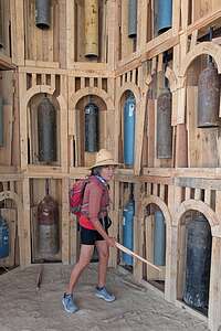 Striking the bells in the pavilion beneath The ManThere were wooden sticks (called strikers) lying on the ground, inviting visitors to pick them up and strike the bells to make music. I patiently waited for my turn, as a cute little 4-year old boy banged away at the bells.
When it was my turn, I struck away with enthusiasm. The acoustics were awesome, but my playing, not so much so. Still, it was very fun.
What to see next? There are two ways to enjoy the art on the playa. The first is to just wander and see what you see. The other is to try to navigate using the Burning Man map, which gives the location of each art installation by saying what o’clock it is relative to the man, and how many feet away from “The Man” it is.
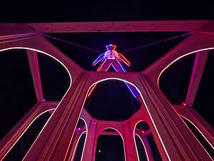 "The Man in his PJsWe tried that method at first, but it was too stressful, so we switched to just wandering aimlessly.
Not too far from “The Man,” we came across what was to become one of my favorite pieces: a large woolly mammoth called “Reborn.”
I couldn’t help myself and peeked at the map and saw that its location was 5.55/860’ meaning it was located at 5:55 o’clock, 860’ feet from “The Man.” Yep, that looked about right.
The sculpture , which was 12 feet tall, 22 feet long, and weighs 8,000 pounds, was created by Montana-based artist Clinton Lesh.
.thumbnail.jpg) In the Embrace of the Woolly MammothIt is made of stainless steel with an iridescent purple, brown, blue and gold heat treated patina, making it shine in the desert sun, and is covered with over 5,000 hand-welded metal "hairs".
In the Embrace of the Woolly MammothIt is made of stainless steel with an iridescent purple, brown, blue and gold heat treated patina, making it shine in the desert sun, and is covered with over 5,000 hand-welded metal "hairs".
Its hand-blown glass eyeballs are filled with LED lights that shine through the metal hairs. It was incredible.
Burning Man encourages people to interact with the artworks so, being the true “Burner” I am, I nestled in its embrace by squeezing myself between its tusks and gazed up into his LED lit eyes. It was love at first sight.
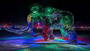 "Reborn" after darkWe continued on, vowing to come back and revisit “Reborn” at night, when the 20 LED panels inside its body, shine out through the sculpture's "wavy hairs," creating a brilliant, glowing effect, changing from red to green to blue. Its hand-blown glass eyeballs were also illuminated, making the prehistoric creature appear to come alive in the dark.
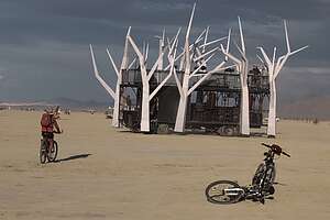 Mutant Vehiclel treeAfter "Reborn," we headed towards the 2nd most iconic art installation on the Playa - The Temple of the Deep, giving right a way to a large white tree that was crossing our paths. Yeah, that's normal.
Like “The Man,” the Temple is something that has been a fixture on the Playa since 2000. When it first appeared in 2000, as the “Temple of the Mind,” it was never meant to be something created each year. However, when one of the building crew was killed in a motorcycle accident, the structure became a memorial.
It was so emotionally powerful that it became a tradition to build a temple each year to serve as a spiritual center where attendees could come to grieve and remember loved ones who had passed on.
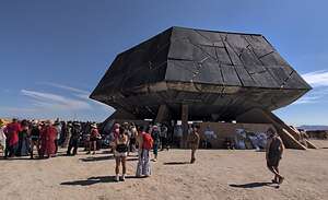 The Temple of the DeepEvery year a different artist is chosen to design that year’s Temple. This year’s Temple, called the Temple of the Deep, was designed by Miguel Arraiz, a Spanish architect.
Unlike the light, airy and uplifting temples of past Burning Mans, this one was dark and intentionally heavy, designed to look like a colossal fractured black rock rising from the desert floor. Its design was heavily inspired by the volcanic rocks of the Black Rock Desert itself.
It was one of the most polarizing temples in Burning Man history, and people tended to either love it or hate it. I’m afraid that my first reaction when seeing what looked like a large charcoal briquette where I expect the Taj Mahal, put me in the latter category, but I eventually came around when I better understood the following metaphor behind the design.
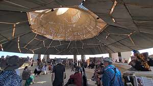 Interior of the Temple of the DeepThe design was inspired by the Japanese art of kintsugi, where broken pottery is mended with gold, thereby highlighting the cracks as a beautiful part of the object's history.
The fractured black rock symbolized the broken pottery, or in this case a broken heart shattered by loss. The light which glowed through the cracks represents the human capacity for healing and resilience, particularly in the face of grief and loss.
 Memorial to a dear friendIn contrast to the rough dark exterior, the interior was a luminous and uplifting cavernous space.
A central opening in the roof, described as a "vortex," allowed a beam of moonlight to shine through.
Arraiz designed the alcoves and chapels and walls in the interior to be a place for people to leave offerings to those that they were grieving for. These offerings included photographs, handwritten letters, or meaningful personal items.
 On to the next art installationThere were Sharpies left alongside the edges of the wall to use to write tributes to loved ones you are still grieving for. I hadn’t planned to, but I found myself writing a tribute to my fun-loving, adventurous friend and next door neighbor who drowned when on vacation in India this year. She always teased me for my reservedness, so I wanted to thank her for always trying to push me to expand my horizons and live outside my comfort zone. I wanted her to know that I took her advice to heart and finally made it to Burning Man. It was a very cathartic experience.
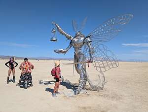 The MothThe following two artworks, with their glittery silver finish, very much fit with this year's “Tomorrow Today” theme, which focuses on innovation and creating the future. They definitely were quite futuristic.
The first one is called “Moth,” but often referred to as the “Steel Moth Lantern Bearer.” It was created by a Russian artist named Vitaly K.
The sculpture tries to capture the tension between Western trinity and Eastern duality.
In his three arms he holds a sword (representing will), a book (representing understanding and knowledge), and a lantern (representing exploration). Each of these are components of human striving and are expressions of the self shaping reality through action, thought, and intuition.
 Making friends?His two legs represent the Eastern emphasis on duality - yin and yang, light and shadow, life and death.
I wanted to pose with the Moth, but it took a while, as this is a popular place for social influencers to pose in their own shiny futuristic costumes. Finally, when it was my turn, I boldly stepped up to the Moth in my non-shiny ware, allmost a bit too boldly, as his sword was actually quite sharp. I gazed up into his compound, beady moth eyes, just like I had engaged with the Woolly Mammoth. After all, art at Burning Man is supposed to be participatory.
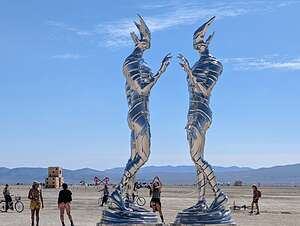
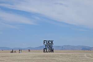 Controversial Elon InstallationI couldn’t find the name of the next futuristic artwork, where two tall brightly silver humanoids reach their hands towards each other in a gesture of acceptance and unity, very much befitting of Burning Man.
An unsanctioned, bold and unapologetic large metal metal sign reading “F**K YOU ELON” sprung up unexpectedly on the Black Rock Desert. Rangers tried to remove it, but it was too heavy.
The irony, besides the fact that Elon is a frequent attendee at Burning Man, is that most people were uploading photos of the sculpture using “Starlink,” which is a company owned by Elon Musk.
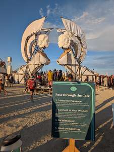 Entry to the Sphinx GatesWe had already ridden close to 10 miles on our bikes, this morning, so we headed back to the motorhome for lunch and a nap, before heading out again later this afternoon for more exploration.
We planned to stop at Treble Makers (see above description of his camp) for a glass of red wine before our night ride out on the playa, but when we saw a large group of people forming and moving in the same direction out onto the playa, we decided to follow, to see what was going on.
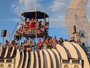 Raucous Crowd seeking wisdomI had heard that there are concerts at Burning Man, but since it’s Burning Man, they are not scheduled, but rather just pop up spontaneously.
I thought this might be one, so instead of having our glass of wine, we hopped on our bikes and followed the crowd, eventually arriving at the Sphinx Gates, where two 34-foot tall sphinx sculptures stood facing each other.
There were crowds of people gathering by the gates and climbing up onto mutant vehicles. It was pretty raucous, and we had no idea what was going on inside.
Then we saw the signs at the entry to the gates, which read Know Thyself?" and “Connect to your Wisdom” and other such inspirational phrases.
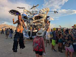 Where's Waldo?There were crowds of people trying to walk through the gates, I guess in search of wisdom and their inner selves, which the project aimed to deliver to those that entered using lights, lasers, and sound to create an immersive and transformative experience.
It was then that Herb and I had the enlightened thought that we could achieve the same transformative experience at Treble Makers, so we hopped back on our bikes and headed back to Treble Makers for an inspirational glass of California red wine.
I’m not sure if I’m cut out to be a “Burner.”
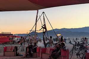 Treble MakersSo back we went to Treble Makers for some enlightening lights, lasers, and sound, topped off with some delicious California red wine and Feta cheese from Spain. It's still amazing to me that these camps provide "gifts" to the community totally free. What a world!!
I had to tear Herb away from watching another sunset at Treble Makers. Those darn girls on the silks kept getting in the way of his view.
We were very excited about our first night ride out onto the playa, when it is transformed into a surreal, dreamlike landscape, as lit-up mutant vehicles cruise across the playa and many artworks designed for night-time viewing are lit up with LEDs, lasers, and fire.
.thumbnail.jpg) Ready to hit the playaIt's kind of like Las Vegas on steroids. It’s totally unrecognizable from the place we had been biking around all day.
Ready to hit the playaIt's kind of like Las Vegas on steroids. It’s totally unrecognizable from the place we had been biking around all day.
It was also utter chaos, as there are no strict roads to follow, but just randomness, as bikes and mutant vehicles randomly cruise in every direction. Thank God Herb had decorated our tires with colorful LED lights so we could be seen.
I’m glad I only had one glass of wine!
We headed towards a large, multi-sensory cube of light, sound, and haptics (stimulating the sense of touch). It is called Apotheneum, or more affectionately, “The Cube.”
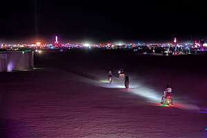 Desert or Vegas?It was composed of two nested chambers made of back-to-back LED nets holding a whopping total of 26,560 light nodes.
The outer chamber was a 40 x 40 x 40 foot cube. Inside it was a 30-foot cylindrical chamber that opened to the sky.
Inside the inner cylindrical chamber there was a 24-foot haptic bed, featuring 96 triangular tiles with embedded servo motors that emitted vibrations in sync with the light and sound, creating an immersive, multi-sensory experience for those lying on it.
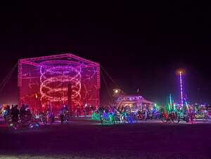 ApotheneumOften, in fact almost always, when I am writing up a trip, I discover information that I wish I had known when we were there, so I could have experienced them first hand, like that sensory bed!!
By now, we had learned to expect the unexpected at Burning Man, so we were unphased when a 65-foot yacht named Christina cruised past us. This was one of Burning Man’s “art cars” or “mutant vehicles.”
A “mutant vehicle” is defined as a vehicle that is "radically and permanently mutated" to the point where it no longer resembles a standard street vehicle, or is dramatically out of its normal context.
.thumbnail.jpg) ChristinaIn order to be allowed to drive out on the playa, it must be licensed by Burning Man’s “Department of Mutant Vehicles (DMV). That’s right! Burning Man has its own DMV.
ChristinaIn order to be allowed to drive out on the playa, it must be licensed by Burning Man’s “Department of Mutant Vehicles (DMV). That’s right! Burning Man has its own DMV.
Since Christina is placed on a cement truck chassis and now sails across the desert rather than Lake Tahoe, she falls in the latter category of being dramatically out of her normal context.
Christina has been a staple at Burning Man for decades and even won “Art Car of the Year” in 2010.
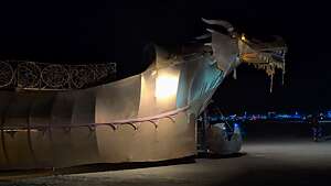 Mutant dragon passing throughIt was created by Flipper Manchester, who was originally hired to demolish the yacht but decided to convert it into an art car for Burning Man instead.
With the help of donated labor and roughly $20,000 of his own funds, Manchester put the boat on the chassis of a cement mixer, painted turquoise waves around the hull of the boat, outfitted it with a sound system and lights, and tore out all the bedrooms down below and made a huge ultra lounge where famous DJs from around the world play.
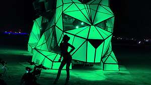 Huggzilla with dancerContinuing on, we gravitated towards a brightly-colored cat, cycling through pink to green to blue.
Her name was Huggzilla, and instead of fur, she was covered with Plexiglas panels that were illuminated for light shows on the playa at night.
She was another gathering place for social influences who posed and danced in front of her.
.thumbnail.jpg) Nested HeartThere was so much to see that it was a bit overwhelming. Talk about stimulus overload. It’s impossible to describe them all, but here are just a few more art installations that we liked. And to think that this was only our first night!
Nested HeartThere was so much to see that it was a bit overwhelming. Talk about stimulus overload. It’s impossible to describe them all, but here are just a few more art installations that we liked. And to think that this was only our first night!
Next up was Nested Heart, two cormorants, lit up from inside, with wings gently touching, as if they are drying their wings on the playa.
.thumbnail.jpg) Totem RockThis gesture is meant to symbolize a reflective pause after a triumph and an opening of the heart to give thanks - perhaps for the successful catching of fish?
Totem RockThis gesture is meant to symbolize a reflective pause after a triumph and an opening of the heart to give thanks - perhaps for the successful catching of fish?
Inside the bird there was a nest that visitors could enter and reflect on their own personal challenges and triumphs.
Entering the nest triggered an audio loop of music to start playing, enhancing the contemplative experience.
Of course, I didn’t know any of this until afterwards, so we never got a chance to enter the nest and reflect on our challenges and triumphs, but I bet Herb’s challenge would have been trying to get me to agree to come here, and his triumph was that I did.
 "The Man"The next artwork we came across was a huge head, just sitting on the playa, its face cycling through a series of reds, blues, greens, orange, and yellow. I am not totally sure, but I think this piece is named Totem Rock, and if so its purpose is to serve as a channel between humans and spirits and ancestors. If not, he's just an interesting face, but I doubt that, because everything at Burning Man has a deeper, spiritual meaning than just aesthetics.
There was still a lot more to see, but we were pretty tired from a very long productive day. We had ridden 18 bumpy miles on our old mountain bikes today. Plus, we had 2 more full days to explore. So we headed back towards the esplanade where we would weave our way through the streets of Black Rock City to find our motorhome.
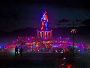
But first, a good night to "The Man," who was pretty much visible at night from anywhere on the playa. I wonder if he knew that he had only 2 more days to live, but I guess after almost 40 years, he was getting used to it.
Day 2 of Enjoying the Art on the Playa"
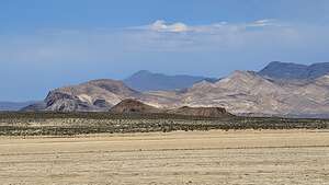 To the outer edges of the playa we goWhen we woke up on Thursday, I said to Herb, “I’m not sure what we are going to do today, because I think we’ve pretty much seen everything.”
“I highly doubt that," he said, pointing the the Burning Man map with over 326 art installations listed.
“Maybe a lot of them were destroyed in the severe wind and dust storms before we arrived. Remember the Orgy Dome was obliterated.”
So we decided to do a deeper dive, or more accurately a wider dive, by biking around the entire perimeter of the part of the playa that is defined as Burning Man.
 Waves into SkyBlack Rock City has a 9.2-mile-long Trash Fence, the purpose of which is to catch MOOP (Matter Out Of Place), like trash and debris from blowing off the playa and into the surrounding desert. It also acts as the boundary of Black Rock City, so we would use it as our guide during our perimeter tour.
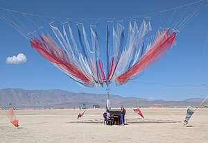
I absolutely loved the first piece we came to, which was called Waves into Sky. So, I guess we hadn’t seen everything.
 Tea Anyone?The sculpture consisted of a central pole, with a series of red, white, and blue light and airy fabric wings emanating from it, held in place by a wire above.
Beneath it sat a piano, which welcomed visitors to participate by making their own waves of sound.
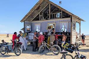
The fun part about riding out on the playa is that you never know what to expect, so we weren’t surprised when we came upon a scene right out of the late 1800s - an old cabin with a porch out front from which a woman with a parasol was serving tea.
.thumbnail.jpg) Apocalyptic Deep Sea PortalContinuing on, we rode towards a large open wooden cube with crocheted, handmade sea creatures and apocalyptic emblems hanging from its frame. Its name was Apocalyptic Deep Sea Portal.
Apocalyptic Deep Sea PortalContinuing on, we rode towards a large open wooden cube with crocheted, handmade sea creatures and apocalyptic emblems hanging from its frame. Its name was Apocalyptic Deep Sea Portal.
The sea creatures are intended to make people reflect on the importance of the ocean and our interdependence with its creatures.
The artwork acts as a conceptual gateway for participants to travel between a non-apocalyptic world and an apocalyptic one, with the sea creatures serving a guides between the two realms.
.thumbnail.jpg) Beast ModeWe preferred to stay in the non-apocalyptic one, so we took a chance and headed out to the “Trash Fence” to trace the perimeter of Black Rock City.
Beast ModeWe preferred to stay in the non-apocalyptic one, so we took a chance and headed out to the “Trash Fence” to trace the perimeter of Black Rock City.
Ok, maybe we still were in apocalyptic mode because the first sculpture we came upon was all black and had a scary monster in the middle covered in spikes and entwined with serpents and tentacles. It was appropriately called Beast Mode.
However, there was also hope, because it was surrounded by lamp posts adorned with crystals and lights that emitted a warm glow, creating a contrast with the dark beast.
As many of Burning Man’s art installations are, this one was interactive in that as you walked through it talked about the need to replace hate in this world with love.
.thumbnail.jpg) Life TripsSo like the last sculpture, this one two symbolized a dichotomy, this time the balance between lightness and dark, fear and wonder, and love and hate.
Life TripsSo like the last sculpture, this one two symbolized a dichotomy, this time the balance between lightness and dark, fear and wonder, and love and hate.
It was pretty quiet bicycling out near the perimeter, and we hardly saw another soul, until we came upon another cyclist, or at least a sculpture of one.
The piece was called Life Trips and like the past two works, it too was about life struggles and balance, cleverly illustrated by a cyclist struggling to keep his balance as he is about to do an unsuccessful “endo” over the front of his bike.
 Herb doing fancy stuffFor the artist, this theme was personal and his “Life Trips” was a perfect metaphor for stumbling over inner demons and past traumas along our path through life, and the struggle to find balance and happiness.
Then it was back to the motorhome for lunch and a nap. We had already biked 10 miles this morning, so we deserved a little siesta.
 Getting a little helpIt was pretty much our routine every day to get out in the morning when it was cool, hang out in the air-conditioned motorhome during the heat of the day, when the lighting wasn’t good for photography anyway, and then head out again in the evening when the playa came alive.
This was to be our most participatory night of all. Up until now, we pretty much didn’t realize what we were missing at some of the art installations until we got home and I started doing research to write this trip up.
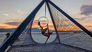
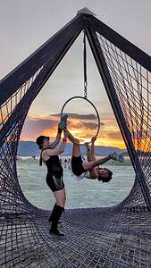
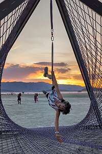
But we couldn’t miss the hidden meaning of the netted pyramid with the gymnastic hoop hanging down from its vertex, just crying out for us to give it a go.
 I can do fancy stuff tooJust to set the scene, everyone else gathered around was at least half our age or less, so when we stepped up, there were lots of oohs and ahs from the young'ns, who probably thought they were about to watch a train wreck.
However, despite our approaching 70, both Herb and I are quite athletic and strong. We rock climb in a gym, work out in a fitness center, run, mountain bike, hike, and swim.
So, Herb had no trouble pulling himself up and getting to a sitting position inside the hoop, before venturing into fancy stuff.
I, however, being shorter, had a bit more of a struggle pulling myself up into the hoop, so the woman whose installation it was, gave me a little ooch.
.thumbnail.jpg) Waves in the SkyOkay, maybe a big ooch. But from there, I did fancy stuff of my own. Boy that was fun!
Waves in the SkyOkay, maybe a big ooch. But from there, I did fancy stuff of my own. Boy that was fun!
I was glad that I had my biking shorts on under my dress
We just love biking around playa at night, so with no real destination in mind, we just randomly went towards the lights - like moths.
Waves in the Sky, which we had already seen this morning, lured us in, as it was even more beautiful at night, set against an amazing sunset.
.thumbnail.jpg) Golden Gate bridge photo bombs the Sphinx GatesThere were a lot more people out now than during the day.
Golden Gate bridge photo bombs the Sphinx GatesThere were a lot more people out now than during the day.
From there, in the distance we saw the 34-foot high Sphinx Gates, so we headed that way.
Wow! What a difference from yesterday where there were literally hundreds of people trying to get through the gates for a lights, laser, and sound event aimed at helping those you passed through find wisdom and their inner selves.
.thumbnail.jpg) Sphinx Gates at nightNow, there was no one and no sign of anything having happened here, except for the two sphinxes staring into each other's eyes. It was like we dreamt it.
Sphinx Gates at nightNow, there was no one and no sign of anything having happened here, except for the two sphinxes staring into each other's eyes. It was like we dreamt it.
To make the scene even more dreamlike, we watched as the Golden Gate Bridge drove by in the distance. That was quite a juxtaposition.
I guess the Sphinxes didn’t want to be outdone by the Golden Gate Bridge, so a little later they put on their own show in vibrant reds and blues. They showed him!!
There was one last task we had to do before heading back to the motorhome and that was to say our final farewells to “The Man,” because tomorrow he would burn.
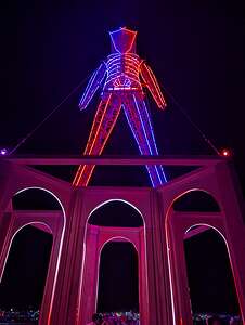 Bye Bye Burning ManWe weren’t the only ones with this idea, so we parked our bikes amongst the hundreds of others and solemnly walked up the beautiful wooden spiraling ramp to the soaring arches upon which he stood.
Before long, the security guards asked everyone to leave, so they could begin securing the perimeter for tomorrow night’s big pyrotechnic display.
Securing the perimeter for the Man Burn is one of the largest and most critical safety operations of the entire Burning Man event. It is a highly coordinated effort involving hundreds of trained volunteers.
The Burn is supposed to be quite a spectacular event, starting with an hour-long choreogrpahed show of fire-dance troupes from around the world, followed by a massive fireworks display that erupts from The Man himself, with explosions, rockets and massive fireballs that roll across the sky, eventually engulfing The Man in flames, and concluding with his collapse and crashing to the ground.
I admit to feeling sad about this beautiful structure being turned to ashes, but "ephemeralness" is a core principle of Burning Man, as the city is built and then completely dismantled to leave no trace that it ever existed behind. So the Burning is a central part of this tradition.
Day 3 of Enjoying the Art on the Playa"
 Humanoid?We had seen so much art over the last two days, that I couldn’t picture that there could possibly be that much more, but there was. In fact, I think it would take weeks to see everything.
Well, sure enough, we did see a lot of new cool stuff.
I'm not sure of the name of the first one, but it was some kind of huge humanoid reaching out her hand to something beyond our field of vision or perhaps something only she could see?
She was so large that I could comfortably nestle in her armpit.
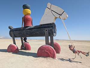 One Tin SoldierA bit further on we came to an area full of worn, weathered children’s toys - a monumental stack of alphabet blocks inviting one to climb and play on, an old metal pair of jacks laying scattered about, a giant 12-foot yo-yo buried in the dust, and One Tin Soldier, that sits upon a 24-foot wooden horse, whose reins held a swing, welcoming visitors, such as me, to come and play on, so I did!
The project is an homage to childhood wonder and nostalgia, encouraging participants to feel like small children again by shrinking them next to the colossal toys.
.thumbnail.jpg) Moonlight LibraryWe all need to rediscover our inner child. I have no problem with that. I have more of a problem finding my inner adult.
Moonlight LibraryWe all need to rediscover our inner child. I have no problem with that. I have more of a problem finding my inner adult.
I love books, and I even brought 3 of them thinking I would have some downtime to read. Well, guess what? There is no downtime at Burning Man.
So as a consolation, I was very excited to learn that Burning Man has a library, called the Moonlight Library, that encourages people to explore the question, “What does it mean to be human?”
.thumbnail.jpg) Back of the Moonlight LibraryThis towering two-story installation was designed to look like a Gothic romantic ruin of an ancient library. Rather than a complete building, all that remained was a corner of what was once a much larger, multi-story structure that had otherwise deteriorated.
Back of the Moonlight LibraryThis towering two-story installation was designed to look like a Gothic romantic ruin of an ancient library. Rather than a complete building, all that remained was a corner of what was once a much larger, multi-story structure that had otherwise deteriorated.
Placing these books in a ruined library, suggests that even as physical structures crumble, human narratives and shared experiences endure.
On the back of the library there were faux marble tablets containing quotes about the importance of stories in our lives.
 Bookshelves of the Moonlight LibraryOne particular quote that resonated with me was: “What you speak becomes a seed. In another heart, it takes root. Stories are flaxen words, woven across time, connecting us to souls we've never met..
The walls of the library were lined with massive bookshelves filled with thousands of real “weathered” books.
Of course, like most installations at Burning Man, this one was interactive.
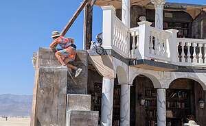 Up to the 2nd FloorParticipants could take physical books from shelves, place them on a kiosk to listen to them. Some of the books on the shelves had sensors, so when someone touched the spine, it softly played an audio recording of an anonymous personal story.
There was even a hidden "Entity Room" for personal reflection.
These stories were collected by artists at previous Burning Man events, essentially creating a library of human experiences - joy, sorrow, fear, and hope.
 And down againIt served as an archive of collective memory, encouraging participants to author their own stories and reflect on their life narratives from the perspective of their final chapter, giving them time to rewrite their narratives before it was too late.
The contemplative mood was enhanced by a lone court musician, dressed in shiny gold from head to foot, standing in front of the bookshelves, playing melodious tunes on a saxophone.
There were additional bookshelves on the second floor, reached by two precarious staircases on either side of the building, neither of which had hand rails.
 Ad AstraNeither looked particularly safe, but I chose to clamber up the two to 3-foot blocks on the left sides as opposed to the ridiculously narrow ones on the right, hoping to not have my “final chapter” arrive before I had a chance to rewrite my story.
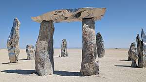
We never knew what to expect next, but after leaving the Library, we came upon what looked like a modern-day Stonehenge.
.thumbnail.jpg) Ad AstraIt was called Ad Astra, and it consisted of six monumental sculptures arranged in a circle, with a diameter of 13 meters.
Ad AstraIt was called Ad Astra, and it consisted of six monumental sculptures arranged in a circle, with a diameter of 13 meters.
The sculptures were crafted from a combination of artificial stone and polished stainless steel, which blended ancient-looking surfaces with more shiny, futuristic reflective finishes, symbolizing the union of past, present, and future.
Although beautiful by day, with the desert and us reflected in the polished steel, it is supposed to be even more impressive in the dark, when a warm, pulsating light emanates from inside the sculptures, accompanied by a deep, space-like soundscape.
.thumbnail.jpg) Vessel of LoveToo bad it is so far out on the playa, almost a mile further than “The Man,” so we probably wouldn’t venture this far out again in the dark.
Vessel of LoveToo bad it is so far out on the playa, almost a mile further than “The Man,” so we probably wouldn’t venture this far out again in the dark.
While the last two installations emphasized the profound connections between the past and the future, Vessel of Love was pure fun, closer in theme to the “One Tin Soldier,” which pushed us to embrace our “inner child.”
This vibrant red, 21-foot high, 46-feet long double slide built in the shape of an infinity heart invited participants to climb up its ladders and slide down either of the two intersecting slides, with childlike abandon.
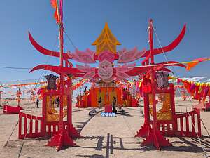 Afterlife ReincarnateBut at Burning Man, even things that appeared as pure fun always seemed to have a deeper meaning as well. This piece was intended as a celebration of connection, joy, and infinite love.”
Yesterday when riding around the perimeter of the playa, we had seen orange barrier tape blocking an area off in the distance. Thinking it was an installation that had been destroyed by the wind and dust storms at the beginning of Burning Man, we ignored it and rode in a different direction.
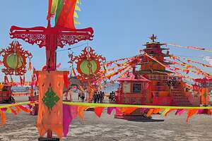 Afterlife ReincarnateThen the next day, we got a little closer and saw that we had been mistaken, and instead of a destroyed installation, it appeared like we had arrived in Thailand.
The installation, which was called Afterlife Reincarnate, was an amazing 150x150-foot multi-sensory piece, arranged in a Tibetan-inspired mandala, a design used in Buddhist and Hindu traditions as a spiritual tool for meditation.
With its mystical fire-breathing dragons, fluttering prayer flags, and multiple shrines and gates, it was designed to virtually “teleport” participants to the ancient temples, pagodas, and stupas of Asia.
 MermanAt night, it must have been even more stunning, as it lit with fluorescent lights, LEDs, and blacklights to create a vibrant, otherworldly beacon on the playa.
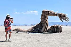
Continuing on, we came upon a huge wooden man swimming across the desert. His name was Merman,” and he was created by a Ukrainian team led by Andrii Krapyvchenko.
The 12-meter long sculpture was constructed from 288 wooden blocks and depicts the head, back, and arm of a giant man appearing to swim through the ground. It is meant to be a symbol of endurance and overcoming obstacles, very appropriate for a piece from Ukraine.
Merman was originally supposed to appear at Burning Man in 2021, but was delayed due to Covid and the war.
 Rose WondersWe left the Merman behind and rode towards what we thought was a large King Kong holding a small woman in the palm of his hand.
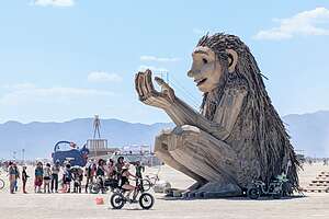
But when we got closer, we saw that instead it was a massive, gentle-looking troll, and the people in his outstretched hand had gotten there voluntarily climbing a hidden staircase. In fact, they waited on line for the privilege.
This piece is called Rose Wonders and it was created by the renowned Danish artist Thomas Dambo, who has made it his worldwide mission to transform recycled materials and trash into something magical - specifically trolls. Rose Wonders is the 158th troll to join his global collection.
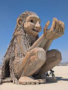 Rose WondersMost of Dambo’s trolls have a poem associated with their themes, which in the case of Rose Wonders was the desire to evoke a sense of connection with nature, reflection, and wonder. I don’t think he could have possibly made a more appropriate choice than G.E. Stooke’s poem “I Wonder if it Wonders, which ends with the following stanza:
I wonder if it understands, the world is a connection,
And everything we do comes back again as a reflection
I wonder if it speaks, I wonder what it wants to say
And wonder if it understands tomorrow is today
Coming full circle to the Burning Man 2025 theme of “Tomorrow Today”
Sorry to see it all end, but tonight was the climax - “The Burning of the Man.” Time to get back to the motorhome and get ready for the big event.
So, What is Burning Man
Tuesday, August 26, 2025 - 9:45am by Lolo0 miles and 0 hours from our last stop - 5 night stay
Travelogue
A bit of Burning Man history
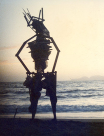 1986 Baker Beach - 8-foot ManBurning Man was born on June 22, 1986 (so he’s a Millenial) as a small, spontaneous bonfire ritual on Baker Beach in San Francisco, where a group of about 20 people gathered to watch the first burning of “The Man,” which at that time was an 8-foot-tall wooden effigy to celebrate the summer solstice,
The event became an annual tradition, each year attracting more and more people. By 1990, the crowd had grown to 800 and the “Man” had grown into a 40-foot structure.
By 1990, the event had grown too large for the beach with as many as 800 people attending. Citing fire hazards, the Golden Gate Park Police wouldn’t let them burn “The Man,” so the organizers picked him up and took him to the Black Rock Desert, a vast, flat, and harsh ancient lakebed in Nevada.
 1990 Black Rock Desert 0 40-foot ManThen on Labor Day weekend to an audience of only 90 people, they successfully burned “The Man,” and its new, permanent home was established.
To this day, each year he is burned on the Saturday of Labor Day weekend.
In the 1990s the event grew from a small desert gathering into a temporary city, built each year from scratch by its participants.
For one week, it rises from the flat, arid lakebed of the Black Rock Desert in Nevada, becoming one of the largest "cities" in the state, with over 70,000 temporary residents, only to be completely dismantled and removed at the end, as if it were never there.
 2000 Black Rock Desert - the First TempleIn 2000, the “Temple of the Mind” was built as an art project. However, when one of the building crew was killed in a motorcycle accident, the structure became a memorial.
It was so emotionally powerful that it became a tradition to build a temple each year to serve as a spiritual center where attendees could come to grieve and remember loved ones who had passed on.
Every year, the temple is burned on the Sunday of Labor Day weekend. It is a quiet, somber ceremony, in contrast to the celebratory burn of "the Man" the night before.
In 2004, Larry Harvey, one of the co-founders of burning man wrote the 10 Principles that participants were expected to follow:
- Radical Inclusion: Anyone is welcome
- Gifting: You give gifts without any expectation of return
- Decommodification: There is no commerce, advertising, or corporate sponsorship
- Radical Self-reliance: You must bring all of your own survival supplies (water, food, shelter) for the week
- Radical Self-expression: You are encouraged to be your unique self
- Communal Effort: People work together to build the city, art, and camps
- Civic Responsibility: Participants are responsible for public welfare and following laws
- Leaving No Trace: This is a critical rule. The community is committed to leaving the desert exactly as it was found. Everything you bring, including trash, must be packed out with you
- Participation: Everyone is expected to contribute to the experience
- Immediacy: The event is focused on being present in the moment and experiencing the world around you
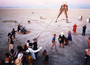 Illustrating the 10 Principle of Burning Man
Burning Man 2025 Theme
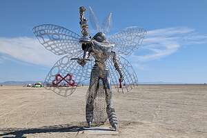 MothEach year, Burning Man has a unique theme, which is meant to inspire and guide the artistic, cultural, and personal expression at the event.
Themes are announced in advance and influence the art installations, camps, and participation of attendees throughout the week.
For example, the 2024 theme was "Curiouser & Curiouser," inspired by Alice in Wonderland, and the 2025 theme is "Tomorrow Today," which focuses on innovation and creating the future.
This theme invites participants to imagine the future in new ways, and to make it real through our collective actions, drawing inspiration from past world fairs that celebrated progress, culture, and art.
This futuristic theme also allowed attractive young ladies to dress in shiny silver metallic costumes.
Burning Man City Layout
 Black Rock City layoutThe city is laid out as a massive C-shaped arc, resembling a giant clock face.
The vast, open area inside the C-shape is known as the "playa," filled with massive sculptures, art installations, and "mutant vehicles" (art cars). This is why I came to Burning Man.
The Man stands out on the playa at the absolute center of the “clock”. This is the central landmark from which the entire city radiates.
Far out on the playa beyond The Man, directly at the 12:00 position is the Temple, which serves as the city's spiritual and contemplative heart, a place for remembrance and letting go.
From The Man, a series of radial streets extend outwards, named for their corresponding time on a clock face, from 2:00 to 10:00. These radial streets make navigation across the vast cityscape relatively straightforward.
Intersecting these radial avenues are a series of concentric, curved streets. The innermost of these is the Esplanade, the city's bustling main promenade that faces the open playa and its stunning art installations.
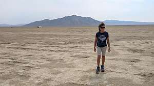 My backyard on Kilgore StreetMoving outwards from the Esplanade, the subsequent streets are named in alphabetical order. For the 2025 gathering, the city's concentric streets pay homage to visionary writers whose works have explored the complex intersections of humanity, technology, and the future. So the first street after the Esplanade is Atwood (A) for Margaret Atwood, author of the Handmaid’s Tale and the furthest street is Kilgore (K) for Kilgore Trout, a recurring character in Kurt Vonnegut’s science fiction stories.
We stayed on Kilgore Street, because it was at the very edge of the arc, where it was much quieter because instead of being in the thick of things, we were right on the edge of another playa.
This logical system made navigating throughout the city easy, even for the spatially challenged, such as me.
The Concept of Camps
.thumbnail.jpg) Camp Bajie's Lair White TigerThere are two categories of “Burners” at Burning Man: those that are part of an official “camp” or those who go on their own (which is what we were).
Camp Bajie's Lair White TigerThere are two categories of “Burners” at Burning Man: those that are part of an official “camp” or those who go on their own (which is what we were).
A camp is an organized group of participants that creates a specific interactive experience, art installation, or service to share with the rest of Black Rock City. These “gifts” are given freely to any citizen of Black Rock City who wanders by.
.thumbnail.jpg) Purrfect Punch Camp's HuggzillaSome examples of camp “gifts” are food and drink, sound and entertainment, services such as bike repair, workshops such as yoga classes and meditation sessions, and art and absurdity.S
Purrfect Punch Camp's HuggzillaSome examples of camp “gifts” are food and drink, sound and entertainment, services such as bike repair, workshops such as yoga classes and meditation sessions, and art and absurdity.S
Camps are the heart and soul of Burning Man. They are the living, breathing neighborhoods that transform the empty desert into the vibrant metropolis of Black Rock City.
People that are not part of an official camp, such as us, are citizens of Black Rock City. We fell into this group. We even got a passport.
Participants like us camped in “open camping” areas, typically located on the outer streets.
Camp sites are available on a first-come, first-served basis, so we drove around a bit before selecting ours on Kilgore Street, which was as far out as you can go.
Art on the Playa
The art on the playa at Burning Man is unlike art in any other gallery, museum, or even sculpture park in the world.
There are four major categories of artworks:
- Honoraria Installations: These are the large-scale, often theme-related projects that have received funding grants from the Burning Man Project to help bring them to life. They form the core of the planned "art gallery" on the open playa
- Spontaneous Art: These are the smaller, unregistered art pieces pop up, created by participants who simply want to contribute to the creative landscape
- Mutant Vehicles (Art Cars): These are radically modified vehicles, transformed into everything from fire-breathing dragons and giant fish to pirate ships and glowing jellyfish. I think they are the most fun in that they create an ever-changing dynamic environment
- The Man and The Temple: These are the two central, iconic pieces that are created new each year, often reflecting the annual theme.
.thumbnail.jpg) Rose Wonders
Rose Wonders
.thumbnail.jpg) The ManThe Man's design is handled by a hand-selected crew of builders and managers within the Burning Man organization. While the iconic figure of the Man remains constant, the structure it stands upon—the Man Base or Pavilion—is designed to reflect the festival's annual theme.
The ManThe Man's design is handled by a hand-selected crew of builders and managers within the Burning Man organization. While the iconic figure of the Man remains constant, the structure it stands upon—the Man Base or Pavilion—is designed to reflect the festival's annual theme.
In contrast, the Temple is designed by different artists each year, chosen through a grant program. This year’s Temple, called the Temple of the Deep, was designed by Miguel Arraiz, a Spanish architect. The fractured, black rock-like structure he created is meant to symbolize grief, loss, and healing.
 The Temple of the DeepThe vast, barren landscape of the Black Rock Desert serves as the canvas for massive artworks, sometimes several stories high. The sheer size of the art against the vastness of the desert is a breathtaking sight, designed to evoke a sense of awe and wonder.
Many of them are so large that they art landmarks across the playa, serving as navigational aids and gathering points.
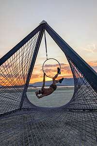 Participatory ArtIn line with the Burning Man principle of Participation, the art at Burning Man is not meant to be passively observed from afar, but rather to be touched, climbed on, crawled through, and experienced.
The participant's interaction is often what completes the piece, turning it from a static object into a dynamic experience.
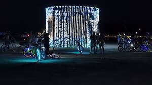 Night on the PlayaAt night, the playa transforms into a surreal, dreamlike landscape as lit up mutant vehicles cruise across the playa and many artworks designed for night-time viewing are lit up with LEDs, lasers, and fire. This was my favorite time of day to be on the playa.
Another characteristic of the art is its ephemeralness. They are installed in the days leading up to the event and must be completely removed without a trace afterward. Some of the art is moved to private collections, museums, or public spaces. Others, like the iconic “Man” and the “Temple” are burned.
Description
[img_assist|nid=11876|title=My backyard on Kilgore Street|desc=|link=node|align=left|width=300|height=169]
Vermont (and the Berkshires)
Sunday, September 28, 2025 - 5:30pm by Lolo miles and hours from our last stop - 5 night stay
Travelogue
Day 1 - Williamstown and MASS MoCA
 Williams CollegeThis trip really had legs - starting off just the two of us “Up Island” on the Vineyard, followed by the climax of 7 wonderful days in an incredible house on Edgartown Harbor with the kids and grandkids, and now the wind down driving the scenic roads of the Berkshires and Southern Vermont in search of Fall foliage.
Our first stop on our foliage tour was Williamstown, a place very near and dear to our hearts, as it was where both our sons and one of our daughter-in-laws went to college.
We took the scenic way to get there via the Mohawk Trail (Route 2), which stretches 60 scenic miles across northern Massachusetts) from Greenfield on the Connecticut River to Williamstown near the New York border.
.thumbnail.jpg) The serpent behind the Clark InstituteMore than just a road, it's a historic and cultural corridor that offers some of the most stunning vistas in New England.
The serpent behind the Clark InstituteMore than just a road, it's a historic and cultural corridor that offers some of the most stunning vistas in New England.
Unfortunately for us, we were a little early for many leaves to be changing.
However, it’s still a lovely drive with quite a bit of history. Long before it was a highway, the Mohawk Trail was an important footpath used by Native American tribes for trade, hunting, and travel between the Connecticut and Hudson River valleys.
In 1914, the state opened it to cars, making it New England’s first “scenic tourist route.” This transformed the trail into a popular destination for "auto-touring," with gift shops, inns, and attractions springing up along its path.
 MASS MoCAWhen we got to Williamstown, we checked into the Maple Terrace hotel, along the Mohawk Trail at the edge of town.
Noting the lack of his Maple tree which is usually a vibrant red around this time, he told us that it had been a very dry and warm season, so the leaves were turning brown and falling off the trees before they had a chance to turn vibrant. Oh well, maybe things would be better further north.
 MASS MoCAThe motel had a lovely garden area with Adirondack chairs where we enjoyed some wine and cheese before heading into town to find a place to have dinner.
Rather than walk along Route 2, I suggested we walk through the cemetery behind the motel. I told a very skeptical Herb that I remembered that when on a run over a decade ago, I found paths that would bring me over to the college.
.thumbnail.jpg) MASS MoCANot trusting my fairly poor spatial skills, he reluctantly followed, but much to my relief, we popped out on Water Street just as it was getting dark. And to add to my gloating, we were right by the Water Street Grill, a restaurant we frequented often back in the day. Wow! This was a blast from the past, as we had eaten here with the boys and their friends many many times.
MASS MoCANot trusting my fairly poor spatial skills, he reluctantly followed, but much to my relief, we popped out on Water Street just as it was getting dark. And to add to my gloating, we were right by the Water Street Grill, a restaurant we frequented often back in the day. Wow! This was a blast from the past, as we had eaten here with the boys and their friends many many times.
We had had a big lunch with the kids in Falmouth before parting, so we weren't all that hungry, so we just ordered some salads.
.thumbnail.jpg) MASS MoCANot wanting to go back to the hotel through the dark park and cemetery, we took the less adventurous way along Route 2.
MASS MoCANot wanting to go back to the hotel through the dark park and cemetery, we took the less adventurous way along Route 2.
Besides its incredible natural beauty, Williamstown is renowned for its high concentration of art and culture.
 MASS MoCAUnfortunately the Clark Art Institute was closed today, so before heading north to Vermont, we decided to visit MASS MoCA in nearby North Adams.
Housed in a 16-acre complex of renovated 19th-century factory buildings, it is one of the largest and most ambitious contemporary art institutions in the United States.
 Through the windowInstead of erasing this industrial past, the museum's design embraces it, creating a unique environment where art and history intersect.
The museum’s huge, light-filled galleries (one nearly the size of a football field) allows MASS MoCAto exhibit large-scale, immersive installations that would be impossible to realize in a conventional museum setting.
The museum is home to several monumental, long-term installations by internationally renowned artists, including a 25-year exhibition of wall drawings by Sol LeWitt, immersive light installations by James Turrell, and major works by Anselm Kiefer and Louise Bourgeois.
The sheer size of this museum, with its interlocking courtyards, bridges, and walkways, required and deserved more time than we were able to give it, but we very much enjoyed the exhibits that we were able to see.
Now it was on to the covered bridges, country stores, red barns, and hopefully vibrant leaves of Southern Vermont.
Day 2 - Bennington Covered Bridges, Hildene, and Manchester View Hotel
 Henry Covered BridgeLeaving Williamstown, he headed north on Vermont Route 7 towards the historic town of Bennington, a town rich with colonial history, artistic heritage, and the scenic beauty of the Green Mountains. As Vermont's first town, chartered in 1749, it offers a quintessential New England experience.
One of those experiences is photographing and driving over one of Vermont’s many historic covered bridges.
We found two of them in the Bennington area: the Paper Mill Village Bridge and the Burt Henry Covered Bridges, all within a short drive of each other.
.thumbnail.jpg) Paper Mill Covered BridgeBoth were classic Vermont covered bridges - long, narrow picturesque barn-like structures, painted barn-red with a gabled roof, set on a foundation of stone abutments.
Paper Mill Covered BridgeBoth were classic Vermont covered bridges - long, narrow picturesque barn-like structures, painted barn-red with a gabled roof, set on a foundation of stone abutments.
Their sides are covered with weathered, vertical wood siding, often with one or two small, square windows cut into them to allow slivers of daylight to pierce the dim interior.
The entrance, known as the portal, is a prominent arch or rectangle, often topped with a sign listing the bridge's name, its clearance height, and the year it was built.
.thumbnail.jpg) Hildene EstateThey are very difficult to photograph without either falling into the stream or getting poison ivy in the bushes that surround them. Instead of shooting the bridge straight-on and only showing its portal, the best vantage point is to move to the side so you can still get the front portal, but one of the sides of the bridge as well, giving it a sense of depth and dimension.
Hildene EstateThey are very difficult to photograph without either falling into the stream or getting poison ivy in the bushes that surround them. Instead of shooting the bridge straight-on and only showing its portal, the best vantage point is to move to the side so you can still get the front portal, but one of the sides of the bridge as well, giving it a sense of depth and dimension.
A surprisingly significant number of cars drove through the bridges when we were there. These were not just pretty to look at, but the necessary means of crossing streams and rivers.
.thumbnail.jpg) Hildene EstateAs each car drove over the wide plank floorboards of the bridge, we could hear the rumbling and creaking under the weight of the car.
Hildene EstateAs each car drove over the wide plank floorboards of the bridge, we could hear the rumbling and creaking under the weight of the car.
Before continuing on to Manchester, we stopped for lunch at a place in Bennington called Ramunto’s Brick Oven Pizza. You can always tell a place is going to be good when it’s crowded with local workers.
From there we left Route 7 and took the more scenic Route 7A through the picturesque town of Shraftsbury before stopping at Hildene, the magnificent former summer home of Robert Todd Lincoln, the only surviving son of President Abraham Lincoln.
The home is perched on a promontory with breathtaking views of the Battenkill Valley, nestled between the Taconic and Green Mountains.
.thumbnail.jpg) View from our balconyThe name "Hildene" comes from the Old English words for "hill" and "valley with stream."
View from our balconyThe name "Hildene" comes from the Old English words for "hill" and "valley with stream."
Visitors can tour the meticulously preserved 24-room Georgian Revival mansion, which is furnished almost entirely with original Lincoln family furniture and personal belongings.
 Dinner at Thai BasilWe had already toured it several times before, so we chose instead to stroll through the beautiful grounds surrounding the house, the highlight of which is the formal garden, designed to resemble a stained-glass cathedral window.
The pattern is created with privet hedges, and the "panes" are filled with a vibrant mix of annual and perennial flowers.
Then it was on to the Manchester View Hotel, our home for the next three nights. We would use it as a base camp to explore the various scenic drives through Southern Vermont.
Our room had a private balcony with lovely mountain views and a real-wood fireplace to cozy up to in the evening. Very nice!
We had dinner that night at Thai Basil, a charming and cozy restaurant in the heart of Manchester, Vermont, offering authentic Thai cuisine.
Day 3 - Scenic Drive on Vermont 100, Rutland, and the Southern Vermont Art Center
 Along Route 100Today we drove another one of Vermont’s scenic roads - Route 100, a scenic byway that stretches for over 200 miles, winding through picturesque villages, past rolling hills, and alongside crystal-clear lakes and rivers.
Our first stop was the famous Vermont Country Store in Weston, a nostalgic, old-fashioned general store with an eclectic collection of everything from clothing to home goods, to toys and gains. I remember about 30 years ago not being able to tear the kids away from this store.
.thumbnail.jpg) SVAC horse canvasI actually remember what Tommy bought - a fighting nun hand puppet with a habit of fighting for what is right. Called the Punching Nun, it was activated by levers inside its habit, which made its arms punch like a heavyweight boxer. He absolutely loved it.
SVAC horse canvasI actually remember what Tommy bought - a fighting nun hand puppet with a habit of fighting for what is right. Called the Punching Nun, it was activated by levers inside its habit, which made its arms punch like a heavyweight boxer. He absolutely loved it.
Our original intention was to drive all the way up to Stowe, another 2+ hours (each way), but the leaves just weren’t colorful enough to make all that driving worth it.
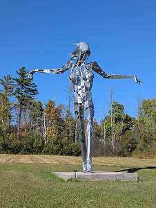 SVAC sculpture gardenInstead we drove as far as Killington, and then turned West of Route 4, stopping in the town of Rutland for what turned out to be a fabulous lunch at a place called Roots.
This lovely, elegant restaurant was tucked away in an alley, which we were only able to find by asking someone. I had a delicious Scallops Salad.
From there we continued west along 4, and then Route 30 back to Manchester.
 Cozy nightBefore going back to the hotel, we stopped at the Southern Vermont Art Center, set on a picturesque 100-plus-acre campus at the foot of the Taconic Mountains.
The SVAC features a variety of exhibition spaces as well as the largest sculpture park in Vermont. creating a unique fusion of art and nature.
By far my most favorite work was a statue of a horse covered with paintings by Leonardo da Vinci, Magritte, Van Gogh, Vermeer, Monet, Munch, Michelangelo, Degas, Klimt, and more.
That night back in our very cozy room at the Manchester View, Herb made a fire (real-wood not gas), and we cozied up with some wine.
Day 4 - Hike and wander around Manchester
 Lye Brook FallsRather than taking another long drive, we decided to hang out around Manchester for the day, starting off with a hike to Lye Brook Falls, a very popular hike to a waterfall, that begins at the end of the Lye Brook Access Road.
The trail starts off on a wide, flat path before entering a mixed hardwood forest. From there, we followed an old logging railroad before the trail began to gradually climb on much rockier terrain.
We crossed a few small streams and muddy places before coming to a fork where we took the one to the right, which led us on a spur trail to the falls. This section of the trail narrowed and hugged the side of a hill, with some interesting rock faces and running water.
 I found a red leaf!At 2.3 miles, we arrived at Lye Brook Falls, one of the highest waterfalls in Vermont, cascading approximately 125 feet down a series of tiers.
Before we started on the hike, Herb had looked to see if there were any Geocaches along the way, and found that there was one near the falls.
For those of you fellow travelers unfamiliar with geocaching, very briefly, it is an outdoor treasure-hunting game, in which people hunt for geocaches that have been hidden by someone. All these hidden caches can be found on the Geocaching app.
Participants, like us, then select a Geocache nearby to hunt for and then navigate to its GPS coordinates using a GPS device or smartphone with a geocaching app to navigate to the cache’s location. The Geocache App tells you how far away you are from the “treasure,” and when you walk, it tells you how many feet you are away from it. It also gives clues about where it is hidden.
 Colorful leaves in a streamThe geocaches themselves are waterproof containers (ranging from tiny little containers to ammo boxes) that contain little trinkets for trading—items that you would just throw away if you found them in your house, but for some reason feel like treasures after having gone through so much trouble trying to find them. I have a box of “treasures” I felt worthy of saving in my wall unit.
If you find it, as we did, you sign a logbook. If the cache contains small trinkets or "swag," you can trade items, taking something and leaving something of equal or greater value.
It might seem silly, but it’s a global phenomenon, with millions of geocaches hidden in over 190 countries.
Herb beat me to it this time
 Geocache successThen we retraced our steps back to the car for a total of 4.6 miles and 934 feet of elevation gain. It was a nice way to spend a morning.
Later that afternoon, we went back into Manchester and stopped in Orvis to look at fly fishing rods and the very well-stocked Northshire bookstore.
In the “Readers Park” on the outdoor patio of the bookstore, we came across a metal sculpture of Thomas Jefferson that brought back so many memories for us. It used to stand in front of the old Jelly Mill, a once cherished and iconic destination in Manchester, which was sort of a gift shop on steroids - a multi-level emporium housed in a sprawling, renovated dairy,barn, that you could get lost in for hours wondering through their eclectic array of goods.
.thumbnail.jpg) Thomas Jefferson statueI’m not sure who loved it more - my 80-year-old mother or my then 10 and 12-year old boys.
Thomas Jefferson statueI’m not sure who loved it more - my 80-year-old mother or my then 10 and 12-year old boys.
The point of my diversion is that the Thomas Jefferson statue outside the Northshire Bookstore used to stand in front of the old Jelly Mill.
On one hand, Jefferson holds a model of a church, and on the other, a government building. This is intended to represent the principle of the "balance of church and state," a concept deeply rooted in Jefferson's writings and political philosophy.
The rest of the statue continued some of Jefferson’s most famous quotations.
This was our last night in Manchester, so it was quite nostalgic to bring us all the way back some of our earlier visits when we used to come here with our young sons and my Mom and Dad.
Tomorrow, we would head to Shelburne Falls along the Mohawk Trail to spend the last night of our 2 ½ week East Coast vacation.
Day 5 - Hike to the Mount Olga fire tower in Molly Stark State Park and Shelburne Falls
 Setting off on the Mt. Olga TrailThis was it. The final day of what had been a fabulous 2 ½ week nostalgic trip back to some of our favorite spots on the East Coast, with the highlight being a full week with our sons, wives, and grandkids in a beautiful home on Edgartown Harbor on the island of Martha’s Vineyard.
Not that we had any choice, but we were pretty ready to get back home to Sonoma Valley, where we hoped to see the fall foliage colors of the grapevines in the wineries near our home.
But, this trip still had some fun things to do and places to visit.
 Climbint the Mr. Olga fire towerAfter leaving Manchester, we drove Route 30 to connect to Route 100, but this time, we went south rather than north. Then when we got to Route 9 (and scenic Vermont Road), we turned east to get to Molly Stark State Park, where we planned to do the highly acclaimed hike to the Mount Olga fire tower for panoramic views of the fall foliage below.
From the Visitor Center we set out on the trail which immediately led us through a beautiful forest of spruce and fir trees.
Already I liked this hike so much better than the previous day’s hike to Lye Brook Falls, because the terrain was less rocky and rooty, so I could actually look around me rather than constantly down at my feet so I didn’t trip.
 View from atop the fire towerWe took the loop in the recommended clockwise direction, which was steeper than the longer descent - not that either way was too steep with a total elevation gain for the hike was only 617 feet over 2.1 miles.
At 0.7 miles, we took the short spur trail to the summit of Mt. Olga, upon which the steel fire tower lookout tower sits. It was closed for repairs for a while, but fortunately for us, it was now open for climbing to the top.
 Top of the fire towerThe original purpose of this tower was to serve as a watchtower for spotting wildfires. It was staffed by a fire lookout, who would scan the surrounding landscape for any signs of smoke.
This method of fire detection was used until the 1970s, when modern technologies like aerial patrols and satellite imagery became more common for fire detection. So, today it’s purpose is purely recreational.
 What goes up, must come downWhen we arrived at the fire tower, there were two women waiting at the bottom waiting for their husbands to come back down, as they were not comfortable climbing up
As long as I can hold onto a railing, I have no problem, so Herb and I did not hesitate to make the climb to the top.
The climb consists of a series of metal stairs that wind their way up the interior of the tower's frame, with railing to hold onto along the way. Unlike some fire towers that can feel very exposed, the stairs on the Mt. Olga tower are enclosed by the steel framework, which provides a sense of security as you ascend.
 The Bridge of FlowersThe final flight of stairs led us through an opening in the floor of the 7’ x 7’ observation cab, where we were treated to a stunning and uninterrupted 360-degree panoramic view of the Berkshires of Massachusetts, the Green Mountains of Southern Vermont, and even Mount Monadock in New Hampshire.
Unfortunately, as I mentioned earlier, the foliage was a bit of a dud this year because of the dry weather and warm nights, but it still was very pretty.
 Bridge Street BridgeGoing down a fire tower is always a bit scarier than going up, but as long as we took it slow and held onto the railings, it was no problem.
To complete the loop, we headed back down the spur trail and continued on the main Mt. Olga Trail, which took us through the woods and into the park's campground area, completing the loop.
 Historic district from the Bridge of FlowersFrom there, we continued on to our final destination, Shelburne Falls, along the Mohawk Trail in Massachusetts.
Nestled in the rolling foothills of the Berkshires in Western Massachusetts, Shelburne Falls is a picturesque village, uniquely situated with the Deerfield River flowing through its center.
Where there are rivers, there are bridges to cross them, and Shelburne Falls has two of them, standing nearly side-by-side, each of which serves a distinct purpose.
 Reflections from the Bridge of FlowersThe Bridge of Flowers is Shelburne Fall’s most iconic landmark. Once a trolley bridge, in 1929 it was transformed into a stunning public garden creating a breathtaking floral walkway over the Deerfield River. From April to October, this 400-foot pedestrian bridge is adorned on either side with a vibrant and diverse array of flowers, vines, and shrubs, attracting visitors from around the world.
The Iron Bridge, also known as the Bridge Street Bridge is a truss bridge built in 1890. It runs parallel to the Bridge of Flowers and is the only way to get a car across the river.
 Reflections from the Bridge of FlowersThe first thing we did when we got to town was to stroll across the Bridge of Flowers, but it was so crowded with a tour group that we decided to try again later when we could at least get a decent photo of the flowers.
The other major attraction in the village is the glacial potholes, a collection of 50 smooth, circular pools carved into the metamorphic rock of the Deerfield riverbed, just below the falls.
These “potholes” range in size from 6 inches to 39 feet in diameter, which make it the largest of its kind in the world.
 Glacial PotholesDespite their name, the "glacial" potholes were not directly carved by glaciers. Instead, they are the result of a long and powerful process of river erosion that began around 14,000 years ago as the last glaciers retreated, creating a massive flood which produced a torrent of water carrying sediment (sand, pebbles, larger stones), which got trapped in small cracks and depressions in the riverbed. As the powerful current spun these trapped stones in a whirlpool-like motion, they carved out the smooth, deep, cylindrical potholes we see today.
Back when we were here in 2012, we were allowed to actually walk on and explore the potholes, but since then, for safety reasons, direct access to them has been restricted.
 Reflection under the Iron BridgeThe only way to view them now is from an observation deck at the end of Deerfield Avenue, just below the hydroelectric dam and Salmon Falls, just a short walk from the Bridge of Flowers.
So after lunch at the nearby Salmon Falls Cafe, we had to satisfy ourselves by gazing down at them from the observation deck.
It was just after 3 o’clock so we were able to check into our accommodations at the Blooming Inn, an historic 1852 Victorian house, which would be our home for the night.
 Blooming InnEach of the four rooms at the Inn are individually decorated, with antique furnishings as well as modern amenities like a private bathroom (although it was across the hall), Wi-Fi, A/C, etc.
We were in the 2nd floor Balcony Room, which I found out later was the most sought after room in the whole Inn, because it had a private balcony, which we did take advantage of that evening with a pre-dinner glass of wine.
While the Blooming Inn doesn't offer a traditional cooked breakfast like many Inns do, it has a very well-equipped self-serve coffee and tea station, along with toast, English muffins, and various spreads in a downstairs dining area.
.thumbnail.jpg) The Blooming Inn parlorI felt like we had stepped back in time. The village itself is a designated historic district, with well-preserved 19th-century architecture that gives it a timeless New England charm.
The Blooming Inn parlorI felt like we had stepped back in time. The village itself is a designated historic district, with well-preserved 19th-century architecture that gives it a timeless New England charm.
After our wine on our coveted balcony, we took a stroll through the historic district, with its well-preserved 19th-century architecture that gives it a timeless New England charm.
 A toast to an awesome vacationOur dinner reservation at the West End Pub was on the other side of the river, so we walked once more across the Bridge of Flowers. What a different experience it was than this afternoon when we were shoulder to shoulder with a tour group. We pretty much had the bridge to ourselves and the lighting was perfect.
After taking a few photos, I noticed that Herb was shooting down at the River itself, capturing the reflections of the historic buildings along the shoreline.
Ahh..Now that was even more interesting than the shots of the real thing.
That evening we had a wonderful dinner at the West End Pub, known for its cozy and upscale pub atmosphere, delicious food, and stunning views of the Deerfield River and the Bridge of Flowers.
What a great way to end a fabulous 40th Anniversary trip!
Edgartown
Sunday, September 21, 2025 - 1:30pm by Lolo0 miles and 0 hours from our last stop - 7 night stay
Travelogue
Day 1 - Kids arrival on the Ferry, Oak Bluffs stroll, Lunch at Nomans, Fun at the House, Stroll around Edgartown and Ice Cream
 Our home on the harborThe day we had been looking forward to for over 9 months, when Herb and I decided that we wanted to spend our wedding anniversary in the place where we had gotten married 40 years ago, had finally arrived.
We were married here way before Martha’s Vineyard became “the” place to get married.” The planning for our wedding was quite easy, and mostly done by phone - the Federated Church for the service, the Navigator Restaurant (now the Atlantic) for the reception, and some random band and florist for the final touches.
 Meeting the kids in Oak BluffsNowadays, I am sure a Vineyard wedding requires years of planning, not the handful of phone calls I made a few months in advance. I bet it costs a lot more too.
So now, here we were back, to celebrate with a very special guest list - our two sons, their wives, and their children (aged 18 months and 14 months).
To celebratd, we had decided to go big with a beautiful home on Edgartown Harbor with a huge deck with incredible views of the Lighthouse and the Chappy Ferry.
As always, the unloading of cars and passengers from the ferry is a bit hectic, so we decided to meet at nearby Ocean Park - the lovely grassy park with the gazebo, so the kids could run free. And run free they did, chasing geese and wondering why they never caught one.
Although we had seen each other just two weeks before, it was a very enthusiastic reunion. Spirits were very high.
 Cottage CityWe had some time to spare since we couldn’t check in for another 5 hours, so we took a stroll to "Cottage City,”an historic district within Oak Bluffs that is famous for its charming and colorful "gingerbread cottages."
It’s actually not that easy to find. In fact, we had been coming to the island for about 15 years before we first discovered this tiny city within a city. My excuse is that it is fairly well hidden and easily missed. The secret is to go through an alley between the stores on the western side of Circuit Avenue into what is known as “The Campground.” It’s like you’ve entered a totally different world.
 Lunch at NomansThis community originated in the 1830s when Methodists began coming to the island to hold revivalist meetings. This was the period of the Second Great Awakening, a religious revival movement that preached personal salvation through highly emotional outdoor revival meetings.
Initially, attendees stayed in tents, but as the gatherings grew larger and larger each year, the tents were eventually replaced by these small, whimsical “Gingerbread Cottages,” with their fanciful bright colors and ornate moldings.

We all were getting hungry, so Tommy did some research as to a good place for kids. He hit the jackpot with Nomans, a casual restaurant along the way to Edgartown, with good food and a large lawn area for a place for the kids to run free. There was going to be lots of “running free” on this vacation.
Lunch is always followed by naptime (often for Herb and the little ones), so we stopped along State Beach (the narrow strip between Nantucket Sound and Sengekontacket Pond), put the two kids in their strollers and walked them on the bike path until they fell asleep.
There was one more order of business before checking into the house - food shopping at the Edgartown Stop & Shop.
Three full shopping carts and nearly $800 later, we filled the cars to the brim with what we hoped would be most of our groceries for the week.
.thumbnail.jpg) Sunset from our deckAs we entered the house, we all pretty much gasped. From the pictures we all knew it was going to be beautiful, but this place was incredible, especially our views of the lighthouse and harbor right from our deck.
Sunset from our deckAs we entered the house, we all pretty much gasped. From the pictures we all knew it was going to be beautiful, but this place was incredible, especially our views of the lighthouse and harbor right from our deck.
The gang enthusiastically approved of our choice.
That night, as we would on most others, we stayed in for dinner, which is much easier with the kids. Plus we had the best views in town.
Day 2 - Fun at the House, Lighthouse Beach, Cocktail Hour, Kids go out on the town after the babies go to sleep
 "Out-doo" to visit their bird friendOur first morning in the house started pretty much as every morning would. Herb and I, whose bedroom was on the top floor with the kitchen and living room, would wake about 7:00 to the sound of two delightful little children quietly playing.
Eventually, I would hear Nora keep repeating “Amu,” which is her name for me - I guess her rendition of Grandma. Walker is several months younger and not quite as vocal yet, so Nora pretty much did the talking for him.
Then, before I was even able to finish my coffee, Nora grabbed my hand and said “Out-doo,” which meant that she wanted to go outdoors onto the deck, and of course “Baby,” her name for little Walker, had to come too.
So I would scoop the two of them up and we would go “out-doo,” first to say hello to the large seagull, sitting atop the chimney next door. She must have had a nest up there, because she greeted us every morning.
 Bubbles on the deckThen the two of them would excitedly point at all the action going on below - the marina pulling boats out of the water for the season with big machinery, the Chappy Ferry going back and forth from the wharf, people fishing on the dock, and, of course, the lighthouse beyond.
It was like watching an episode of Busy Town.
I had to practically drag them inside to have breakfast.
 Off to Lighthouse BeachOne of the best, of many, qualities of this house was location, location, location.
We could walk everywhere we needed to go in Edgartown - coffee shops, restaurants, cocktail bars, 3 ice cream shops, the lighthouse, etc.
After the kids (and Herb) napped, the boys loaded Nora and Walker into their backpacks and we all walked the short distance to the beach by the Edgartown Lighthouse, where the kids got a chance to play in the sand and splash in the water.
.thumbnail.jpg) Fun at the Lighthouse BeahAgainst everyone’s advice I had bought collapsible pails and shovels, and some little trucks and animal figures, and squeezed them into my checked bag. I’m glad I ignored their telling me this wasn’t necessary, because the kids had a blast.
Fun at the Lighthouse BeahAgainst everyone’s advice I had bought collapsible pails and shovels, and some little trucks and animal figures, and squeezed them into my checked bag. I’m glad I ignored their telling me this wasn’t necessary, because the kids had a blast.
I also packed a pinky ball, so the bigger kids (our two sons) also had a blast playing our old family game of running bases. They never seem to recognize the fact that I am approaching 70 and insist on me being the first one to run back and forth between the bases in deep sand.
.thumbnail.jpg) Fun at Lighthouse BeachI was still pretty fast, if I must say so myself, but Andrew said he noticed some deterioration in my pinky ball skills.
Fun at Lighthouse BeachI was still pretty fast, if I must say so myself, but Andrew said he noticed some deterioration in my pinky ball skills.
That evening we divided tasks between kitchen duty and playing with the kids in the downstairs sitting room, which too had beautiful views outside the window.
Tommy, Herb, and I were on kid duty, so we brought down some cheese and crackers, hummus, and drinks.
 Cocktail hour chaosThe scene soon descended into chaos with Nora climbing up on the little table by the window, Walker stuffing his face with cheese and crackers non-stop while using his fingers to make scratch marks in the cheese, Nora dipping crackers into the hummus before switching over to using her fingers and eventually a little toy truck to dip with.
We made sure to move all the obviously expensive decorative objects and books high up on the shelves out of reach of the kids, with the exception of two wooden fish (one about 12 inches long and the other about 6) which we made the mistake of showing them.

They carried those fish around constantly until Tommy googled them and found they were expensive antique heirlooms.
 Cocktail hour chaosThat’s when we hid them away when they went to bed, and I replaced them with plastic sharks from the Edgartown Paper Store the next day. After all, it was the 50th Anniversary of Jaws, which was filmed on Martha’s Vineyard.
After Nora and Walker were bathed and put to bed, Herb and I let the parents go out on the town for cocktails and/or ice cream. They lead such busy lives with few opportunities to just go out as adults so they very much relished these evening adventures.
Suffice it to say, everyone was having a great time.
Day 3 - Lunch at the Sea Food Shanty, Memorial Wharf, Playground
When Andrew, Tommy, Celeste, and Erin got back from their run, Herb and I took our turn and went for a 4-mile run around town and out along the bike path towards South Beach.
 The Sea Shanty LobsterDeciding that eating lunch out with the kids was easier than dinner, we went to the Sea Food Shanty, a very popular place just a short walk from our house. It was extremely busy, but the service was quick, and the food was good.
Afterwards we walked to one of our old favorite spots - the Memorial Wharf, atop from which you can look out over the harbor and watch the boats return from a day of fishing and the ever-faithful and ever-running On-Time Ferry, as it makes its way back and forth across the short distance to Chappaquiddick.
 From atop Memorial WharfWhen you get tired of looking out at the harbor, which is hard to do, you can just turn around and look out over the quaint and picturesque houses and shops of Edgartown. There is no bad direction to look.
Hey, wait a minute! This is the same view we get from our deck!!
However, the one view we couldn’t get from our house was a view of the house itself, so we made sure to take a photo.
 Playground TreatAfter the kids’ naps, we decided they deserved some playground time, so we loaded them in their strollers and walked about a mile to the Edgartown school on Robinson Street where they could run around and burn off some energy.
The kids were having a blast until one of them got pretty hurt - not the little ones, but our son Andrew had a pinky ball injury. Andrew and Tommy have always been very athletic and very playful, so they couldn’t resist throwing the pinky ball high and far to make the other one run for it.
.thumbnail.jpg) Sunset from our deckWell, in this case, Andrew was running back and didn’t see the bench behind him so he smacked his knee really hard into it and did a flip over the bench.
Sunset from our deckWell, in this case, Andrew was running back and didn’t see the bench behind him so he smacked his knee really hard into it and did a flip over the bench.
He just sat there stunned, so we knew he was pretty hurt. His knee was quite bruised making it hard for him to walk, so Herb and I ran back to get the car so we could drive him home. We immediately put ice on it and he took some Ibuprofen.
We kind of thought his mobility for the trip would be severely hampered, but he rallied enough to walk out after the kids were in bed to another cocktail venue.
Day 4 - Rainy, cozy day fun
 Rainy Day FortWe awoke the next morning not only to the pitter patter of little feet scampering outside our room, but to the pitter patter of rain on our roof. Ah yes, the first of two days of light rain predicted for the island.
However, we were still greeted with big smiles from the little ones and a request to go “Out-doo.” So out-doo we went to say hello to our bird and look at the Chappy Ferry going back and forth.
A rainy day was actually kind of nice to just chill and hang out in the house. We played some cards, made a fort out of the lounge chair cushions, took turns going out for runs, Herb fished from our dock, and in between the rain drops we took the kids out in the strollers for a walk around town.
It's funny how such a small island can have such a variety of distinctive histories and personalities - Aquinnah has it Native American roots, Oak Bluffs its religious revivalist meetings, and Edgartown its whaling.
Edgartown’s location on a perfect harbor helped it become one of the primary ports for the whaling industry during the 1800s, and more than 100 Edgartown men were captains of whaling ships.
.thumbnail.JPG)
The thriving whaling industry came to an end in the late 1800s when oil and kerosene began replacing the need for whale oil.
Today, Edgartown’s source of livelihood is tourism, as thousands of mainlanders invade the island each summer to enjoy its unique history, charm, and beauty.

When the rain slowed down, we ventured out with the kids in the strollers and stopped in the Edgartown bookstore, where I bought the kids a child version of Jaws, which managed to skip all the parts about eating people. However, it had the words “Bam Bam Bam Bam” next to any picture of the shark.
 Walker's plastic sharkIt went very well with the little plastic sharks I had bought them the previous day. Very Appropriate for the 50th anniversary of the filming of jaws. Nora began calling the book “Bam Bam Bam Bam,” which was quite cute. If she only knew what really happened after each “Bam Bam Bam Bam.”
As evening came around, Nora and Walker anxiously awaited for cocktail hour where they knew they could fondle cheese and dip various objects in the hummus.
All in all, a fun, somewhat relaxing day was had by all.
Day 5 - Menemsha, Kids go to Bad Martha Farmers Brewery and Pizzeria, Herb and I go to Atlantic Fish & Chop House
We knew today was going to be another rainy day, but nothing bad enough to keep us from getting out and about.
.thumbnail.jpg) Menemsha Fishing ShackToday, we decided to go to Menemsha, one of my favorite places on the island, and one where we have spent many wonderful times. Andrew and Tommy have many fond memories of this village and were the driving force to revisit it, despite the rain.
Menemsha Fishing ShackToday, we decided to go to Menemsha, one of my favorite places on the island, and one where we have spent many wonderful times. Andrew and Tommy have many fond memories of this village and were the driving force to revisit it, despite the rain.
As I mentioned earlier, each of the towns on the island have their different histories and personalities. This one is a genuine, hard core fishing village that has hardly changed in the 30 years we have visited it. It is so picture postcard perfect that it seems more fake than real.
 Walker enjoying the sandIn fact, it was used as a stage set during the filming of the movie Jaws, so it was very appropriate that we were visiting it on the movie’s 50th anniversary. We should have brought the kids’ Jaws book for a reading. “ Bam Bam Bam Bam.”
It has a lovely little beach near the jetty, where the kids delightfully played with their pails and shovels for an entire hour without eating any sand.
.thumbnail.JPG)
 Menemsha JettyWith a little encouragement, Herb got his fishing rod out and cast a few from the beach. Unfortunately, no one was having too much luck, even though the Annual Fishing Derby was in full swing. The word was that the fish just weren’t coming in yet.
Since nothing much was going on in terms of fish on the jetty, we started reminiscing about past times here. This particular story is very appropriate for our wedding anniversary in that it raises the question of what saw in me as a bride.
was not exactly a very good cook then – not that I am that great now – but I was particularly inexperienced at the time.
I did not understand the concept of how much rice expands when you cook it. Before I knew it, I had enough rice to feed a family of 10 and it was bubbling over the pot onto the jetty. I think that is when Herb realized he wanted to marry me. Somebody had to do it and it’s lasted 40 years.
 Lunch at The GalleyOK. Fast forward 40+ years back to the present.
Done with the playing in the sand and fishing portion of the day, we strolled along Dutcher Dock, past the weather-beaten fishing boats and fresh seafood markets to The Galley, a family owned business that has been around for 76 years serving their famous lobster rolls and chowder.
The food was great but the clientele was a bit rambunctious.
Back at the house, pretty much everyone napped and then got ready for our independent dinner plans.
 Our romantic dinnerAndrew, Celeste, Tommy, Erin, Nora and Walker went to Bad Martha Farmer’s Brewery and Pizzeria, known for its great pizza and beer, and kid-friendly atmosphere with games and live music, making it a fun place to relax and hang out. The kids had a great time coloring, and the adults had a great time watching them have fun together while they drank beer.
 Our romantic dinnerMeanwhile, Herb and I went out for our Anniversary to the Atlantic Fish & Chop House, which used to be the Navigator Restaurant where we had our wedding reception.
It was very much different in decor and pretty much everything else, but we had a fantastic meal in a lovely setting.
I had the Black Truffle Lobster Mac & Cheese, which was to die for and very reasonably priced in a restaurant that had a $220 steak entree.
Poor Herb had a little more trouble ordering because of his shellfish allergy. His first choice was an Osso Bucco but that was a no no because it was potentially contaminated with cooking oils and utensils exposed to shellfish.
 Post-dinner view from atop the WharfAfter going through a few more selections from the menu, the waiter finally said that the Roasted Mediterranean Chicken had no risk of contamination. Fortunately, Herb said it was delicious.
When we got back to the house, the babies were sleeping but the parents were still up, so we spent a lovely hour sipping red wine with our adult children and their wives.
I never wanted this moment to end. I was overwhelmed with happiness and joy just looking at the family our marriage had produced. We couldn’t have been any more proud of the sons we had produced, the beautiful wives they had smartly selected, and the two most adorable grandchildren any grandparent could ask for.
Day 6 - Bike Rental, Ride and Play on State Beach, Lunch at the Quarter Deck, and Nomans for Oktoberfest
.thumbnail.JPG)
 Walker's first time with a bike helmetOften our bicycle trips to town did not end in Edgartown. Charged up on muffins from the now defunct Mrs. Miller’s Muffins, we would ride our bikes onto the Chappy Ferry and peddle out to Dike Bridge or Wasque (see Chappaquiddick) – a pretty impressive distance for kids on heavy Toys R Us bikes.
There were many vacations where they would put as much as 100 miles on their odometers.
Wanting to give their children the experience of biking the island (although they would be passive passengers on back), we headed over to Wheel Happy Bike Rentals to rent 6 bikes, 2 with child seats.
.thumbnail.jpg) Fun at State BeachNora, who lives in San Francisco, is a veteran bike passenger and gets extremely excited just at the mention of the word “bike,” and yells “Wee-oh-wee” to every passerby during every ride.
Fun at State BeachNora, who lives in San Francisco, is a veteran bike passenger and gets extremely excited just at the mention of the word “bike,” and yells “Wee-oh-wee” to every passerby during every ride.
Walker, however, has never had the pleasure of riding behind daddy, so this was going to be a very new experience for him. Being the little adventurous baby he is, we thought he would love it.
 Fun at State BeachThat dream ended the moment Andrew placed a helmet on his head and he began to scream and try to pull it off.
Thinking he would stop crying once we got going, we set out towards State Beach along Beach Road on the way to Oak Bluffs, which Herb and I had scouted out yesterday as a good beach for kids.
That felt like the longest 3 miles I have ever ridden. Poor little Walker cried and kept pulling his helmet down over his face to make this all go away.
 Fun at State BeachFinally, he just passed out and we could see his little head slumped over to the side. Meanwhile, Nora was still yelling “Wee.”
Fortunately, Walker was much happier when we got to the beach, and the kids spent a delightful couple of hours digging in the sand and splashing near the water’s edge.
There was more “pinky ball” running bases played where I was once again made to pretend I was 20 years younger and run as fast as I could between the bases.
.thumbnail.jpg) Lunch on the WharfWhen it was time to get back on the bikes to ride home, Walker once again resisted the helmet and cried all the way back. I felt so bad for him and wondered how we were going to possibly be able to take him out for our proposed ride to South Beach tomorrow.
Lunch on the WharfWhen it was time to get back on the bikes to ride home, Walker once again resisted the helmet and cried all the way back. I felt so bad for him and wondered how we were going to possibly be able to take him out for our proposed ride to South Beach tomorrow.
He cheered up a bit when we stopped at the Quarterdeck for lunch on the Wharf. Walker very much loves to eat and was very happy with his grilled cheese sandwich.
.thumbnail.jpg) Keg ThrowingWhile the kids were napping, Andrew and I decided to take a nostalgic 10-mile bike ride to South Beach. Wow! The beach has eroded significantly since we used to come and was much narrower. Still, we decided it would be a good place to bike ride with the kids tomorrow.
Keg ThrowingWhile the kids were napping, Andrew and I decided to take a nostalgic 10-mile bike ride to South Beach. Wow! The beach has eroded significantly since we used to come and was much narrower. Still, we decided it would be a good place to bike ride with the kids tomorrow.
Still concerned with Walker’s obvious disdain for his helmet, I decided to walk over to Wheel Happy to see if I could get a smaller helmet for him, which I did. It also had a lot fewer plastic straps which I think was irritating his ears. When we placed this helmet on his head, he did not resist, but rather smiled and started patting it like Nora does when she wants to go for a ride. Whew! That was a relief.
.thumbnail.jpg) Pretzel TossingTonight was the night of the big Oktoberfest at Nomans in Oak Bluffs, so we loaded the kids up in the car and headed over for some Bavarian food, craft beers, live music, and games.
Pretzel TossingTonight was the night of the big Oktoberfest at Nomans in Oak Bluffs, so we loaded the kids up in the car and headed over for some Bavarian food, craft beers, live music, and games.
This event was first held 2 years ago, but it was such a hit that it has become an annual event, in which they transform their spacious outdoor patio and lawn into a festive German-inspired beer garden with classic Bavarian fare, live music, and festive games and contests.
.thumbnail.jpg) Nora fliesAndrew, Tommy, Herb, and I participated in the Keg Throwing competition, in which we each competed to see who could throw a beer keg the furthest.
Nora fliesAndrew, Tommy, Herb, and I participated in the Keg Throwing competition, in which we each competed to see who could throw a beer keg the furthest.
Fortunately, the women’s beer keg was smaller, so Herb and I actually got the same 10-foot distance. I think people were just impressed that Herb and I, obviously the oldest in the competition, were out there trying. I think we did pretty well considering.
 Walker boogying to musicMe, Tommy, and Nora did the pretzel toss, where Tommy held a toilet plunger on top of his head, and we tried to land a pretzel on it.
Nora preferred just walking away and eating her pretzel. Smart girl.
The music was lively and fun.
Walker demonstrated his moves, which were quite impressive for a 14-month old, while Erin and Nora jumped onto the dance floor and did the “electric slide”
We all had a blast.
Day 7 - Bike Ride and Play on South Beach and enjoying the wedding next door
 Walker not very happy about his helmetI can’t believe it’s our last day. It all went so fast.
We still had the bikes for another day, so we decided that since we had already taken the kids to Edgartown Lighthouse Beach and State Beach, which are both located on the calm waters of Nantucket Sound, today we would show them some Atlantic Ocean waves on South Beach.
 The gang at South BeachFortunately Walker seemed much happier with his smaller helmet, and even asked us to put it on his head by tapping his fist to the top of his head like Nora does when she wants to go for a bike ride.
Thank goodness, because today would be a longer 10-mile ride in total, rather than the shorter 5-mile trip to State Beach yesterday.
Maybe we would even get him to yell “Wee-oh-Wee.”
We set off through town and out along the bike path along Katama Road. For old time sake, we took the longer route to the beach along the Edgartown Bay Road, where we had rented a house in the past. Boy, did this bring back great memories.
 South Beach FunIt was so much more fun biking when the littlest one in the group was joining in the joy of a morning bike ride to the beach.
As a family, we had been to South Beach many many times over our decades of vacationing here, so that’s why we were dismayed to see how much it had changed. It was still a beautiful beach, but for those that had seen it in its prime, it was a bit sad.
 South Beach FunOver the last decade, South Beach has undergone significant changes, primarily driven by accelerating erosion from more frequent and intense storms. This has led to a noticeable narrowing of the beach.
The winter of 2023-2024 proved to be particularly damaging. A series of powerful storms carved away large portions of the dunes, leading to the collapse of a section of Atlantic Drive and forcing the removal of the iconic lifeguard shack.
_0.thumbnail.jpg) South Beach FunOnce one of the widest beaches on the island, South Beach has become one of the narrowest. Some longtime residents recall the beach extending hundreds of feet further out than it does today. The rate of erosion on the south shore of Edgartown now exceeds 10 feet per year.
South Beach FunOnce one of the widest beaches on the island, South Beach has become one of the narrowest. Some longtime residents recall the beach extending hundreds of feet further out than it does today. The rate of erosion on the south shore of Edgartown now exceeds 10 feet per year.
In addition to the narrowing of the beach, we noticed that there were a lot more shrubs and woody vegetation in the backdune areas where there used to only be beach grass.
 South Beach FunAs far as the kids were concerned though, the beach was perfect - plenty of soft sand to dig and play in and a gentle surf to wash over their toes.
The big kids had fun as well playing in the surf.
After an hour or two, we hopped back on our bikes, but instead of going back the way we came, we rode parallel to the beach along Atlantic Drive and then made a right onto Herring Cove Road.
.thumbnail.jpg) Happy FamilyRight after Herring Cove Road joined Katama Road, we stopped at the Katama General Store for lunch, which is something I have always wanted to do, but for some reason never had.
Happy FamilyRight after Herring Cove Road joined Katama Road, we stopped at the Katama General Store for lunch, which is something I have always wanted to do, but for some reason never had.
Not sure why we waited so long! There was a great selection of sandwiches and a lovely wrap-around porch to have lunch on. It was great!
Herb and I realized that we didn’t have a good family photo for our 2025 Christmas card yet, so that afternoon after naps, we lined up "out-doo" on our beautiful deck and Herb set the tripod up so he could click away on his remote.
He literally took about 100 photos, as it is always difficult to get a good expression on everyone’s face, especially me. I think he nailed it.
.thumbnail.JPG)
The only place to get a great view of this obviously spectacular wedding was from our ground-level patio.
We hadn’t spent any time as of yet on the lower patio and dock of our house because there was no guard rail or fence between the patio and the water to keep Nora and Walker from taking an unplanned swim.
.thumbnail.JPG)
Of course, everyone made fun of me and said they were ridiculous, but I got the last laugh, as everyone immediately realized that there was no way we could vicariously attend this wedding from our patio unless the kids were in some way constrained and under our constant control.

It was a bit chaotic, to say the least, but Nora and Walker's enthusiasm and antics added much to the fun.
We were so close that we felt more like wedding guests than the voyeurs we were. Ever since we had watched the huge tent go up a few days ago, we had been anxiously anticipating this event.
 Enjoying the weddingIt was quite the shindig, a lot more opulent, and I am sure literally 100 times more expensive than our humble little wedding 40 years ago.
There was a live band that played for hours and they were really good.
We let Walker and Nora stay up later than their normal bed time, but it was still hard pulling them away to go to bed.
After they were asleep, we stayed up with the bigger kids sipping red wine and feeling quite content about our week together on this magical island.
It was a perfect celebratory end to what had been an absolutely fantastic family vacation.
Aquinnah
Wednesday, September 17, 2025 - 3:45pm by Lolo0 miles and 0 hours from our last stop - 4 night stay
Travelogue
Day 1 - Arrival at our Airbnb in Aquinnah and Lobsterville Beach
 Our Aquinnah AirbnbAfter flying into Boston and spending our first night in Falmouth, we took the ferry the next morning from Woods Hole to Oak Bluffs. Boy! Did this bring back memories, from trips in our 20’s, through our wedding in Edgartown, and then with our sons for another 20 years.
The kids weren’t arriving for another 5 days, so Herb and I would spend some time alone in an Airbnb in the town of Aquinnah, located on the western end of Martha’s Vineyard (referred to as “up-island”), bordered by the Vineyard sound to the north and the Atlantic Ocean to the west and south.
 Herb fishing on Lobsterville JettyIt is home to a year round population of 311, half of which are members of the Wampanoag tribe.
We were very pleased with our Airbnb rental, a cozy and beautifully furnished Cape house, just a 3-minute walk to Lobsterville Beach, one of our old favorite spots to fish and watch the sunset, which is unique to do on the East Coast, but this beach faces west.
After settling in, despite the light rain, we drove the short distance to Lobsterville Beach, so Herb could cast into the Atlantic Ocean for the first time in over a decade. Unfortunately, the fish were unimpressed, but still it was nice to see him standing on the jetty, rod in hand, once again.
Day 2- Run, Lone Star Tick Bomb, and Menemsha
 Our lovely AirbnbThe next morning we decided to go for a 5-mile run to the Aquinnah lighthouse, the official name for what we once knew as the Gay Head lighthouse. The name change happened in 1997 when the town of Gay Head officially reverted to its original Wampanoag name, Aquinnah (pronounced ah-KWIN-ah), which means "land under the hill."
Being somewhat paranoid, to say the least, about the lone star ticks prevalent on this part of the island, I kept nagging Herb to stay away from any vegetation that came too close to the road we were running along.
 Our lovely AirbnbAfter running for about 2.3 miles we came to the path to the Lighthouse, where I carefully stayed away from any lurking lone star ticks waiting to jump on me.
Set atop the stunning Gay Head (or is it Aquinnah?) cliffs, this lighthouse was opened in 1799 to guide ships through the treacherous waters between the Gay Head Cliffs and the Elizabeth Islands. In 2015 it was moved back 129 feet from the edge of the eroding bluff to its current location.
 Aquinnah Lighthouse and CliffsThe historic move took place over three days, during which the entire 400-ton brick and mortar structure was painstakingly lifted and slid along steel beams to its new foundation, 129 feet away from its original location. The relocation was a massive community effort and a significant engineering achievement, undertaken to save the iconic 1856 lighthouse from tumbling into the sea due to the rapidly eroding Gay Head Cliffs.
 Aquinnah LighthouseFrom there we continued our run around the tip of Aquinnah to continue our run along State Road back to the house. A tiny little piece of vegetation that was sticking out into the road brushed my leg and I kiddingly said to Herb, “Oh no, vegetation touched me.”
We continued on for a bit, until I stopped to scratch my left (vegetation-side) leg, which was starting to itch. To my horror, the side of my left calf looked like it had been sprinkled with pepper. I yelled ahead to Herb that I think I might have ticks on my leg, but he didn’t hear me.
 MenemshaUnsure what to do, I brushed them off my leg. One still remained, so I scratched him (or her?) off. Then I scratched the whole area thoroughly, which began to bleed from each of the little red spots where they tried to violate me.
I finally caught up to Herb and told him what happened. I admit to being in a bit of a panic. Somewhat fortuitously, we came upon the Aquinnah town hall and actually found the office for the health administrator inside. She looked at my leg and said that it looked like I had been the victim of a "tick bomb," but got them off in time, so that made me relax a little bit. We also bought 6 permethrin treated socks for $1 each to wear as a precaution if necessary.
 MenemshaBack at the house, I immediately took a hot shower and then Herb used his magnifying glass and tweezer to try to pull out anything that might be in my leg. He pulled on what looked like tiny little strands from my leg and when we looked at them closely, they appeared to have a bulbous head. OMG, I thought - that's disgusting and horrifying.
 Menemsha Fishing Shack DoorAfter the tick trauma, we decided to take a ride to one of our favorite places - Menemsha, a quaint little fishing village so picture postcard perfect that it seems more fake than real. In fact, it was used as a stage set during the filming of the movie Jaws.
Menemsha Village lies on the eastern shore of Menemsha Pond where it flows out into Vineyard Sound. On either side of the channel out to the Sound, there are rock jetties, very popular for surfcasting.
Before heading to the jetty, we walked out on Boathouse Road. I went ahead of Herb to take pictures while he stayed behind to talk to a Wampanoag boat captain. Herb loves to talk about fishing, but he developed a new love for talking about ticks and what had happened to me earlier this morning.
He told us we needed to get to a pharmacy to get permethrin cream, which would kill any remaining ticks that might have embedded in my leg. It is most effective if applied within 24 hours of the bites.
So rather than strolling on the jetty, we spent the next 4 hours trying to get my health insurance company to call in a prescription to a pharmacy in Edgartown, a half hour away. Unfortunately, they did not respond in time for me to get it that day.
Day 3 - Chilmark General Store and Moshup Beach
 Chilmark General StoreWhen we woke up the next morning, I thought we would be spending another day wasting time trying to get the permethrin cream prescription.
However, after discussing my situation, Herb and I came to the same conclusion, that the miniscule bulbous headed threads he had pulled out of my leg with a tweezer yesterday were not in fact ticks, but rather nubs with the hair follicle on the end. We felt like idiots.
We still were convinced that I had been the victim of a “tick bomb,” but were pretty confident that I had gotten them off in time.
 Strolling Moshup BeachSo, today we would go to beautiful Moshup Beach and not worry about ticks for the day.
But first a quick stop at the Chilmark General Store to pick up sandwiches. I love this store. Besides having a great selection of sandwiches and prepared foods, they have a lovely covered porch with rocking chairs to sit on and talk about the Vineyard news of the day.
 Moshup BeachI felt so confident that my tick situation was under control that we bought meatball parmesan to have with pasta tonight. Take that alpha-gal meat allergy syndrome.
Then it was on to Moshup Beach, a beach so stunningly beautiful that the Travel Channel selected it as one of the top 10 beaches in the country.
The beach lies at the base of the 130-foot high stunningly beautiful and multicolored Gay Head cliffs, named for its “gay” brightly colored red, brown, yellow, and tan striations.
 Back for sunsetIn many parts of the beach, rivulets of red clay seep out of the cliffs and flow towards the ocean. In the 1960’s and 70’s this became a popular spot for nude sunbathers to partake in “clay baths.” Today that is no longer allowed. However, there is still a section of the beach that is clothing optional.
Well, so much for not talking about ticks today. Herb has found a new way to make friends, as everyone on the island wants to talk about these stupid lone star ticks.
 Sunset at Moshup Beachveryone had something to say about my situation, but the final consensus was that I got them off in time and would live a long life filled with happiness and meat.
We spent a couple of hours soaking up the sun on this seasonably warm Vineyard day, enjoying some very entertaining conversation with our new friends.
 Sunset at Moshup BeachThe colors of the cliff are best photographed at sunset so we went back to the house for a few hours before returning once more to this truly lovely spot.
The cliffs did not disappoint, but put on a spectacular show making their layers of red, yellow, and orange appear even more vibrant.
Back at the house I ate my meatball parmesan with impunity.
Day 4 - Menemsha and Moshup Beach for Sunset
 MenemshaSince our visit to Menemsha was cut short 2 days ago because of our panic over getting a permethrin prescription, we decided to go back.
Menemsha is one of my favorite places on the island, and one where we have spent many wonderful times.
Over the years, we have done a lot of fishing from the Menemsha rock jetty, which is usually pretty crowded with fishermen trying to land a blue or striper. We have had our fair share of success over the years with many a fish at the end of our lines. Unfortunately, stripers have become so scarce that they are no longer included in the annual fishing derby.
 Menemsha JettyWith a little encouragement, Herb got his fishing rod out and joined the other fishermen on the jetty. Unfortunately, no one was having too much luck, even though the Annual Fishing Derby was in full swing. The word was that the fish just weren’t coming in yet.
Since nothing much was going on in terms of fish on the jetty, we started reminiscing about past times here.
 Moshup Beach at sunsetI remember coming to the Vineyard once in October before Herb and I were married. We came down to Menemsha to watch the sunset and do some fishing. We didn’t have much money then, so we were going to cook dinner on Herb’s camping stove on the jetty.
I was not exactly a very good cook then – not that I am that great now – but I was particularly inexperienced at the time.
 Moshup Beach at sunsetI did not understand the concept of how much rice expands when you cook it. Before I knew it, I had enough rice to feed a family of 10 and it was bubbling over the pot onto the jetty. I think that is when Herb realized he wanted to marry me. Somebody had to do it and it’s lasted 40 years.
Done with the fishing portion of the day, we strolled along Dutcher Dock, past the weather-beaten fishing boats and fresh seafood markets.
 Moshup Beach at SunsetWe stopped for lunch at The Galley, where I had my first of many clam chowders of the trip.
After a nap back at our house, we headed out once more to Moshup Beach to photograph another beautiful sunset.
Then it was packing up for an early departure tomorrow morning to meet the kids at their ferry in Oak Bluffs to begin our week-long stay in Edgartown. Very very excited!.
Snow Canyon State Park
Sunday, June 1, 2025 - 5:45pm by Lolo264 miles and 4.5 hours from our last stop - 1 night stay
Travelogue
 Our campsiteMoonscape was our last planned stop on our Utah adventure, but since we had a 15-hour drive home, we decided to break it up, squeezing in one more place in Utah that we had never been to before - Snow Canyon State Park, another southwestern Utah red rock wonderland.
Located near the town of St. George, Snow Canyon boasts 7,400 of red and white Navajo sandstone cliffs and ancient black lava flows. Oh, and there’s even an ancient wind-blown sand dune that solidified into stone, called the petrified dunes.
.thumbnail.jpg) White Rocks AmphitheaterSounded great to us, and hardly off our route home, so off we went, hoping to discover a new Utah gem.
White Rocks AmphitheaterSounded great to us, and hardly off our route home, so off we went, hoping to discover a new Utah gem.
Fortunately when we arrived around 3 pm, there were still a few campsites available, and the ranger was nice enough to give us the very best one - site 27, a large private site set against the backdrop of the red cliffs.
It was a little too late to start a long hike, so we just drove north on the scenic drive through the park and out the north entrance to the trailhead for the short hike to the White Rocks Amphitheater.
 Snow Canyon OverlookFrom the trailhead we hiked down to the base of a rocky escarpment and then scrambled up and along slickrock, eventually finding ourselves standing in what looked like a large bowl or “amphitheater.”
Although the name might imply a man-made structure, this “amphitheater” is actually an example of a fossilized ancient sand dune, formed over 195 million years ago when layers and layers of sand were deposited here by ancient winds.
 Setting off on the Pinyon TrailGradually (in geological time), these accumulated sand layers became compacted and cemented together, undergoing a process called petrification, which transformed the loose sand into solid sandstone.
The beautiful swirling patterns that we were scampering over are the result of these ancient wind-blown sand layers, a geological feature known as "angular cross-bedding."
 Climbing up to Pinyon Canyon OverlookSo, why is this rock formation white, rather than red like all the other rock in Snow Canyon? The leading hypothesis is that the iron oxide that makes rock red was leached out of this particular rock formation by hot groundwater and heat generated from nearby volcanic eruptions that occurred more recently.
But nature didn’t stop there. Once the sandstone was formed, wind and water sculpted the rock over millions of more years, carving out the “bowl” or “amphitheater” shape that we were standing in today.
 Atop the Hidden Pinyon OverlookIt was a nice contrast to the predominantly red rock landscape we had been traveling through all week.
Before returning to the campground, we drove a little further down the road outside the park to an overlook that provided an expansive view down into the main Canyon - a wonderland of red rock to explore tomorrow morning.
Then it was back to our campsite to relax in our own private little red rock surroundings where Herb made our go-to Mountain House Pad Thai.
 View from Hidden Pinyon OverlookThe next morning we set out pretty early on the Hidden Pinyon Trail, which conveniently began right across the road from our campground.
It’s a self-guided nature trail, with marked numbered posts that correspond to a brochure that describes the geology and the flora near each post. I’m a bit embarrassed to admit that we ignored the brochure and charged on.
The trail was quite lovely, winding through rocky passages, across sandy stretches, and through small canyons filled with pinyon pines, creosote bushes, and cacti.
 Hiking up the Petrified DunesA little less than a mile into our hike, we hung a left onto the spur trail to the Hidden Pinyon Overlook. The trail led us into a “hidden canyon” area and then a rock scramble up to the top of a bluff from which we were treated to sweeping panoramic views of the Snow Canyon.
Because of the cloud cover, which had made for comfortable hiking temperatures, the usually vibrant red rock was muted in a softer light, more of a salmon color, which we actually found quite lovely. It’s amazing how light can make such a difference in the appearance of these rocks.
 The Petrified DunesOnce back on the main Hidden Pinyon Trail, we soon connected with the Red Sands Trail, named for its stretches of vibrant red sand.
At about 1.5 miles into our hike, we arrived at the Petrified Dunes, another fossilized ancient sand dune like the White Rocks Amphitheater we had hiked to last night.
They were formed in a similar fashion, but unlike the White Rock Amphitheater, the iron oxide had not been leached out of the Navajo Sandstone of this one, so it retained its salmon to reddish color.
 Bye bye Snow CanyonThe beautiful swirling patterns in the rock are the result of these ancient wind-blown sand layers, a geological feature known as "angular cross-bedding."
There was no defined trail up the dune. Instead of cairns, we followed what looked like helmets with arrows on them to mark the direction to get to the top.
It was hard to believe that this was once a sand dune. Have I mentioned that Mother Nature is pretty amazing?
Once over the dune, we walked back to the campground on the paved Whiptail trail, which traced the park’s scenic drive.
Snow Canyon had far exceeded expectations.
Mars Desert Research Station, Factory Butte, and Moonscape Overlook
Saturday, May 31, 2025 - 4:00pm by Lolo100 miles and 3 hours from our last stop - 1 night stay
Travelogue
Mars Desert Research Station
.thumbnail.jpg) Mars Desert Research StationAfter our lunch at Duke’s Slickrock Grill in Hanksville (population 170), we headed back west on Ut-24 for 3 miles and then made a left onto Cow Dung Road towards the Mars Desert Research Station (MDRS). From there we drove about 4 miles through the incredible red and white bentonite hills before coming to the Mars Desert Research Station.
Mars Desert Research StationAfter our lunch at Duke’s Slickrock Grill in Hanksville (population 170), we headed back west on Ut-24 for 3 miles and then made a left onto Cow Dung Road towards the Mars Desert Research Station (MDRS). From there we drove about 4 miles through the incredible red and white bentonite hills before coming to the Mars Desert Research Station.
This area was chosen for the MDRS because of the Bentonite Hills and badlands striking resemblance to the surface of Mars. So much so that it was used as the setting of the fictional planet Vulcan in the 2009 film Star Trek.
.thumbnail.jpg) Feels like MarsLike Mars, the terrain is barren and rocky with minimal vegetation, featuring red and orange sandstone formations. It is otherworldly.
Feels like MarsLike Mars, the terrain is barren and rocky with minimal vegetation, featuring red and orange sandstone formations. It is otherworldly.
Built and managed by the Mars Society, the Mars Desert Research Station is one of only four simulated Mars habitats in the world being used to simulate the hardships and challenges that pioneers would face in a potential colonization of Mars.
Although not allowed on the grounds, we could see several of the buildings. The two-story, eight-meter cylindrical one is called the “Habitat,” also known as “Hab.”
.thumbnail.jpg) Annual University Rover ChallengeAstronauts and research crews spend two weeks at a time living in Hab. To most realistically simulate the Martian environment, they wear space suits and carry walkie talkies whenever they step outside Hab.
Annual University Rover ChallengeAstronauts and research crews spend two weeks at a time living in Hab. To most realistically simulate the Martian environment, they wear space suits and carry walkie talkies whenever they step outside Hab.
It would have been so cool to see astronauts wandering around the bentonite hills, but I later learned that they are only here from October to May. We must have just missed them.
Last time we visited, there was absolutely no one here, so we were quite confused as to why there were dozens of cars and hundreds of people. Well it turned out that we had stumbled upon the annual University Rover Challenge, the world's premier robotics competition for college students where teams design and build the next generation of Mars rovers that will one day work alongside astronauts exploring the Red Planet.
Factory Butte
 North Caineville MesaAfter the Mars Desert Research Station, our next plan was to drive by Factory Butte and then on towards the Moonscape Overlook to camp for the night.
Rather than take the shortest way to the east side of Factory Butte, we decided to drive around the entire Butte. So rather than turn right onto Factory Butte (Coal Mine) Road, we continued on to the town of Caineville and turned right onto the road that we came out of at the end of our Cathedral Valley Loop drive earlier today.
 North Caineville MesaWhen we came to a junction, rather than turn left to do the Cathedral Valley Loop again in reverse, we took a right to follow the North Caineville Reef to Factory Butte.
Factory Butte is a massive, 6,302-foot monolith that rises dramatically from the surrounding "lunar badlands."
Driving around it is interesting, because it actually looks quite different from different perspectives.
.thumbnail.jpg) One perspective of Factory ButteMormon settlers got here first, so they got the chance to name it. They thought it looked a bit like a large woolen mill (factory) back in Provo, so “Factory” Butte it became. They must have been homesick.
One perspective of Factory ButteMormon settlers got here first, so they got the chance to name it. They thought it looked a bit like a large woolen mill (factory) back in Provo, so “Factory” Butte it became. They must have been homesick.
Most others don’t think of a woolen mill when looking at this very impressive formation, but rather it is more often described as a cathedral or sand castle.
The ripples at the base of Factory Butte are what make it so photogenic.
These “ripples” are essentially layers of ancient mud and clay that have been exposed and sculpted by erosion over millions of years.
.thumbnail.jpg) Factory Butte and it's ripplesMillions of years ago, this area of Utah was covered by a vast, shallow inland sea, the bottom of which was covered with layers of mud and clay particles. Eventually these layers were compressed and cemented together to form a soft rock called Mancos Shale.
Factory Butte and it's ripplesMillions of years ago, this area of Utah was covered by a vast, shallow inland sea, the bottom of which was covered with layers of mud and clay particles. Eventually these layers were compressed and cemented together to form a soft rock called Mancos Shale.
This shale isn't a single color because it contains different minerals that give it varying shades.
.thumbnail.jpg) Sunrise on Factory ButteThe Mancos Shale is relatively soft, so it erodes more easily than the harder rock that forms the top of Factory Butte.
Sunrise on Factory ButteThe Mancos Shale is relatively soft, so it erodes more easily than the harder rock that forms the top of Factory Butte.
As the shale eroded, the different colors (greys, purples, oranges, and golds) within them became exposed.
Since erosion happens unevenly, it creates what looks like wavy, colorful ripples across the base of the butte.
I can’t say it enough, but nature is an incredible artist.
Moonscape Overlook
 Moonscape OverlookWhen we had gotten about three-quarters of the way around Factory Butte, we started looking on Gaia for the turnoff towards the Moonscape Overlook (also called Skyline Rim Overlook).
There are no signs on these roads indicating where anything is, so we had to rely on Google Maps and Gaia to get where we wanted to go.
We had been here two years ago, so we could follow our tracks on Gaia. Once making the turn, we drove for about 2 miles across a flat expanse, at the end of which we found ourselves perched on the edge of a cliff, looking out over an expanse of badlands, known as the Blue Valley, below us and the Henry Mountains in the distance. It was mind blowing.
 Moonscape OverlookThere was only one other camper van at the overlook, parked a bit away from the edge, so we went a little closer and parked for the night at what Herb thought was the best spot to set up a tripod and watch the light change.
It is one of the most stunning landscapes we have ever camped at, with Moonscape just out my window on one side and Factory Butte on the other.
.thumbnail.jpg) Sunset at MoonscapeWe set out our chairs to settle in for the evening here, and Herb set his tripod up on one of the outcrops over the badlands. Then we sat and watched the light change and took some photos of this breathtaking scenery.
Sunset at MoonscapeWe set out our chairs to settle in for the evening here, and Herb set his tripod up on one of the outcrops over the badlands. Then we sat and watched the light change and took some photos of this breathtaking scenery.
The light was good, but we knew it was going to be even better in the morning.
.thumbnail.jpg) Crazy person waiting for sunriseWe crawled into the back of the 4Runner to get some sleep.
Crazy person waiting for sunriseWe crawled into the back of the 4Runner to get some sleep.
The next morning, before we even got up, we saw several headlights headed our way. By the time we got out of the 4Runner, over 20 cars were pouring into our little secluded paradise.
Herb quickly went out and set up his tripod, claiming the vantage point he wanted for sunrise. We felt we had earned it. Afterall, we slept here all night while all these people were probably in a hotel room.
 Sunrise hits MoonscapeThe sun lit up Factory Butte behind us first.
Then we waited for the sun to light up the badlands below us in all their splendor. It was magical.
There were photographers scattered on every outcrop. Some idiots were even climbing up on a precarious narrow spire to take selfies of themselves. You couldn’t pay me enough to risk that for a photo. What a difference from last night when we had the whole place to ourselves.
.thumbnail.jpg) The waves of Moonscape OverlookI walked over to the other side of the overlook, where the sun was beginning to light up what looked to me like a series of sandstone waves
The waves of Moonscape OverlookI walked over to the other side of the overlook, where the sun was beginning to light up what looked to me like a series of sandstone waves
Once the sun was up, people started getting back in their cars and driving back towards Factory Butte. Just as quickly as they came, they were gone, and we once again had this lovely place to ourselves.
After a quick breakfast, we got back in the 4Runner and headed back to planet Earth, also known as Highway 24.
From here we would start heading home, with one more stop in Utah red rock country along the way - Snow Canyon State Park.
Cathedral Valley
Friday, May 30, 2025 - 8:00am by Lolo100 miles and 3 hours from our last stop - 1 night stay
Travelogue
 Bentonite HillsThe Cathedral Valley is a separate district of Capitol Reef National Park, located just north of Highway 24 between Torrey and Hanksville. It is a scarcely visited, remote, rugged region of eroded colorful buttes and pinnacles that rise high above a flat desert plain. It’s a geologist’s playground with so many stories told by the fascinating and unique rock formations.
The only way to explore the Cathedral Valley is to drive the 58-mile loop dirt road past breathtaking scenery and solitude all the way.
 Bentonite HillsThe Cathedral Valley Loop requires a 4WD high clearance vehicle, and it is recommended to drive the loop clockwise, so that you get the Fremont River crossing over with first to make sure it is feasible.
The turnoff for the river crossing is located at Mile Post 91 on Utah 24. Fortunately the river was pretty shallow, so we had no problem making the crossing.
.thumbnail.jpg) Bentonite HillsOnce across the river, we continued on Hartnet Road as it climbed past the colorful hills of the Waterpocket Fold. 200 million years ago, this area consisted of flat layers of sediment formed at near sea level. Then about 50 to 70 million years ago, tectonic forces uplifted them, forming a 90-mile massive wrinkle in the Earth’s crust, now known as the Waterpocket Fold, North America’s largest.
Bentonite HillsOnce across the river, we continued on Hartnet Road as it climbed past the colorful hills of the Waterpocket Fold. 200 million years ago, this area consisted of flat layers of sediment formed at near sea level. Then about 50 to 70 million years ago, tectonic forces uplifted them, forming a 90-mile massive wrinkle in the Earth’s crust, now known as the Waterpocket Fold, North America’s largest.
At about 9 miles from the river ford, we entered the beautiful, multi-colored Bentonite Hills, a series of rounded mounds with bands of brown, red, purple, gray, and green.
 Climbing up to the Lower Cathedral Valley OverlookFortunately, today was a beautiful sunny day, because when it rains, the Bentonite clay absorbs the water and becomes very slick, making it very difficult to drive on.
The Bentonite Hills get their colorful appearance from the minerals within the bentonite clay. This clay was formed during the Jurassic period from altered volcanic ash, sand, silt, and mud deposited in swamps and lakes. As the clay absorbed water, it developed a distinctive texture and the characteristic reddish-brown color. During different times of the day and lighting, the hills often take on a blue and purplish hue.
.thumbnail.jpg) Lower Cathedral Valley Overlook10 miles further on, we stopped at a pull-out and took a short hike up a steep hill that overlooked the monoliths of Lower Cathedral Valley.
Lower Cathedral Valley Overlook10 miles further on, we stopped at a pull-out and took a short hike up a steep hill that overlooked the monoliths of Lower Cathedral Valley.
Most of the fluted cliffs in Cathedral Valley are composed of soft, red Entrada sandstone, originally deposited as sandy mud on what was once a tidal flat. Some of them are capped by a thin, hard greenish-gray marine sandstone.
It was hard to believe that pioneers used to graze their cattle in this Valley in the 1800s.
 Upper Cathedral Valley OverlookOpen-range grazing practices were common during this period, and the extensive use of these lands by cattle and sheep sometimes led to overgrazing and de-vegetation of portions of the area.
In an arid, desert environment like this, the cattle had to graze on whatever native vegetation was available, especially native grasses that were adapted to the dry conditions here.
.thumbnail.jpg) Upper Cathedral VallelyAfter hiking back down to the car, we continued on. About halfway around the Cathedral Valley loop, there is a small first-come-first-serve campground with 6 sites. We were lucky and got the last one.
Upper Cathedral VallelyAfter hiking back down to the car, we continued on. About halfway around the Cathedral Valley loop, there is a small first-come-first-serve campground with 6 sites. We were lucky and got the last one.
This would allow us to spend the sunset at the nearby Upper Cathedral Valley Overlook, known for its "cathedrals" – towering sandstone monoliths that resemble Gothic architecture.
 Outcrop overlooking the Upper Cathedral Valley.These colossal, spire-like formations are composed primarily of buff-pink Entrada Sandstone, with a hard cap rock of grayish-green Curtis Sandstone, protecting them from erosion and contributing to their unique shapes.
It is considered one of the most beautiful views, not just in this park, but in all of Utah, and that’s saying a lot.
 Upper Catheral ValleyUnfortunately, when we first got there, the sun was hidden by clouds, so the monoliths were dark, but then for a brief moment the sun peaked out, lighting up one of the “cathedrals,” as if there was a spotlight on it. It was absolutely stunning.
For another vantage point, we walked out onto an outcrop overlooking the entire Upper Cathedral Valley.
 Sunset at Cathedral Valley CampgroundWe spent the next hour, just watching the light change in the Valley, eventually lighting all of them up at once.
When the show was over, we returned to our nearby campground for another Mountain House camping dinner and a glass of wine.
The next morning, we continued along the Cathedral Valley Loop towards the Temples of the Sun and Moon.
.thumbnail.jpg) Gypsum sinkhole with our shadowsBefore arriving there, we took a short spur road to see a different kind of geological feature - a large Gypsum Sinkhole, which was over 50 feet across and 200 feet deep.
Gypsum sinkhole with our shadowsBefore arriving there, we took a short spur road to see a different kind of geological feature - a large Gypsum Sinkhole, which was over 50 feet across and 200 feet deep.
These sinkholes are formed when groundwater dissolves a buried gypsum plug. The cavity left behind collapsed under the weight of the overlying rock layers.
Herb and I decided to take photos of our shadows on the wall on the other side of the sinkhole. Herb is imitating a petroglyph we once saw of an angry warrior, with arms raised and legs spread. I must be the innocent maiden he is protecting.
.thumbnail.jpg) The Temples of the Sun and MoonWe continued on to our second favorite stop along the Cathedral Valley loop (the Upper Cathedral Valley Overlook being the first) - the Temple of the Sun and the Temple of the Moon, rising respectively 422 feet and 265 feet from the valley floor.
The Temples of the Sun and MoonWe continued on to our second favorite stop along the Cathedral Valley loop (the Upper Cathedral Valley Overlook being the first) - the Temple of the Sun and the Temple of the Moon, rising respectively 422 feet and 265 feet from the valley floor.
Unlike the monoliths we saw in the Upper Cathedral Valley, these have lost their protective gray caps of Curtis Formation sandstone. This means that they are eroding pretty rapidly, in geological terms anyway.
.thumbnail.jpg) Climbing Glass MountainUp close, the face of them looks a bit like flowing mud. That’s because in some way, it actually is. When there is a heavy enough rainstorm, the surface actually turns into mud and oozes down, hardening again when things dry.
Climbing Glass MountainUp close, the face of them looks a bit like flowing mud. That’s because in some way, it actually is. When there is a heavy enough rainstorm, the surface actually turns into mud and oozes down, hardening again when things dry.
We continued on to the turnout for Glass Mountain, from which we could photograph all three mountains (this and the Temple of the Sun and Moon) in a diagonal line.
 selenite (gypsum) crystalsThe Glass Mountain is a bit of a geological curiosity. It is composed of large selenite (gypsum) crystals forming a mound, or plug, about 15 feet high. That is only the tip of the iceberg, so to speak, as it goes deep underground for about 60 meters.
Since selenite (gypsum) is a slightly soluble mineral, precipitation will eventually (over a very long time) dissolve Glass Mountain and create a sinkhole, like the one we saw on our last stop.
Before leaving, we, of course, had to climb to the top of it. It was actually quite easy because the selenite crystals are easy to grab onto.
We still had a lot to see today, so we continued on the loop road, past more beautiful multi-colored mounds, to Utah 24 in the town of Caineville, where we turned left towards the town of Hanksville, for a hearty lunch at Duke’s Slickrock Grill, a place we had been to several times before when visiting this area. It’s named after John Wayne, and the place is full of memorabilia about the Duke. The restaurant is really good and serves very large portions.
But the day wasn’t over yet. This afternoon, we would go off-road again to explore the Mars Desert Research Station, Factory Butte, and Moonscape Overlook..
